Explore Earthquakes | Geography for Year 6 PDF Download

The Structure of the Earth
The Earth consists of several distinct layers:
- The core, located at the center, is primarily composed of metal.
- The mantle, surrounding the core, is mostly made of rock.
- The crust, the outermost layer, is the visible part of the Earth.
The crust, along with the upper portion of the mantle, is divided into segments known as tectonic plates. These plates interlock like puzzle pieces and shift slowly, moving a few centimeters each year in varying directions and at different speeds.
Some plates slide past one another, others diverge, and some collide. At times, these plates become stuck at their meeting points, known as plate boundaries or fault lines.
What Happens During an Earthquake?
As tectonic plates move in different directions over time, friction causes energy to accumulate at their boundaries. When this energy becomes too intense, it is released, generating a shock wave known as an earthquake. If an earthquake occurs under the ocean, it can trigger a series of massive waves called a tsunami.
Thousands of earthquakes happen worldwide every day.
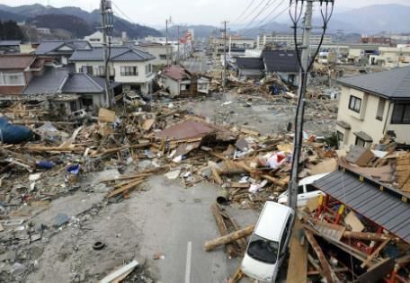 Tsunami and earthquake destruction in Japan in 2011.
Earthquake Scale and Impacts
Earthquakes vary in intensity. Some are so minor that only specialized equipment can detect them, while others are powerful enough to devastate towns and cities.
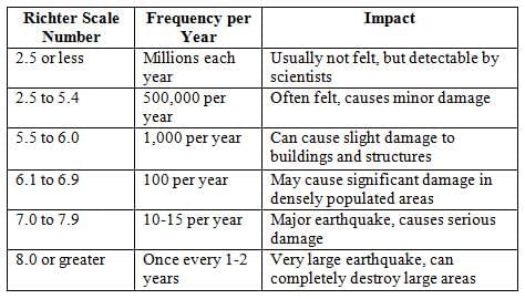
The Richter magnitude scale measures earthquake strength. Higher numbers indicate more powerful earthquakes with greater potential for damage. The largest earthquake recorded in the UK occurred in 1931 in the North Sea, registering 6.1 on the Richter scale.
Many earthquakes occur around the Pacific Ocean, where countries like Japan experience frequent seismic activity. People in these regions build earthquake-resistant structures that sway with the shock waves to avoid collapse.
In the UK, earthquakes are rare and typically so mild that most people do not notice them.
FAQs on Explore Earthquakes - Geography for Year 6
| 1. What causes an earthquake? |  |
| 2. How is the magnitude of an earthquake measured? | |
| 3. What are the primary impacts of an earthquake? | |
| 4. What safety measures can be taken during an earthquake? | |
| 5. How do scientists predict earthquakes? | |


Explore Earthquakes | Geography for Year 6
,video lectures
,ppt
,Viva Questions
,Extra Questions
,Sample Paper
,past year papers
,Summary
,Explore Earthquakes | Geography for Year 6
,Explore Earthquakes | Geography for Year 6
,Important questions
,Free
,Exam
,Previous Year Questions with Solutions
,study material
,shortcuts and tricks
,Semester Notes
,practice quizzes
,Objective type Questions
,MCQs
,mock tests for examination
;


Explore Earthquakes Free PDF Download
Importance of Explore Earthquakes
Explore Earthquakes Notes
Explore Earthquakes Year 6 Questions
Study Explore Earthquakes on the App
|
© EduRev
|
Education Revolution
|


|


