Physical Geography Chapter Notes | Social Studies for Grade 7 PDF Download
| Table of contents |
|
| Introduction |
|
| Oceans and Continents |
|
| Earth's Land Features Using Photographs |
|
| Earth's Land Features Using Satellite Images |
|

Introduction
Physical geography is the study of Earth's natural features, like land, water, and air. It helps us understand the world around us, including the oceans, continents, mountains, rivers, and other landforms. In this chapter, we will learn about the major oceans and continents, and explore different land features using photographs and satellite images. This will help us see how Earth's surface looks and how these features are connected.
Oceans and Continents
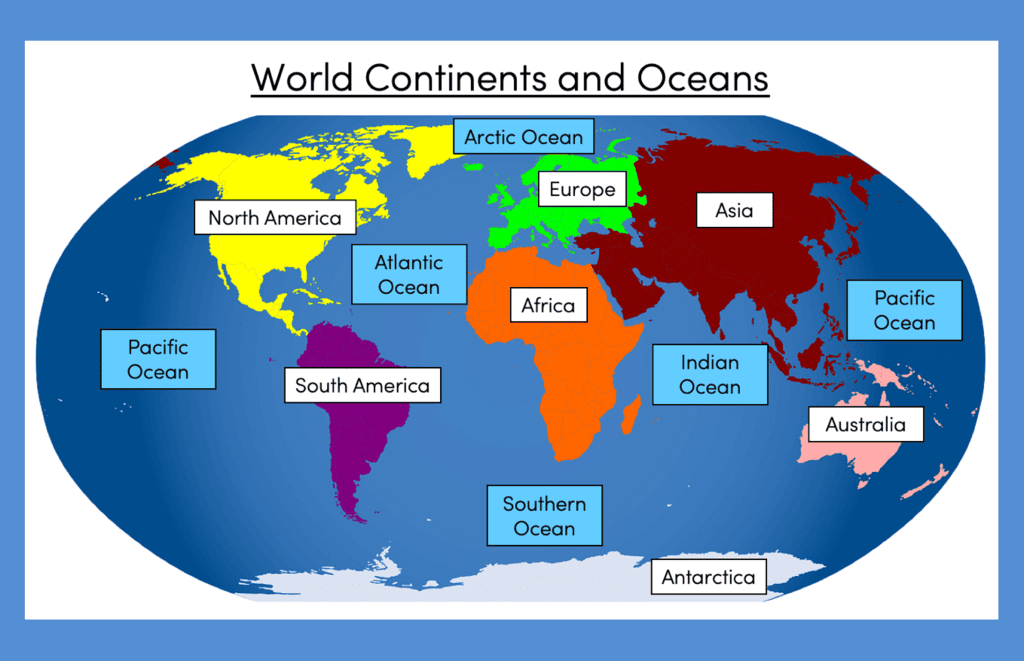 Earth has five major oceans: Pacific Ocean, Atlantic Ocean, Indian Ocean, Southern Ocean, and Arctic Ocean.
- The Pacific Ocean is the largest and deepest ocean, covering more area than all the continents combined.
- The Atlantic Ocean is the second largest and separates North and South America from Europe and Africa.
- The Indian Ocean is located south of Asia and is known for its warm waters.
- The Southern Ocean surrounds Antarctica and is very cold with strong winds.
- The Arctic Ocean is the smallest and is mostly covered with ice, located near the North Pole.
Earth has seven continents: Africa, Antarctica, Asia, Australia, Europe, North America, and South America.
- Asia is the largest continent, home to many countries and diverse landscapes like mountains and deserts.
- Africa is the second largest continent with vast deserts, rainforests, and the Nile River.
- North America includes countries like the United States, Canada, and Mexico, with features like the Rocky Mountains.
- South America has the Amazon Rainforest and the Andes Mountains.
- Europe is known for its diverse cultures and features like the Alps and many rivers.
- Australia is the smallest continent and is also considered an island, with unique animals like kangaroos.
- Antarctica is a cold, icy continent with no permanent human population, mostly used for scientific research.
Oceans and continents together make up Earth’s surface, with about 71% covered by water and 29% by land.
Earth's Land Features Using Photographs
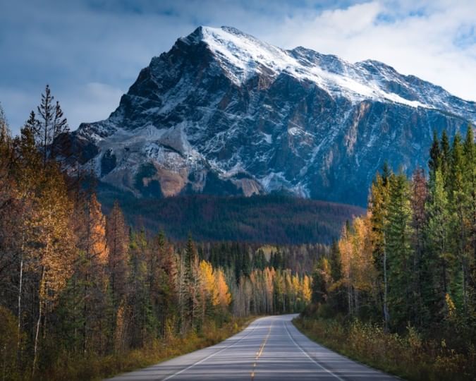
- Land features are natural shapes on Earth’s surface, like mountains, valleys, plains, and rivers.
- Mountains are high, rocky areas with steep slopes, like the Rocky Mountains in North America.
- Valleys are low areas between mountains or hills, often with rivers flowing through them, like the Grand Canyon.
- Plains are flat, wide-open areas good for farming, like the Great Plains in the United States.
- Rivers are large streams of water that flow across land, like the Mississippi River.
- Lakes are large bodies of water surrounded by land, like the Great Lakes in North America.
- Deserts are dry areas with little rain and sparse vegetation, like the Sahara Desert in Africa.
- Plateaus are flat, elevated areas higher than the surrounding land, like the Colorado Plateau.
- Hills are smaller than mountains and have gentler slopes, often covered with grass or trees.
- Canyons are deep, narrow valleys with steep sides, often carved by rivers, like the Grand Canyon.
- Coastlines are where land meets the ocean, with features like beaches and cliffs, like the California coast.
- Photographs show details like colors, textures, and shapes of these features, helping us understand how they look up close.
Earth's Land Features Using Satellite Images
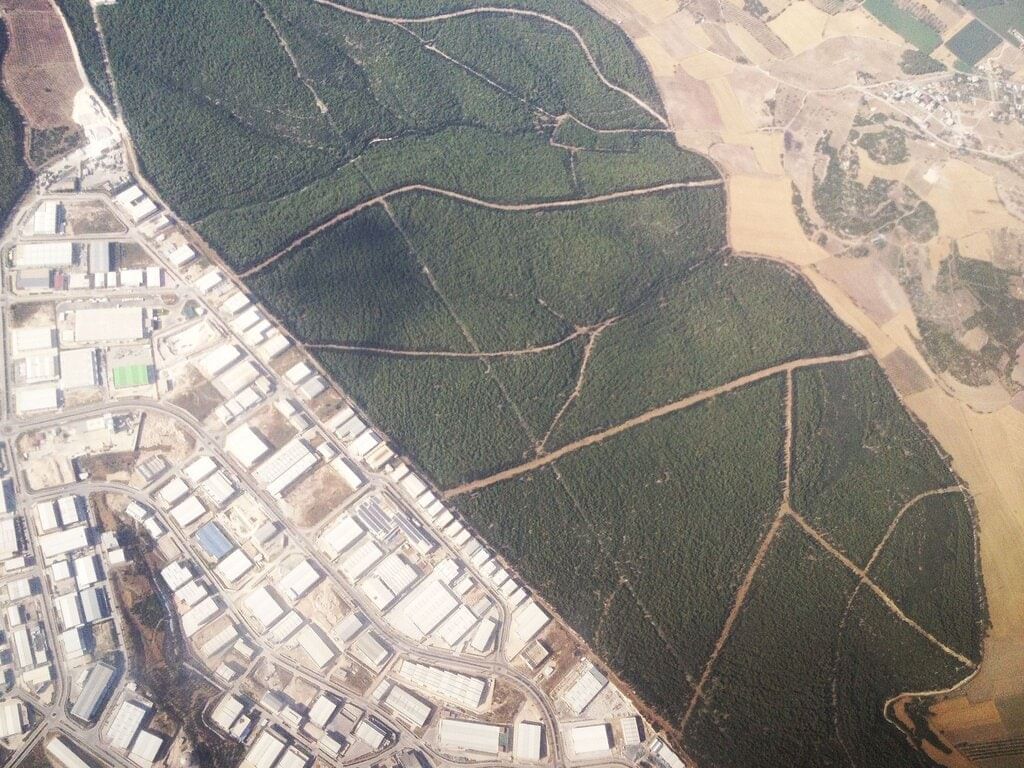 Satellite images show Earth’s land features from high above, giving a wide view of the planet’s surface.
- Mountains appear as rugged, uneven areas in satellite images, often with snowy peaks, like the Himalayas.
- Valleys look like long, narrow dips between mountains or hills in satellite images.
- Plains show up as large, flat areas with similar colors, often green or brown, indicating fields or grasslands.
- Rivers appear as winding blue or brown lines flowing across the land, like the Amazon River.
- Lakes are seen as large, still bodies of water, often with clear boundaries, like Lake Superior.
- Deserts appear as large, sandy, or rocky areas with little green, like the Mojave Desert.
- Plateaus look like flat, raised areas with sharp edges, like the Tibetan Plateau.
- Hills appear as smaller, rounded bumps compared to mountains in satellite images.
- Canyons show up as deep, narrow cuts in the land, often with a river running through, like the Grand Canyon.
- Coastlines are visible as the boundary between land and ocean, with sandy beaches or rocky cliffs.
- Satellite images help us see how land features are spread out and connected across large areas.
- These images also show patterns like river paths, forest areas, and human-made changes like cities.
FAQs on Physical Geography Chapter Notes - Social Studies for Grade 7
| 1. What are the main differences between oceans and continents? |  |
| 2. How do photographs help in understanding Earth's land features? | |
| 3. What advantages do satellite images offer in studying Earth’s land features? | |
| 4. Can you explain how Earth's land features are classified? | |
| 5. Why is it important to study physical geography? | |


Viva Questions
,Sample Paper
,Extra Questions
,ppt
,shortcuts and tricks
,past year papers
,Physical Geography Chapter Notes | Social Studies for Grade 7
,Exam
,mock tests for examination
,Free
,Objective type Questions
,video lectures
,Semester Notes
,study material
,Important questions
,practice quizzes
,Summary
,Previous Year Questions with Solutions
,Physical Geography Chapter Notes | Social Studies for Grade 7
,MCQs
,Physical Geography Chapter Notes | Social Studies for Grade 7
;


Chapter Notes: Physical Geography Free PDF Download
Importance of Chapter Notes: Physical Geography
Chapter Notes: Physical Geography
Chapter Notes: Physical Geography Grade 7 Questions
Study Chapter Notes: Physical Geography on the App
|
© EduRev
|
Education Revolution
|


|


