Grade 7 Exam > Grade 7 Notes > Social Studies for Grade 7 > Chapter Notes: Read maps
Read maps Chapter Notes | Social Studies for Grade 7 PDF Download

Introduction
Maps are like special pictures that show us places on Earth. They help us understand where things are, like cities, rivers, or mountains. By learning to read maps, we can find locations, understand directions, and explore the world. This chapter will teach you how to use lines of latitude and longitude to locate places accurately on a map. These skills are important for understanding geography and finding our way around!
Identify Lines of Latitude and Longitude
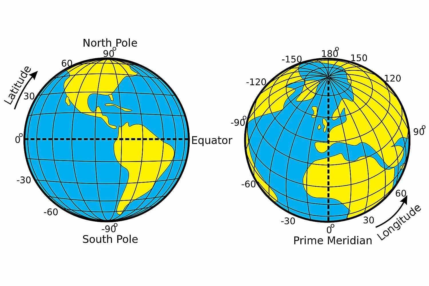
- Latitude and longitude are imaginary lines on a map that help us find exact locations.
- Lines of Latitude:
- These are horizontal lines that run east to west around the Earth.
- They are measured in degrees, from 0° to 90° north or south of the Equator.
- The Equator is the main latitude line at 0° and divides the Earth into the Northern and Southern Hemispheres.
- Other important latitude lines include the Tropic of Cancer (23.5° North), Tropic of Capricorn (23.5° South), Arctic Circle (66.5° North), and Antarctic Circle (66.5° South).
- Each degree of latitude is about 69 miles apart.
- Latitude lines never meet and are always parallel to each other.
- They help us know how far north or south a place is from the Equator.
- Lines of Longitude:
- These are vertical lines that run north to south from pole to pole.
- They are measured in degrees, from 0° to 180° east or west of the Prime Meridian.
- The Prime Meridian is the main longitude line at 0° and passes through Greenwich, England.
- Longitude lines meet at the North Pole and South Pole.
- Each degree of longitude is farther apart near the Equator and closer together near the poles.
- They help us know how far east or west a place is from the Prime Meridian.
- Latitude and longitude together form a grid system on maps to pinpoint any location on Earth.
- Coordinates are written as (latitude, longitude), like (40°N, 74°W) for New York City.
Use Lines of Latitude and Longitude
- Latitude and longitude lines help us locate places accurately on a map or globe.
- Finding a Location:
- Use coordinates to find a place, such as (latitude, longitude).
- First, find the latitude line (north or south of the Equator).
- Then, find the longitude line (east or west of the Prime Meridian).
- The point where these two lines meet is the exact location.
- For example, to find (30°N, 90°W), locate 30° North latitude and 90° West longitude; this is near New Orleans, USA.
- Understanding Directions:
- Latitude tells us if a place is in the Northern or Southern Hemisphere.
- Longitude tells us if a place is in the Eastern or Western Hemisphere.
- This helps us understand the general direction of a place from another location.
- Using Coordinates for Navigation:
- Coordinates are used in GPS systems to find exact locations.
- They help in giving directions, like traveling from one city to another.
- For example, knowing the coordinates of two places helps calculate the distance between them.
- Reading a Map Grid:
- Maps have a grid of latitude and longitude lines to make finding places easier.
- Each square on the grid has specific coordinates to help locate places within it.
- Smaller maps may show coordinates in degrees and minutes (e.g., 35°30’N) for more precision.
- Applications of Latitude and Longitude:
- They are used in geography to study climate, as latitude affects temperature.
- They help in mapping natural features like mountains, rivers, or forests.
- They are used in history to locate important events or ancient cities.
- They assist in travel, shipping, and aviation to plan routes.
The document Read maps Chapter Notes | Social Studies for Grade 7 is a part of the Grade 7 Course Social Studies for Grade 7.
All you need of Grade 7 at this link: Grade 7
FAQs on Read maps Chapter Notes - Social Studies for Grade 7
| 1. What are lines of latitude and longitude? |  |
Ans. Lines of latitude and longitude are imaginary lines that create a grid on the Earth's surface, allowing us to pinpoint specific locations. Latitude lines run horizontally and measure how far north or south a location is from the Equator, which is at 0° latitude. Longitude lines run vertically and measure how far east or west a location is from the Prime Meridian, which is at 0° longitude.
| 2. How do you read coordinates using latitude and longitude? | |
Ans. Coordinates are expressed as a pair of numbers: the first number indicates latitude, and the second indicates longitude. For example, the coordinates 40°N, 74°W refer to a location 40 degrees north of the Equator and 74 degrees west of the Prime Meridian. The direction (N, S, E, W) is crucial for accurately determining the location.
| 3. Why are lines of latitude and longitude important for navigation? | |
Ans. Lines of latitude and longitude are essential for navigation because they provide a standardized method to identify locations on Earth. They are used in mapping and navigation tools, such as GPS, allowing travelers and explorers to determine their exact position and find their way to destinations safely and efficiently.
| 4. What is the difference between the Equator and the Prime Meridian? | |
Ans. The Equator is the line of latitude at 0° that divides the Earth into the Northern and Southern Hemispheres, while the Prime Meridian is the line of longitude at 0° that divides the Earth into the Eastern and Western Hemispheres. Both serve as reference points for measuring latitude and longitude.
| 5. How can lines of latitude and longitude help in understanding climate zones? | |
Ans. Lines of latitude help in understanding climate zones because they indicate how much sunlight a region receives. Areas near the Equator (low latitudes) tend to be warmer and have tropical climates, while regions near the poles (high latitudes) are colder and often have polar climates. Longitude can also influence climate by affecting ocean currents and wind patterns.
About this Document

4.91/5
Rating

Sep 03, 2025
Last updated
Related Exams
Document Description: Chapter Notes: Read maps for Grade 7 2025 is part of Social Studies for Grade 7 preparation.
The notes and questions for Chapter Notes: Read maps have been prepared according to the Grade 7 exam syllabus. Information about Chapter Notes: Read maps covers topics
like Introduction, Identify Lines of Latitude and Longitude, Use Lines of Latitude and Longitude and Chapter Notes: Read maps Example, for Grade 7 2025 Exam. Find important definitions, questions, notes, meanings, examples, exercises and tests below for Chapter Notes: Read maps.
Introduction of Chapter Notes: Read maps in English is available as part of our Social Studies for Grade 7
for Grade 7 & Chapter Notes: Read maps in Hindi for Social Studies for Grade 7 course.
Download more important topics related with notes, lectures and mock test series for Grade 7
Exam by signing up for free. Grade 7: Read maps Chapter Notes | Social Studies for Grade 7
Description
Full syllabus notes, lecture & questions for Read maps Chapter Notes | Social Studies for Grade 7 - Grade 7 | Plus excerises question with solution to help you revise complete syllabus for Social Studies for Grade 7 | Best notes, free PDF download
Information about Chapter Notes: Read maps
In this doc you can find the meaning of Chapter Notes: Read maps defined & explained in the simplest way possible. Besides explaining types of
Chapter Notes: Read maps theory, EduRev gives you an ample number of questions to practice Chapter Notes: Read maps tests, examples and also practice Grade 7
tests

Related Searches
ppt
,Objective type Questions
,Extra Questions
,Semester Notes
,Free
,Read maps Chapter Notes | Social Studies for Grade 7
,Viva Questions
,shortcuts and tricks
,video lectures
,practice quizzes
,MCQs
,study material
,Important questions
,Summary
,Sample Paper
,Exam
,past year papers
,mock tests for examination
,Read maps Chapter Notes | Social Studies for Grade 7
,Previous Year Questions with Solutions
,Read maps Chapter Notes | Social Studies for Grade 7
;


Additional Information about Chapter Notes: Read maps for Grade 7 Preparation
Chapter Notes: Read maps Free PDF Download
The Chapter Notes: Read maps is an invaluable resource that delves deep into the core of the Grade 7 exam.
These study notes are curated by experts and cover all the essential topics and concepts, making your preparation more efficient and effective.
With the help of these notes, you can grasp complex subjects quickly, revise important points easily,
and reinforce your understanding of key concepts. The study notes are presented in a concise and easy-to-understand manner,
allowing you to optimize your learning process. Whether you're looking for best-recommended books, sample papers, study material,
or toppers' notes, this PDF has got you covered. Download the Chapter Notes: Read maps now and kickstart your journey towards success in the Grade 7 exam.
Importance of Chapter Notes: Read maps
The importance of Chapter Notes: Read maps cannot be overstated, especially for Grade 7 aspirants.
This document holds the key to success in the Grade 7 exam.
It offers a detailed understanding of the concept, providing invaluable insights into the topic.
By knowing the concepts well in advance, students can plan their preparation effectively.
Utilize this indispensable guide for a well-rounded preparation and achieve your desired results.
Chapter Notes: Read maps
Chapter Notes: Read maps Notes offer in-depth insights into the specific topic to help you master it with ease.
This comprehensive document covers all aspects related to Chapter Notes: Read maps.
It includes detailed information about the exam syllabus, recommended books, and study materials for a well-rounded preparation.
Practice papers and question papers enable you to assess your progress effectively.
Additionally, the paper analysis provides valuable tips for tackling the exam strategically.
Access to Toppers' notes gives you an edge in understanding complex concepts.
Whether you're a beginner or aiming for advanced proficiency, Chapter Notes: Read maps Notes on EduRev are your ultimate resource for success.
Chapter Notes: Read maps Grade 7 Questions
The "Chapter Notes: Read maps Grade 7 Questions" guide is a valuable resource for all aspiring students preparing for the
Grade 7 exam. It focuses on providing a wide range of practice questions to help students gauge
their understanding of the exam topics. These questions cover the entire syllabus, ensuring comprehensive preparation.
The guide includes previous years' question papers for students to familiarize themselves with the exam's format and difficulty level.
Additionally, it offers subject-specific question banks, allowing students to focus on weak areas and improve their performance.
Study Chapter Notes: Read maps on the App
Students of Grade 7 can study Chapter Notes: Read maps alongwith tests & analysis from the EduRev app,
which will help them while preparing for their exam. Apart from the Chapter Notes: Read maps,
students can also utilize the EduRev App for other study materials such as previous year question papers, syllabus, important questions, etc.
The EduRev App will make your learning easier as you can access it from anywhere you want.
The content of Chapter Notes: Read maps is prepared as per the latest Grade 7 syllabus.
|
© EduRev
|
Education Revolution
|


|


Signup to see your scores
go up
within 7 days!
within 7 days!
Takes less than 10 seconds to signup