Grade 3 Exam > Grade 3 Notes > Social Studies for Grade 3 > Chapter Notes: Physical geography
Physical geography Chapter Notes | Social Studies for Grade 3 PDF Download

Introduction
Physical geography is about exploring how the Earth looks and what makes it special. This chapter teaches us about Earth's land features, like mountains and rivers, and the big oceans and continents that cover our planet. We will learn to recognize and name these features to understand our world better!Identify Earth's Land Features Using Photographs
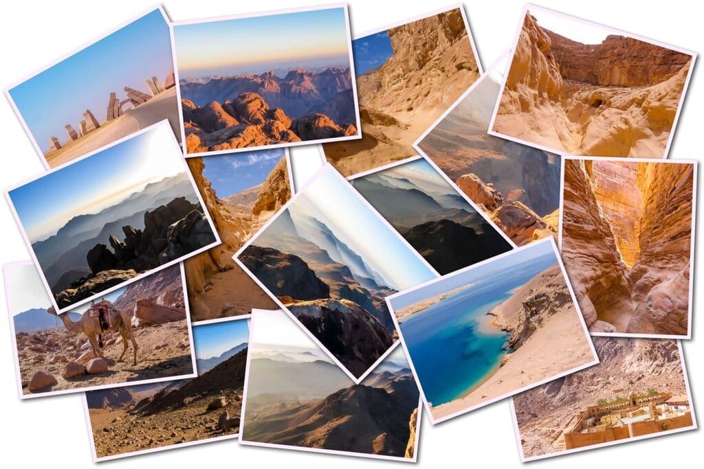 Photographs show what Earth’s land features look like in real life.
- Mountains appear as tall, rocky areas, sometimes with snow on top.
- Hills look shorter and smoother than mountains, often covered in grass.
- Plains are shown as flat, open spaces, sometimes with farms or fields.
- Valleys are low areas between hills or mountains, often with a river.
- Rivers are long, winding paths of water flowing through the land.
- Lakes are calm, large pools of water surrounded by land.
- Deserts have lots of sand or rocks with few plants or trees.
- Forests are filled with many trees and plants, often home to animals.
Photographs help us understand and recognize these land features.
Ocens and Continents
Identify Oceans and Continents
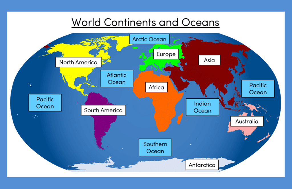 Earth is made up of large areas of water called oceans and large areas of land called continents.
- Oceans are huge bodies of salty water that cover most of the Earth’s surface.
- Continents are big pieces of land where people, animals, and plants live.
- Maps and globes show where oceans and continents are located.
- Oceans are usually colored blue on maps, while continents have different colors.
- Each ocean and continent has a unique name to tell them apart.
- Learning their names and locations helps us understand Earth’s layout.
- Some continents are close together, while others are far apart, separated by oceans.
- Maps and globes show how oceans and continents fit together like a puzzle.
Knowing oceans and continents helps us learn about the world.
Name Oceans and Continents
Earth has five oceans and seven continents, each with its own name.
- The five oceans are:
- Pacific Ocean: The largest and deepest ocean in the world.
- Atlantic Ocean: The second largest, between North America, South America, Europe, and Africa.
- Indian Ocean: A warm ocean near India and Australia.
- Southern Ocean: A cold ocean surrounding the South Pole.
- Arctic Ocean: A small, icy ocean near the North Pole.
- The seven continents are:
- North America: Includes countries like the United States and Canada.
- South America: Located below North America, with countries like Brazil.
- Africa: A large continent with deserts, jungles, and animals like elephants.
- Asia: The biggest continent, with countries like China and India.
- Australia: A continent and country with unique animals like kangaroos.
- Europe: Includes countries like France and Germany.
- Antarctica: A cold continent covered in ice, home to penguins.
The document Physical geography Chapter Notes | Social Studies for Grade 3 is a part of the Grade 3 Course Social Studies for Grade 3.
All you need of Grade 3 at this link: Grade 3
FAQs on Physical geography Chapter Notes - Social Studies for Grade 3
| 1. What are some major land features on Earth that we can identify? |  |
Ans. Some major land features on Earth include mountains, valleys, plains, plateaus, hills, deserts, and bodies of water such as rivers and lakes. These features can be identified by their distinct shapes and locations on maps and photographs.
| 2. How can I recognize different oceans and continents on a map? | |
Ans. You can recognize different oceans and continents on a map by their shapes and positions. Continents are large land masses, while oceans are vast bodies of water. Typically, oceans are labeled in blue, and continents are shown in various colors. Familiarizing yourself with the shapes of each continent can help in identifying them easily.
| 3. What are the names of the five oceans on Earth? | |
Ans. The five oceans on Earth are the Pacific Ocean, Atlantic Ocean, Indian Ocean, Southern Ocean, and Arctic Ocean. Each ocean has unique characteristics, such as size, temperature, and biodiversity.
| 4. Why is it important to learn about Earth's land features and bodies of water? | |
Ans. Learning about Earth's land features and bodies of water is important because it helps us understand our planet's geography, climate, and ecosystems. It also aids in navigation, environmental science, and understanding human impact on the Earth.
| 5. How can photographs help in identifying Earth's land features and oceans? | |
Ans. Photographs can provide visual representations of Earth's land features and oceans, making it easier to recognize and learn about them. By examining images, students can see different landscapes, such as mountains or coastlines, and compare them to maps for better understanding.
About this Document

Sep 04, 2025
Last updated
Related Exams
Document Description: Chapter Notes: Physical geography for Grade 3 2025 is part of Social Studies for Grade 3 preparation.
The notes and questions for Chapter Notes: Physical geography have been prepared according to the Grade 3 exam syllabus. Information about Chapter Notes: Physical geography covers topics
like Introduction, Identify Earth's Land Features Using Photographs, Ocens and Continents and Chapter Notes: Physical geography Example, for Grade 3 2025 Exam. Find important definitions, questions, notes, meanings, examples, exercises and tests below for Chapter Notes: Physical geography.
Introduction of Chapter Notes: Physical geography in English is available as part of our Social Studies for Grade 3
for Grade 3 & Chapter Notes: Physical geography in Hindi for Social Studies for Grade 3 course.
Download more important topics related with notes, lectures and mock test series for Grade 3
Exam by signing up for free. Grade 3: Physical geography Chapter Notes | Social Studies for Grade 3
Description
Full syllabus notes, lecture & questions for Physical geography Chapter Notes | Social Studies for Grade 3 - Grade 3 | Plus excerises question with solution to help you revise complete syllabus for Social Studies for Grade 3 | Best notes, free PDF download
Information about Chapter Notes: Physical geography
In this doc you can find the meaning of Chapter Notes: Physical geography defined & explained in the simplest way possible. Besides explaining types of
Chapter Notes: Physical geography theory, EduRev gives you an ample number of questions to practice Chapter Notes: Physical geography tests, examples and also practice Grade 3
tests

Related Searches
Physical geography Chapter Notes | Social Studies for Grade 3
,study material
,Sample Paper
,Viva Questions
,video lectures
,practice quizzes
,Semester Notes
,ppt
,Objective type Questions
,MCQs
,Important questions
,Physical geography Chapter Notes | Social Studies for Grade 3
,Free
,Extra Questions
,Exam
,Previous Year Questions with Solutions
,shortcuts and tricks
,mock tests for examination
,Summary
,past year papers
,Physical geography Chapter Notes | Social Studies for Grade 3
;


Additional Information about Chapter Notes: Physical geography for Grade 3 Preparation
Chapter Notes: Physical geography Free PDF Download
The Chapter Notes: Physical geography is an invaluable resource that delves deep into the core of the Grade 3 exam.
These study notes are curated by experts and cover all the essential topics and concepts, making your preparation more efficient and effective.
With the help of these notes, you can grasp complex subjects quickly, revise important points easily,
and reinforce your understanding of key concepts. The study notes are presented in a concise and easy-to-understand manner,
allowing you to optimize your learning process. Whether you're looking for best-recommended books, sample papers, study material,
or toppers' notes, this PDF has got you covered. Download the Chapter Notes: Physical geography now and kickstart your journey towards success in the Grade 3 exam.
Importance of Chapter Notes: Physical geography
The importance of Chapter Notes: Physical geography cannot be overstated, especially for Grade 3 aspirants.
This document holds the key to success in the Grade 3 exam.
It offers a detailed understanding of the concept, providing invaluable insights into the topic.
By knowing the concepts well in advance, students can plan their preparation effectively.
Utilize this indispensable guide for a well-rounded preparation and achieve your desired results.
Chapter Notes: Physical geography
Chapter Notes: Physical geography Notes offer in-depth insights into the specific topic to help you master it with ease.
This comprehensive document covers all aspects related to Chapter Notes: Physical geography.
It includes detailed information about the exam syllabus, recommended books, and study materials for a well-rounded preparation.
Practice papers and question papers enable you to assess your progress effectively.
Additionally, the paper analysis provides valuable tips for tackling the exam strategically.
Access to Toppers' notes gives you an edge in understanding complex concepts.
Whether you're a beginner or aiming for advanced proficiency, Chapter Notes: Physical geography Notes on EduRev are your ultimate resource for success.
Chapter Notes: Physical geography Grade 3 Questions
The "Chapter Notes: Physical geography Grade 3 Questions" guide is a valuable resource for all aspiring students preparing for the
Grade 3 exam. It focuses on providing a wide range of practice questions to help students gauge
their understanding of the exam topics. These questions cover the entire syllabus, ensuring comprehensive preparation.
The guide includes previous years' question papers for students to familiarize themselves with the exam's format and difficulty level.
Additionally, it offers subject-specific question banks, allowing students to focus on weak areas and improve their performance.
Study Chapter Notes: Physical geography on the App
Students of Grade 3 can study Chapter Notes: Physical geography alongwith tests & analysis from the EduRev app,
which will help them while preparing for their exam. Apart from the Chapter Notes: Physical geography,
students can also utilize the EduRev App for other study materials such as previous year question papers, syllabus, important questions, etc.
The EduRev App will make your learning easier as you can access it from anywhere you want.
The content of Chapter Notes: Physical geography is prepared as per the latest Grade 3 syllabus.
|
© EduRev
|
Education Revolution
|


|


Signup on EduRev and stay on top of your study goals
10M+ students crushing their study goals daily