UPSC Exam > UPSC Notes > Geography for UPSC CSE > Infographic: River Landforms
Infographic: River Landforms | Geography for UPSC CSE PDF Download

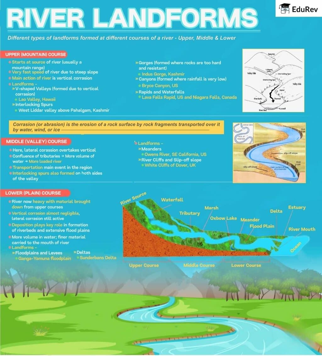
The document Infographic: River Landforms | Geography for UPSC CSE is a part of the UPSC Course Geography for UPSC CSE.
All you need of UPSC at this link: UPSC
|
264 videos|875 docs|232 tests
|
FAQs on Infographic: River Landforms - Geography for UPSC CSE
| 1. What are the primary landforms created by river erosion and deposition? |  |
Ans. The primary landforms created by river erosion include V-shaped valleys, gorges, and waterfalls, while deposition leads to the formation of features such as floodplains, deltas, and alluvial fans. Erosion occurs when the river's current wears away rock and soil, shaping the landscape, while deposition happens when sediment carried by the river settles as the water slows down or enters larger bodies of water.
| 2. How do meanders and oxbow lakes form in river systems? | |
Ans. Meanders are formed when a river flows over a gentle slope, creating curves as it erodes the outer banks and deposits sediment on the inner banks. Over time, these curves can become exaggerated. An oxbow lake forms when a meander becomes so pronounced that it creates a separate body of water, cutting off the river's original path. This process highlights the dynamic nature of river systems and their ability to reshape the landscape.
| 3. What role do tributaries play in the formation of river landforms? | |
Ans. Tributaries contribute to the overall drainage network of a river, increasing water flow and sediment load. As tributaries join the main river, they can influence erosion and deposition patterns. The interaction between tributaries and the main river can lead to the formation of various landforms, such as river valleys and deltas, by enhancing the river's ability to carve through the landscape and deposit materials in new areas.
| 4. Can you explain the concept of river terraces and how they are formed? | |
Ans. River terraces are flat areas that rise above the current level of a river, formed during periods of downcutting or when a river erodes its bed. When a river cuts into its valley floor, it can leave behind remnants of the former floodplain at higher elevations. These terraces indicate changes in the river's flow and sediment load over time, often reflecting past climatic conditions and geological activity.
| 5. What is the significance of delta formation in river systems? | |
Ans. Delta formation is significant as it represents a critical transition zone where a river meets a standing body of water, such as a lake or ocean. Deltas are characterized by rich sediment deposits that create fertile land, supporting diverse ecosystems and agriculture. They are also crucial for human settlements and economic activities, providing habitats, resources, and protection from flooding. Additionally, deltas serve as indicators of environmental changes and sediment dynamics within river systems.
About this Document

4.77/5
Rating

Sep 04, 2025
Last updated
Related Exams
Document Description: Infographic: River Landforms for UPSC 2025 is part of Geography for UPSC CSE preparation.
The notes and questions for Infographic: River Landforms have been prepared according to the UPSC exam syllabus. Information about Infographic: River Landforms covers topics
like and Infographic: River Landforms Example, for UPSC 2025 Exam. Find important definitions, questions, notes, meanings, examples, exercises and tests below for Infographic: River Landforms.
Introduction of Infographic: River Landforms in English is available as part of our Geography for UPSC CSE
for UPSC & Infographic: River Landforms in Hindi for Geography for UPSC CSE course.
Download more important topics related with notes, lectures and mock test series for UPSC
Exam by signing up for free. UPSC: Infographic: River Landforms | Geography for UPSC CSE
Description
Full syllabus notes, lecture & questions for Infographic: River Landforms | Geography for UPSC CSE - UPSC | Plus excerises question with solution to help you revise complete syllabus for Geography for UPSC CSE | Best notes, free PDF download
Information about Infographic: River Landforms
In this doc you can find the meaning of Infographic: River Landforms defined & explained in the simplest way possible. Besides explaining types of
Infographic: River Landforms theory, EduRev gives you an ample number of questions to practice Infographic: River Landforms tests, examples and also practice UPSC
tests

Related Searches
Previous Year Questions with Solutions
,video lectures
,Infographic: River Landforms | Geography for UPSC CSE
,Infographic: River Landforms | Geography for UPSC CSE
,Exam
,study material
,MCQs
,mock tests for examination
,Extra Questions
,Important questions
,Sample Paper
,past year papers
,Objective type Questions
,shortcuts and tricks
,Semester Notes
,Viva Questions
,Summary
,Free
,Infographic: River Landforms | Geography for UPSC CSE
,practice quizzes
,ppt
;


Additional Information about Infographic: River Landforms for UPSC Preparation
Infographic: River Landforms Free PDF Download
The Infographic: River Landforms is an invaluable resource that delves deep into the core of the UPSC exam.
These study notes are curated by experts and cover all the essential topics and concepts, making your preparation more efficient and effective.
With the help of these notes, you can grasp complex subjects quickly, revise important points easily,
and reinforce your understanding of key concepts. The study notes are presented in a concise and easy-to-understand manner,
allowing you to optimize your learning process. Whether you're looking for best-recommended books, sample papers, study material,
or toppers' notes, this PDF has got you covered. Download the Infographic: River Landforms now and kickstart your journey towards success in the UPSC exam.
Importance of Infographic: River Landforms
The importance of Infographic: River Landforms cannot be overstated, especially for UPSC aspirants.
This document holds the key to success in the UPSC exam.
It offers a detailed understanding of the concept, providing invaluable insights into the topic.
By knowing the concepts well in advance, students can plan their preparation effectively.
Utilize this indispensable guide for a well-rounded preparation and achieve your desired results.
Infographic: River Landforms Notes
Infographic: River Landforms Notes offer in-depth insights into the specific topic to help you master it with ease.
This comprehensive document covers all aspects related to Infographic: River Landforms.
It includes detailed information about the exam syllabus, recommended books, and study materials for a well-rounded preparation.
Practice papers and question papers enable you to assess your progress effectively.
Additionally, the paper analysis provides valuable tips for tackling the exam strategically.
Access to Toppers' notes gives you an edge in understanding complex concepts.
Whether you're a beginner or aiming for advanced proficiency, Infographic: River Landforms Notes on EduRev are your ultimate resource for success.
Infographic: River Landforms UPSC Questions
The "Infographic: River Landforms UPSC Questions" guide is a valuable resource for all aspiring students preparing for the
UPSC exam. It focuses on providing a wide range of practice questions to help students gauge
their understanding of the exam topics. These questions cover the entire syllabus, ensuring comprehensive preparation.
The guide includes previous years' question papers for students to familiarize themselves with the exam's format and difficulty level.
Additionally, it offers subject-specific question banks, allowing students to focus on weak areas and improve their performance.
Study Infographic: River Landforms on the App
Students of UPSC can study Infographic: River Landforms alongwith tests & analysis from the EduRev app,
which will help them while preparing for their exam. Apart from the Infographic: River Landforms,
students can also utilize the EduRev App for other study materials such as previous year question papers, syllabus, important questions, etc.
The EduRev App will make your learning easier as you can access it from anywhere you want.
The content of Infographic: River Landforms is prepared as per the latest UPSC syllabus.
|
© EduRev
|
Education Revolution
|


|


Signup to see your scores
go up
within 7 days!
within 7 days!
Takes less than 10 seconds to signup