The Southern Plateaus - 1 Class 4 Worksheet SST

Q1: Fill in the blanks.
(i) Hilly regions to the east and west of the Southern Plateau are called _________
Ans: The Western Ghats and the Eastern Ghats.
The Western Ghats and the Eastern Ghats are two mountain ranges that flank the Southern Plateau in India.
(ii) Chambal has a ____________flow.
Ans: Northern
The river flows north-northeast through Madhya Pradesh, running for a time through Rajasthan, then forming the boundary between Rajasthan and Madhya Pradesh.
(iii) River ______________ divides the Plateau region into two parts.
Ans: Narmada river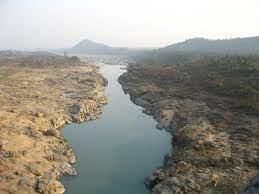 The Narmada flows westwards in the depression between the Vindhya and Satpura ranges. The plateau is watered by the east flowing Godavari and Krishna rivers.
(iv) ______________ Lands are also called Table Lands.
Ans: Plateau
A plateau is a levelled area of land, plain at the top, like a table. Therefore it is known as table land.
(v) Rivers _____________ and _____________ join the Arabian Sea.
Ans: Narmada and Tapti
The Narmada and the Tapti are the only major rivers that flow into the Arabian Sea. The total length of Narmada through the states of Madhya Pradesh, Maharashtra, and Gujarat amounts to 1312 km.
(vi) The ___________ in Karnataka is the highest waterfall in India.
Ans: Jog Falls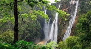 Jog Falls is located in Karnataka and is indeed the highest waterfall in India.
(vii) _______________ is the highest peak of Deccan Plateau region.
Ans: Mahabaleshwar
Mahabaleshwar is a hill station in Maharashtra and is often considered to be the highest point of the Deccan Plateau.
(viii) The annual _________________ of Puri is very famous.
Ans: Rath Yatra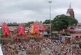 The Rath Yatra is a famous chariot festival held annually in Puri, Odisha.
(ix) Lavani is a popular dance form of __________________.
Ans: Maharashtra
Lavani is a traditional dance form that reflects the culture and heritage of Maharashtra, India.
Q2: Match the following.
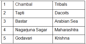
Ans: 1. Chambal - Dacoits
The exact reasons for the emergence of dacoity in the Chambal valley has been disputed. Most explanations have simply suggested feudal exploitation as the cause that provoked many people of this region to take to arms.
2. Bastar - Tribals
The major tribes of the Bastar region are the Gond, Abhuj Maria, Bhatra. Bhatra are divided into subcastes
3. Tapti - Arabian Sea
The Narmada and the Tapti are the only major rivers that flow into the Arabian Sea.
4. Nagarjuna Sagar - Krishna
Nagarjuna Sagar Dam is a masonry dam across the Krishna River at Nagarjuna Sagar which straddles the border between Nalgonda district in Telangana and Guntur district in Andhra Pradesh.
5. Godavari - Maharashtra
The Godavari is India's second longest river after the Ganga. Its source is in Trimbakeshwar, Maharashtra.
Q3: True or False.
(i) The Central Highlands include the Malwa Plateau and the Chotanagpur Plateau.
Ans: True
The Central Highlands in India are composed of three main plateaus, namely the Malwa plateau, the Deccan Plateau and Chota Nagpur Plateau.
(ii) Most of the India’s coal is mined from the Damodar valley.
Ans: True
The coalfield lies in the Damodar River valley and covers about 110 square miles (280 square km). The bituminous coal produced there is suitable for coke (most of India's coal comes from the Jharia and Raniganj fields in the valley).
(iii) Kanyakumari marks the southernmost tip of the southern plateau region.
Ans: True
It is the southern tip of Indian subcontinent. The southernmost town in mainland India, it is sometimes referred to as 'The Land's End'. The town is situated 90 km south of Trivandrum.
(iv) The Plateau is not at all important for Indian economy.
Ans: False
The plateau region plays a crucial role in India's economy, providing resources and supporting agriculture.
(v) The rivers in the Plateau region are rain fed rivers.
Ans: True
The rivers of the Southern plateau are seasonal. They are rain fed, they flow very fast and form a number of waterfalls that are not very big.
Q4: Multiple Choice Questions (MCQs).
(i) What is the shape of the southern plateaus?
(a) Triangular
(b) Round
(c) Square
(d) Rectangle
Ans: (a)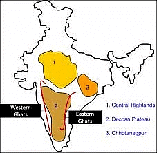 The southern plateaus of India have a triangular shape. This triangular plateau is known as the Deccan Plateau, which is bordered by the Western Ghats to the west and the Eastern Ghats to the east, forming a triangular landmass in southern India.
(ii) Which of these river do not flow through the central highlands?
(a) Son
(b) Chambal
(c) Ganga
(d) Betwa
Ans: (c)
The Ganga River does not flow through the central highlands. The central highlands of India are primarily located in the central part of the country and are characterized by elevated plateaus and hills. Rivers like the Son, Chambal, and Betwa flow through this region, but the Ganga flows to the north of this area.
(iii) _______ is cultivated in Maharashtra.
(a) Cotton
(b) Saffron
(c) Cardamom
(d) Basmati rice
Ans: (a)
Cotton is one of the major crops cultivated in the Indian state of Maharashtra. Maharashtra is known for its cotton production, particularly in regions like Vidarbha and Marathwada.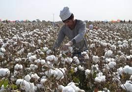
(iv) The Andaman islands are separated from the Nicobar islands by the
(a) Bay of Bengal
(b) Arabian sea
(c) Indian sea
(d) Ten degree channel
Ans: (d)
The Andaman Islands are separated from the Nicobar Islands by the Ten Degree Channel, which is a narrow channel of water in the Bay of Bengal. This channel is named because it lies approximately along the 10-degree north latitude line.
Q5: Answer the following questions.
(i) What is the most common source of irrigation in the Plateau region?
Ans: Mostly prevalent in the uneven and relatively rocky plateau of peninsular India, tanks are the most popular method of irrigation in the states of Tamil Nadu, Karnataka, Andhra Pradesh and Maharashtra.
(ii) Which rivers drops down the hills to form the famous Jog Falls?
Ans: Jog Falls is created by the Sharavati dropping 253 m (830 ft), making it the third-highest waterfall in India after the Nohkalikai Falls
(iii) Why do rivers in the Plateau region go dry in summers while the rivers in the northern plains do not?
Ans: The rivers in the Plateau region often go dry in the summer due to their seasonal nature. Unlike rivers in the northern plains, the sources of these rivers are not from melting snow. Additionally, they do not flow through high hills, resulting in a very low rate of erosion.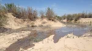
(iv) List five minerals found in the Chota Nagpur Plateau.
Ans: Here are five important minerals found in the Chota Nagpur Plateau:
- Coal
- Iron ore
- Manganese
- Bauxite
- Mica
(v) Which are the main crops grown in Maharashtra?
Ans: The main crops grown in Maharashtra include:
- Rice
- Wheat
- Jowar (sorghum)
- Bajra (pearl millet)
- Sugarcane
(vi) What do people like to eat in Tamil Nadu?
Ans: People in Tamil Nadu enjoy a variety of traditional dishes, including dosa, idli, sambhar, and rasam. They also have numerous rice-based dishes that are popular, such as:
- Curd rice
- Lemon rice
These dishes highlight the rich culinary heritage of the region.
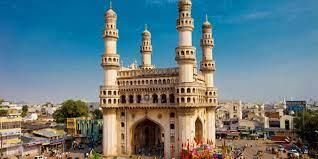
(vii) Which are the popular tourist attractions of Hyderabad?
Ans: Some popular tourist attractions in Hyderabad include:
- Charminar: An iconic symbol of the city.
- Golconda Fort: A historic fort known for its impressive architecture.
- Qutb Shahi Tombs: A collection of majestic tombs of the Qutb Shahi dynasty.
- Salar Jung Museum: One of the largest museums in India, housing a vast collection of art.
- Ramoji Film City: A popular film studio and tourist destination.
(viii) Write a short note on the state of Jharkhand.
Ans: Jharkhand is a state in eastern India, renowned for its rich mineral resources. Established in 2000 after being carved out of Bihar, Jharkhand is home to various indigenous communities and boasts a diverse cultural heritage. The economy of Jharkhand is closely linked to several key industries, including:
- Mining
- Agriculture
- Manufacturing
The capital city of Jharkhand is Ranchi.
(ix) Which hill ranges surrounded the Deccan plateau?
Ans: The Deccan Plateau is surrounded by two major hill ranges:
- Western Ghats
- Eastern Ghats
These hill ranges play a significant role in the geography and climate of the region.
(x) Where are the Andaman and Nicobar islands located?
Ans: The Andaman and Nicobar Islands are located in the Bay of Bengal, to the southeast of the Indian mainland.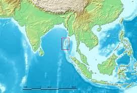
|
50 videos|246 docs|46 tests
|
FAQs on The Southern Plateaus - 1 Class 4 Worksheet SST
| 1. What are the major characteristics of the Southern Plateaus? |  |
| 2. What are some popular tourist attractions in the Southern Plateaus? | |
| 3. How were the Southern Plateaus formed? | |
| 4. What is the significance of the Southern Plateaus in terms of biodiversity? | |
| 5. How can visitors best explore the Southern Plateaus? | |


Previous Year Questions with Solutions
,The Southern Plateaus - 1 Class 4 Worksheet SST
,Objective type Questions
,Viva Questions
,practice quizzes
,The Southern Plateaus - 1 Class 4 Worksheet SST
,mock tests for examination
,Exam
,Summary
,The Southern Plateaus - 1 Class 4 Worksheet SST
,video lectures
,Sample Paper
,shortcuts and tricks
,Semester Notes
,past year papers
,Extra Questions
,Free
,MCQs
,Important questions
,ppt
,study material
;


Worksheet Solutions: The Southern Plateaus - 1 Free PDF Download
Importance of Worksheet Solutions: The Southern Plateaus - 1
Worksheet Solutions: The Southern Plateaus - 1 Notes
Worksheet Solutions: The Southern Plateaus - 1 Class 4 Questions
Study Worksheet Solutions: The Southern Plateaus - 1 on the App
|
© EduRev
|
Education Revolution
|


|


