UPSC Exam > UPSC Notes > Geography for UPSC CSE > GC Leong Summary: The Earth's Crust
GC Leong Summary: The Earth's Crust | Geography for UPSC CSE PDF Download

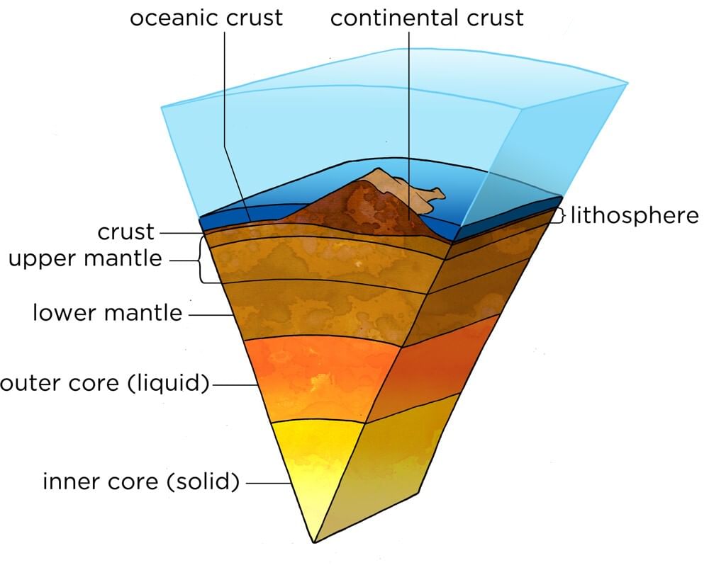
The Earth's Crust
 Granite Rocks
- Si - silica and Al- Alumina
- High density.
- Iron and calcium are also present.
- Younger part of crust - 200 million years old.
Basaltic Rocks
- Si - silica , Mg- Magnesium and Iron
- Low density.
- Aluminum, potassium, and sodium.
- Older part of the crust - 3600 million years.
Mantle forms the second layer
- Second layer of the interior of the earth.
- Two sub - layers -
- Upper mantle
- Lower mantle.
- Thickness varies between 35km - 2900 km.
- Average density is 4.5 g/cm3
- Upper portion of mantle and crust together known as Lithosphere, lower mantle - Aesthenosphere.
Core
- Third layer of the earth.
- Formed by nickel and iron.
- Also called as Nife
- Nife - Ni - nickel and Fe - ferrous or iron
- Two parts
- Outer core.
- Inner core.
- Temperature is 11000° C.
- Inner core is in solid state.
CORE - divided in two layers
1. Inner core
- Molten in stage
- Depth varies from 2900km - 5150 km.
- Density - 10.7 g/cm3.
2. Outer core
- Liquid in state
- High temperature
- High pressure
- Depth varies from - 5150 km - 6371 km
- Density - 15 g/cm3
The Classification of Rocks
Rocks are Igneous Rocks, Sedimentary Rocks, Metamorphic Rocks.
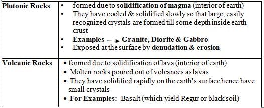
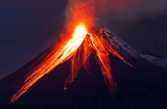
Igneous Rocks
- Formed through cooling & solidification of molten material magma (Erupted from volcanoes, molten material moves towards surface of earth through crack).
- Normally crystalline in structure, do not occur in strata & do not contains fossils.
- Can be subdivided on the basis of mineral composition.
- Basic rocks contain high proportion of basic oxides mainly of iron, aluminium & magnesium.
- When they contain high proportion of silica they are said to be Acidic, which are less dense & lighter in color than basic rocks for ex. Granite.
- Most igneous rocks are extremely hard & resistant hence are quarried for road making & polished as monuments & grave stones.
- Are parent / primary rocks as all other rocks are derived from it.
- In terms of origin they can be divided into mainly 2 classes viz.
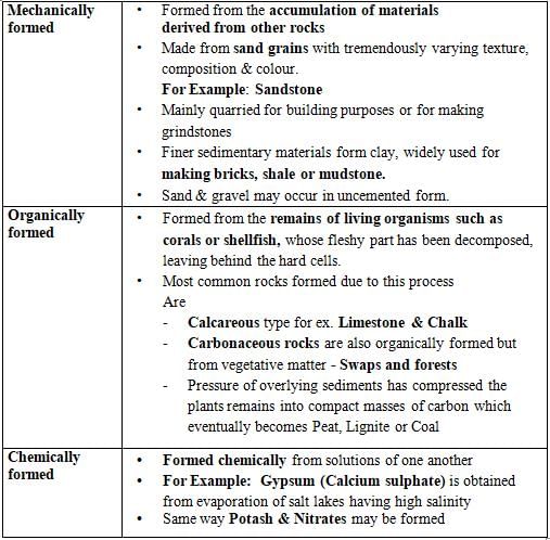
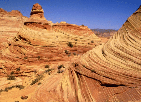
Sedimentary Rocks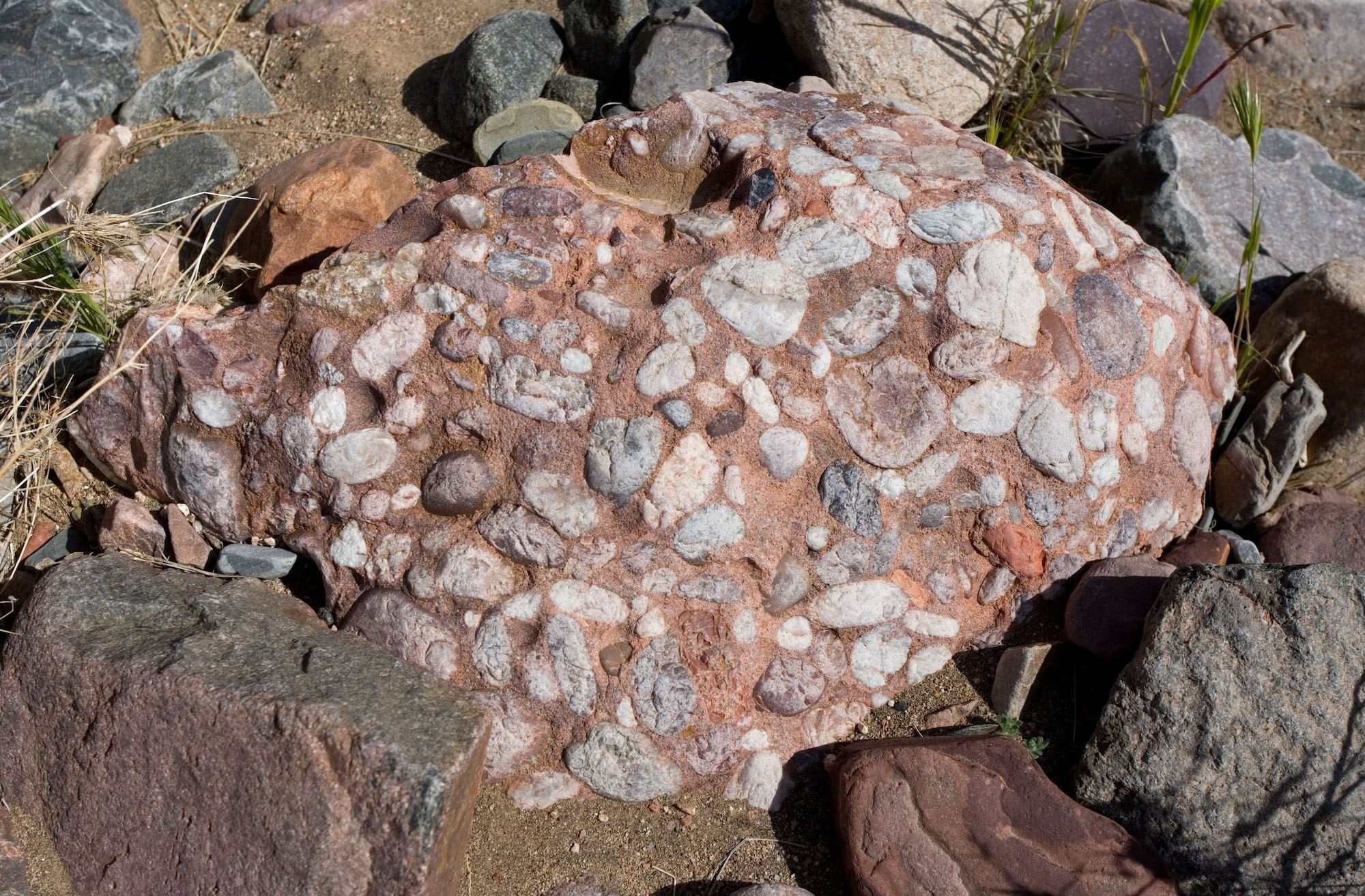
- Formed due to deposition of layers of sediment usually along the water bodies over a long period of time
- Sediment is deposited layer by layer in form of strata hence also known as stratified rocks
- Process of turning sediments into hard rock layers by pressure is known as lithification.
- Rocks may be fine grained or coarse, soft or hard & material forming them may be brought by streams, glaciers, winds or even animals.
- May be derived from Igneous, Metamorphic or Sedimentary rocks.
- Hence, Sedimentary rocks are most varied in formation of all rocks.
- They are non-crystalline & often contains fossils of animals, plants & other microorganisms.
- May be classified under 3 categories with respect to their origin & composition viz
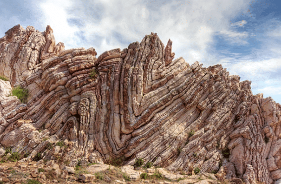
Metamorphic Rocks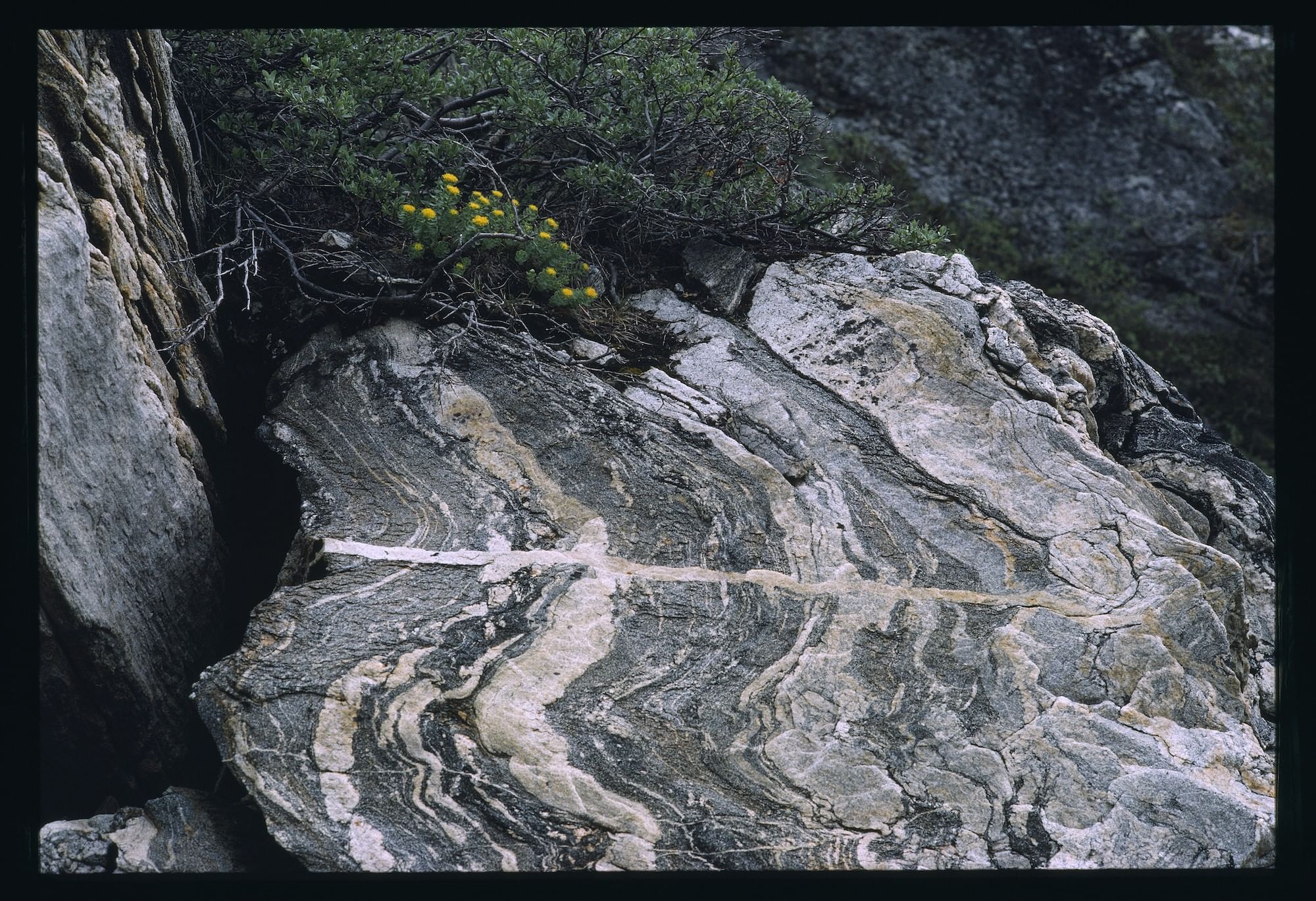 Formed when original structure of igneous & sedimentary rocks partially or wholly change under the action of heat & pressure.
- Contains no fossils
- No stratification
- For ex. Clay —> Slate Igneous to Metamorphic Granite —> Gneiss Mica —> Schist Gabro —> Serpentite Sedimentary to Metamorphic Limestone —> Marble Sandstone —> Quartzite Shale —> Schist Coal —> Graphite
Bituminous coal —> Anthracite coal
Types of Mountains
1. Fold Mountains
- Formed by folding of geosyncline sediments under compressible tectonic forces.
- For Ex. Himalaya, Alps, Rockies, Andes, Alapchhian, Ural, Aravalis
- Since the rock strata have been elevated to great heights, Fold Mountains are also called mountains of elevation.
- Are closely associated with volcanic activities.
- Contains many active volcanoes, especially in circum Pacific fold mountain system.
- Are rich in mineral resources such as Tin, Copper, Gold & Petroleum
2. Block Mountains
- Formed due to faults caused by tension or compression forces which lengthen or shorten earth’s crust.
- It causes a section of it to subside or rise above the surrounding level.
- For Ex. Vosges (France), Black Forest (Germany)
- Faulting results in formation of Block Mountains & their counterparts in rift valleys.
- In general, large scale Block Mountains & rift valleys are due to tension rather than compression.
3. Volcanic Mountains
- Also known as mountains of accumulation.
- Formed due to accumulation of thick lava as a result of volcanic eruption.
- Common in circum pacific belt.
- For Ex. Fuji Yama (Japan), Mt. Popa (Myanmar), Mt. Mauna loa (Hawai), Mt. Mayon (Phillipines), Mt. Agung (Bali), Mt. Merapi (Sumatra) & Mt. Catopaxi (Ecuador)
4. Residual / Dissected / Relict Mountains
- Formed due to waning of previously existing elevated regions by erosion.
- For Ex. Nilgiris, Parshavnath, Hills of Peninsula India, Mt. Manodnock (USA).
- Mountains evolved by denudation, where the general level of land have been lowered by agents of denudation; also known as mountains of denudation.
Types of Plateaus
- An elevated area compared to its surroundings, having a large almost flat top area (Also known as tableland).
- Like all highlands, Plateaus are also subjected to erosional processes, as a result their original characteristics are highly altered.
- According to their mode of formation & their physical appearance, plateaus may be divided into 3 types viz.
- Tectonic Plateaus
(i)Formed by earth movements which causes uplift, of a considerable size with fairly uniform altitude.
(ii)For ex. Deccan plateaus, Mesera plateau (tilted of central Iberia) & Harz plateau (Faulted of Germany).
(iii) When plateaus are surrounded by mountains they are known as intermontane plateaus for ex. Tibetian plateau, Bolivian Plateau.
(iv) When plateaus are surrounded by sea or plains they are known as Continental Plateaus For ex. Deccan plateau, Greenland plateau, South Africa plateau - Volcanic Plateau
(i) Molten lava from the volcanic eruption may solidify to form successive sheets of basalatic lava, known as Lava plateau.
(ii) For ex. Antrim Plateau of Northern island, NW part of Deccan Plateau & Columbia Snake Plateau (Biggest one). - Dissect Plateaus
(i) Formed due to continuous weathering & erosion by running water, wind & ice.
(ii) High plateaus worn down & their surface becomes irregular.
(iii) For Ex. Scottish Highland
(iv) Generally Plateaus have rich mineral resources & have been actively mined for ex.
(v) African plateau yields gold, diamonds, copper, Manganese & Chromium.
(vi) Brazilian plateau yields iron & Manganese
(vii) Deccan Plateau yields Manganese, Iron & Coal
(viii) Western Australian plateau yields Gold & Iron.
- Tectonic Plateaus
Types of Plains
Plains
- Plains usually are the best land of a country & are heavily cultivated & populated.
- Even more at places where rivers transverse the plains.
- For ex: Indo Gangetic Plains, Mississippi Plains & Yang-Tze plain .Some of the most extensive temperate plains are Grasslands like Russian Steppes, North American Prairies & Argentinian Pampas.
Plains may be grouped into 3 major types based on their mode of formation viz.
- Structural Plains
- Structurally depressed areas of the world that makes up some of the most extensive natural lowlands on the earth’s surface.
- Rock layers on the earth’s crust are aligned almost horizontally.
- They are formed by horizontally bedded rocks, relatively undisturbed by the crustal movements of the earth.
- Examples include Russian Platforms, Great plains of USA & Central lowlands of Australia.
- Depositional Plains
- Plains formed by deposition of materials brought by various agents of transportation.
- Comparatively of equal level but rise gently towards adjacent highlands.
- Depositional work by rivers form extensive alluvial plains, flood plains & deltaic plains; that form most productive agricultural plains of the world.
- For ex. Gangetic plain (for rice & jute), Nile delta of Egypt (for rice & cotton) & Hwang ho plain in China.
- Glacial Depositional plains
- Glaciers & ice sheets may deposit fluvio glacial sands & gravels in outwash plains.
- May also drop boulder clay (mixture of various sizes of boulders & clay) to form till plain or drift plain.
- Outwash plains are usually barren lands but boulder clay may be very valuable for farming.
- Aeolian Depositional plains
- Winds may blow Aeolian deposits, very fine particles known as loess, from interior deserts or barren surfaces & deposit them upon hills, valleys or plains forming a loess plateau (ex. in NW China) or a loess plain (Ex. In Pampas of Argentina)
- The loess help in leveling the undulating plain by filling up groves & depressions
- Many of the loess covered plains in the world are fertile agricultural regions.
- Erosional Plains
- These plains are carved by the agents of erosion (Rain, river, ice, and wind)
- Such plains of denudation are described as Peneplains, which means almost plains.
- In glaciated regions, glaciers & ice sheets scours & levels the land forming ice scoured plains.
- However scooped out by the ice are now filled by the lakes for ex. In Northern Europe & Northern Canada.
- Finland is estimated to have 35000 lakes occupying 10 % of total land surface of the country
- In arid & semi-arid regions, wind erosion lowers the level of the land which are called Reg in Africa.
- Mechanical weathering in arid & semi-arid areas woms mountain slopes leaving a gentle slope, known as Pediplains or Pediments; with remaining steep hills known as Inselbergs.
The document GC Leong Summary: The Earth's Crust | Geography for UPSC CSE is a part of the UPSC Course Geography for UPSC CSE.
All you need of UPSC at this link: UPSC
|
263 videos|849 docs|232 tests
|
FAQs on GC Leong Summary: The Earth's Crust - Geography for UPSC CSE
| 1. What are the main types of rocks found in the Earth's crust? |  |
Ans. The main types of rocks found in the Earth's crust are igneous, sedimentary, and metamorphic rocks. Igneous rocks form from cooled magma or lava, sedimentary rocks are created from the accumulation of mineral and organic particles, and metamorphic rocks are formed from existing rocks that have been transformed by heat and pressure.
| 2. How do tectonic plates affect the Earth's crust? | |
Ans. Tectonic plates are large sections of the Earth's crust that move and interact with one another. Their movements can lead to various geological phenomena, such as earthquakes, volcanic activity, and the formation of mountain ranges. The interactions between these plates can cause stress and deformation in the crust.
| 3. What is the significance of the Earth's crust in the rock cycle? | |
Ans. The Earth's crust plays a crucial role in the rock cycle, which is the continuous process of rock formation, breakdown, and reformation. It is the surface layer where weathering and erosion occur, leading to the formation of sedimentary rocks. Additionally, the crust contains the source materials for igneous and metamorphic rocks through processes like melting and metamorphism.
| 4. What are the characteristics of igneous rocks found in the Earth's crust? | |
Ans. Igneous rocks are characterized by their crystalline structure, which forms as magma or lava cools and solidifies. They can be classified into two main categories: intrusive (or plutonic) igneous rocks, which crystallize slowly beneath the Earth's surface, and extrusive (or volcanic) igneous rocks, which cool quickly at the surface. Common examples include granite (intrusive) and basalt (extrusive).
| 5. How do human activities impact the Earth's crust? | |
Ans. Human activities such as mining, construction, and drilling can significantly impact the Earth's crust. These activities can lead to soil erosion, habitat destruction, and the alteration of geological formations. Additionally, the extraction of resources can cause subsidence and seismic activities, affecting the stability of the crust.
About this Document

3.7K Views

4.60/5
Rating

Sep 02, 2025
Last updated
Related Exams
Document Description: GC Leong Summary: The Earth's Crust for UPSC 2025 is part of Geography for UPSC CSE preparation.
The notes and questions for GC Leong Summary: The Earth's Crust have been prepared according to the UPSC exam syllabus. Information about GC Leong Summary: The Earth's Crust covers topics
like The Earth's Crust, The Classification of Rocks and GC Leong Summary: The Earth's Crust Example, for UPSC 2025 Exam. Find important definitions, questions, notes, meanings, examples, exercises and tests below for GC Leong Summary: The Earth's Crust.
Introduction of GC Leong Summary: The Earth's Crust in English is available as part of our Geography for UPSC CSE
for UPSC & GC Leong Summary: The Earth's Crust in Hindi for Geography for UPSC CSE course.
Download more important topics related with notes, lectures and mock test series for UPSC
Exam by signing up for free. UPSC: GC Leong Summary: The Earth's Crust | Geography for UPSC CSE
Description
Full syllabus notes, lecture & questions for GC Leong Summary: The Earth's Crust | Geography for UPSC CSE - UPSC | Plus excerises question with solution to help you revise complete syllabus for Geography for UPSC CSE | Best notes, free PDF download
Information about GC Leong Summary: The Earth's Crust
In this doc you can find the meaning of GC Leong Summary: The Earth's Crust defined & explained in the simplest way possible. Besides explaining types of
GC Leong Summary: The Earth's Crust theory, EduRev gives you an ample number of questions to practice GC Leong Summary: The Earth's Crust tests, examples and also practice UPSC
tests

Related Searches
Semester Notes
,Sample Paper
,Free
,Exam
,GC Leong Summary: The Earth's Crust | Geography for UPSC CSE
,Extra Questions
,past year papers
,Viva Questions
,Important questions
,video lectures
,GC Leong Summary: The Earth's Crust | Geography for UPSC CSE
,MCQs
,study material
,practice quizzes
,Summary
,Objective type Questions
,Previous Year Questions with Solutions
,mock tests for examination
,GC Leong Summary: The Earth's Crust | Geography for UPSC CSE
,shortcuts and tricks
,ppt
;


Additional Information about GC Leong Summary: The Earth's Crust for UPSC Preparation
GC Leong Summary: The Earth's Crust Free PDF Download
The GC Leong Summary: The Earth's Crust is an invaluable resource that delves deep into the core of the UPSC exam.
These study notes are curated by experts and cover all the essential topics and concepts, making your preparation more efficient and effective.
With the help of these notes, you can grasp complex subjects quickly, revise important points easily,
and reinforce your understanding of key concepts. The study notes are presented in a concise and easy-to-understand manner,
allowing you to optimize your learning process. Whether you're looking for best-recommended books, sample papers, study material,
or toppers' notes, this PDF has got you covered. Download the GC Leong Summary: The Earth's Crust now and kickstart your journey towards success in the UPSC exam.
Importance of GC Leong Summary: The Earth's Crust
The importance of GC Leong Summary: The Earth's Crust cannot be overstated, especially for UPSC aspirants.
This document holds the key to success in the UPSC exam.
It offers a detailed understanding of the concept, providing invaluable insights into the topic.
By knowing the concepts well in advance, students can plan their preparation effectively.
Utilize this indispensable guide for a well-rounded preparation and achieve your desired results.
GC Leong Summary: The Earth's Crust Notes
GC Leong Summary: The Earth's Crust Notes offer in-depth insights into the specific topic to help you master it with ease.
This comprehensive document covers all aspects related to GC Leong Summary: The Earth's Crust.
It includes detailed information about the exam syllabus, recommended books, and study materials for a well-rounded preparation.
Practice papers and question papers enable you to assess your progress effectively.
Additionally, the paper analysis provides valuable tips for tackling the exam strategically.
Access to Toppers' notes gives you an edge in understanding complex concepts.
Whether you're a beginner or aiming for advanced proficiency, GC Leong Summary: The Earth's Crust Notes on EduRev are your ultimate resource for success.
GC Leong Summary: The Earth's Crust UPSC Questions
The "GC Leong Summary: The Earth's Crust UPSC Questions" guide is a valuable resource for all aspiring students preparing for the
UPSC exam. It focuses on providing a wide range of practice questions to help students gauge
their understanding of the exam topics. These questions cover the entire syllabus, ensuring comprehensive preparation.
The guide includes previous years' question papers for students to familiarize themselves with the exam's format and difficulty level.
Additionally, it offers subject-specific question banks, allowing students to focus on weak areas and improve their performance.
Study GC Leong Summary: The Earth's Crust on the App
Students of UPSC can study GC Leong Summary: The Earth's Crust alongwith tests & analysis from the EduRev app,
which will help them while preparing for their exam. Apart from the GC Leong Summary: The Earth's Crust,
students can also utilize the EduRev App for other study materials such as previous year question papers, syllabus, important questions, etc.
The EduRev App will make your learning easier as you can access it from anywhere you want.
The content of GC Leong Summary: The Earth's Crust is prepared as per the latest UPSC syllabus.
|
© EduRev
|
Education Revolution
|


|


Signup to see your scores
go up
within 7 days!
within 7 days!
Takes less than 10 seconds to signup