KTET Exam  >  KTET Tests  >  Kerala SET Mock Test Series 2025  >  Kerala SET Paper 2 Mock Test - 2 (Geography) - KTET MCQ

Kerala SET Paper 2 Mock Test - 2 (Geography) - KTET MCQ


Test Description

30 Questions MCQ Test Kerala SET Mock Test Series 2025 - Kerala SET Paper 2 Mock Test - 2 (Geography)

Kerala SET Paper 2 Mock Test - 2 (Geography) for KTET 2025 is part of Kerala SET Mock Test Series 2025 preparation. The Kerala SET Paper 2 Mock Test - 2 (Geography) questions and answers have been prepared according to the KTET exam syllabus.The Kerala SET Paper 2 Mock Test - 2 (Geography) MCQs are made for KTET 2025 Exam. Find important definitions, questions, notes, meanings, examples, exercises, MCQs and online tests for Kerala SET Paper 2 Mock Test - 2 (Geography) below.
Solutions of Kerala SET Paper 2 Mock Test - 2 (Geography) questions in English are available as part of our Kerala SET Mock Test Series 2025 for KTET & Kerala SET Paper 2 Mock Test - 2 (Geography) solutions in Hindi for Kerala SET Mock Test Series 2025 course. Download more important topics, notes, lectures and mock test series for KTET Exam by signing up for free. Attempt Kerala SET Paper 2 Mock Test - 2 (Geography) | 120 questions in 120 minutes | Mock test for KTET preparation | Free important questions MCQ to study Kerala SET Mock Test Series 2025 for KTET Exam | Download free PDF with solutions
Kerala SET Paper 2 Mock Test - 2 (Geography) - Question 1

Which one of the following pairs is NOT matched correctly?

Detailed Solution for Kerala SET Paper 2 Mock Test - 2 (Geography) - Question 1

David Smith : Marxist perspective is NOT matched correctly
Important Point

Kerala SET Paper 2 Mock Test - 2 (Geography) - Question 2

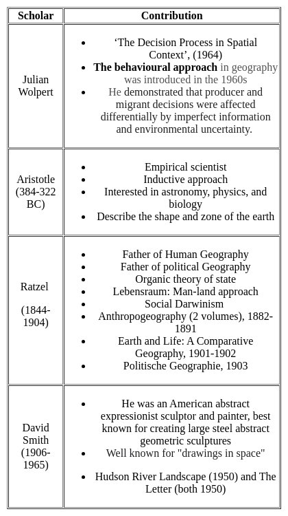
Whose work is “the study of social geography”?

Detailed Solution for Kerala SET Paper 2 Mock Test - 2 (Geography) - Question 2

George Wilson Hoke was the first person to use the term social geography. He published his paper titled “ the study of social geography”. It was published in the year 1907

Thus, the Correct answer is A.

Kerala SET Paper 2 Mock Test - 2 (Geography) - Question 3

____________ is also called ‘’stop and go determinism’’.

Detailed Solution for Kerala SET Paper 2 Mock Test - 2 (Geography) - Question 3

The correct answer is Neo-Determinism

Key PointsNeo-determinism

  • Neo-determinism reflects a middle path between two ideas of environmental determinism and possibilism.
  • It means that possibilities can be created within the limits which do not the environment.
  • Humans can control nature by obeying them. Concept: Nature of Human Geography.
  • The concept of Neo-determinism in geography is one of three major approaches in geography (the others being determinism and possibilism) that explain human and environmental relationships.
  • As, neither environmental determinism nor possibilism has been able to explain the relationship between humans and the environment correctly, hence the concept of neo-determinism emerged in geography. 
  • Neo-determinism is also called "Stop and go determinism" because it believes that if human activities (pollution) cause long-term damage to the environment then such activities should be stopped otherwise humans can do everything that the environment allows us to do.
Kerala SET Paper 2 Mock Test - 2 (Geography) - Question 4

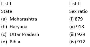
Match List I with List II :


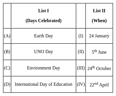
Choose the correct answer from the options given below :

Detailed Solution for Kerala SET Paper 2 Mock Test - 2 (Geography) - Question 4

International days are opportunities for educating the general public about pressing concerns.

Key Points

Therefore, (A) - (IV), (B) - (III), (C) - (II), (D) - (I) is correct options.

Additional Information

  • On November 11, India commemorates the birth anniversary of India's first Education Minister, Maulana Abul Kalam Azad, with a National Education Day.
  • Azad was a major supporter of women's education.
Kerala SET Paper 2 Mock Test - 2 (Geography) - Question 5
Which of the following coastal region in India, receives rainfall from the North-Eastern monsoon?
Detailed Solution for Kerala SET Paper 2 Mock Test - 2 (Geography) - Question 5

The correct answer is Coromandel Coast.

Key Points

  • Coromandel Coast
    • It is the coastal plain in eastern Tamil Nadu state.
    • It is bounded by the Utkal Plains to the north, the Bay of Bengal to the east, and the Kaveri delta to the south and the Eastern Ghats to the west, extending over an area of about 22,800 square kilometres.
    • The northeast monsoon winds pick up moisture from the Bay of Bengal. These winds are blocked by the mountains on the coromandel coast.
    • Because of the obstruction created by the Eastern Ghats, the Coromandel coast receives rainfall during the winter season.
    • We can also say that the Coromandel coast receives rainfall from the Retreating Monsoon during the winter season.
Kerala SET Paper 2 Mock Test - 2 (Geography) - Question 6
The famous book 'Geography of Town' was written by
Detailed Solution for Kerala SET Paper 2 Mock Test - 2 (Geography) - Question 6

The correct answer is ​A.E. Smailes.

Key Points

  • "The Geography of Towns" Edited By Arthur E. Smailes.
  • The Geography of Towns provides a concise but thorough introduction to the important subject of urban geography.
  • It traces the development of urban areas from the earliest sites of Nineveh, Aleppo, and Agade to modern megalopolises and strip cities, and deals authoritatively with problems of classification and ranking, location and type, origins, and course of development, and the relationship of the city to its region and nation.
  • All facets of urban geography are covered, including the core, integuments, population structure, land-use patterns, enclaves, and town structure.
  • Population mobility and the continual crisscross circulation of populations within and between towns and regions are seen as important forces affecting the internal geography of towns.
  • The author questions the usefulness or validity of such terms as "neighborhood" and stresses the need for more meaningful conceptualizations and vocabulary.
  • One of the fundamental problems connected with urban geography is assisting in the planning of future cities.
  • This book contributes substantially to an understanding of the interrelations of town and region and to an understanding of the components of the city itself which are essential to intelligent planning for the future.
  • Arthur E. Smailes (1911-1984) was a professor of geography, at the University of London.
  • He was a founder member of the Institute of British Geographers and also served as its secretary.
  • In his career, he was granted a chair at Queen Mary College which later became the first chair of geography, and was the recipient of the Research Medal of the Royal Scottish Geographical Society.
Kerala SET Paper 2 Mock Test - 2 (Geography) - Question 7
Consider the following statements and state which of them is true about the types of maps-

(i). Political maps show the geographical boundaries between countries, states, districts etc.

(ii). Physical maps have green to brown and grey colour scheme for showing elevation.

(iii). Shallow water body is shown with light blue colour

(iv). Cities and roads are not shown in physical map

Detailed Solution for Kerala SET Paper 2 Mock Test - 2 (Geography) - Question 7

Physical maps are used to show the natural landscape feature of the earth. They use either colours or shades to show relief. They use green, brown and grey colours to show land elevation, dark green for near sea elevation. Shades of grey is used for highest elevation. Water bodies are often shades of blue. Glaciers and ice caps shown with white.

Political maps are used to show geographical boundaries of government units like countries, states, districts, cities etc. They show roads, cities and major water features such as oceans, rivers and lakes. Political maps are also called reference maps.

Thus, the correct answer is D.

Kerala SET Paper 2 Mock Test - 2 (Geography) - Question 8
Who conceptualized electromagnetic radiation as an electromagnetic wave that travels through space at the speed of light?
Detailed Solution for Kerala SET Paper 2 Mock Test - 2 (Geography) - Question 8

James Clerk Maxwell was the one who conceptualized the wave nature of the EMR and stated that Electromagnetic energy propagates in harmonic sinusoidal wave motion, consisting of inseparable revolving electric and magnetic fields that are always perpendicular to one another and to the direction of propagation. All EM radiation travel with the same speed in a particular medium and equal to the velocity of light in a vacuum. Hence it can be stated as c=f*(lambda). Where, c= speed of light, f =frequency, lambda= wavelength.

Kerala SET Paper 2 Mock Test - 2 (Geography) - Question 9

Identify the rightly matched pairs:

1. Selvas - Amazon tropical rainforest

2. Prairies - Grasslands of Argentina and Uruguay

3. Pampas - Grasslands of North America

Select the correct answer from the options given below.
Detailed Solution for Kerala SET Paper 2 Mock Test - 2 (Geography) - Question 9
  • The hot wet equatorial climate supports a luxuriant type of vegetation – the tropical rainforest. The Amazon tropical rain forest is known as Selvas.
  • It comprises a multitude of evergreen trees that yield tropical hardwood, e.g. mahogany, ebony, greenheart, cabinet wood. Lianas, epiphytic and parasitic plants are also found. Trees of a single species are very scarce in such vegetation.
  • Bordering the deserts, away from the Mediterranean regions and in the interior continents are the temperate grasslands.
  • Though they lie in the Westerly wind belt, they are so remote from maritime influence that the grasslands are practically treeless.
  • These grasslands are so distinctive in their natural vegetation that, although those which occur in the southern hemisphere have a much more moderate climate, they are often dealt with together.
  • In the northern hemisphere, the grasslands are far more extensive and are entirely continental.
  • In Eurasia, they are called the Steppes and stretch eastwards from the shores of the Black Sea across the Great Russian plain to the foothills of the Altai Mountains, a distance of well over 2,000 miles.
  • There are isolated sections in the Pustaz of Hungary and the plains of Manchuria.
  • In North America, the grasslands are also quite extensive and are called Prairies. They lie between the foothills of the Rockies and the Great Lakes astride the American Canadian border.
  • In the case of the Pampas of Argentina and Uruguay, the grasslands extend right to the sea and enjoy much maritime influence.
  • In South Africa, the grasslands are sandwiched between the Drakensberg and the Kalahari Desert; and are further subdivided into the more tropical Bushveld in the north, and the more temperate HighVeld in the south.
Kerala SET Paper 2 Mock Test - 2 (Geography) - Question 10
Human geography is human ecology. Who gave this definition?
Detailed Solution for Kerala SET Paper 2 Mock Test - 2 (Geography) - Question 10

The correct answer is H. H. Barrows.

Key Points 

  • H. H. Barrows. was an American Geographer who believed in Social Darwinism.
  • Human Ecology studies the behavior of humans and their social, and cultural environment.

Additional Information 

Ratzel:

  • He is known as the founder of the 'New Determinism'.
  • He also added the elements from Charles Darwin's Social Darwinism.
  • According to him, similar geographical or physical locations lead to a similar type of lifestyles.

Wiedel de la Blash

  • He is also known as the 'Father of French Geography'.
  • He added to Febure's understanding in the sense that, nature sets limits and offers possibilities or options for humans to develop.
Kerala SET Paper 2 Mock Test - 2 (Geography) - Question 11

In India which age group is considered as economically productive?

Detailed Solution for Kerala SET Paper 2 Mock Test - 2 (Geography) - Question 11

The age composition of a population refers to the number of people in different age groups in a country. The number and percentage of a population found within the children, working-age and aged groups are notable determinants of the population’s social and economic structure. The population of a nation is, generally, grouped into three broad categories.
Key-Points

Children (generally below 15 years)

  • They are considered an economically unproductive group.
  • The people need to be provided with food, clothing, education, and medical care.

Working Age (15–59 years)

  • This age group is considered economically productive and biologically reproductive.
  • They comprise the working population

Aged (Above 59 years)

  • People of this age group can be economically productive though they may have retired.
  • They may be working voluntarily but they are not available for employment through recruitment.

So, it is clear that the age group of 15 - 59 years is considered as economically productive in our country.

Hence, option 2 is the correct answer.

Kerala SET Paper 2 Mock Test - 2 (Geography) - Question 12

What is remote sensing image interpretation? Choose the correct option.

Detailed Solution for Kerala SET Paper 2 Mock Test - 2 (Geography) - Question 12

Key Points

Remote sensing image interpretation

  • ​Remote sensing image interpretation is a valuable tool for a variety of applications.
  • It can be used to monitor changes in the environment, identify areas of environmental concern, and plan for future development. 
  •  The process of analyzing satellite images to identify patterns and features on the Earth's surface. This information can be used for a variety of purposes, including land use planning, environmental monitoring, and natural resource management.
  • Remote sensing images are collected by satellites that orbit the Earth. These satellites are equipped with sensors that can detect different types of electromagnetic radiation, including visible light, infrared radiation, and microwave radiation.
  • The data collected by these sensors is then processed and converted into images that can be interpreted by humans.
  • Image interpretation is a complex process that requires specialized training and knowledge. Interpreters must be able to identify the different features in an image and understand how they relate to the real world. They must also be able to use this information to draw conclusions about the landscape.

Additional Information

The process of analyzing soil samples to determine their composition: 

  • Soil sampling and analysis is a common method for assessing soil quality and fertility.
  • Soil samples are collected from different depths and locations in a field or other area of interest. The samples are then analyzed in a laboratory to determine their chemical and physical properties, such as pH, nutrient content, and texture.
  • This information can be used to make recommendations for fertilizer application, irrigation, and other management practices.

The process of analyzing water samples to determine their purity: 

  • Water quality testing is the analysis of physical, chemical, and biological characteristics of water.
  • Water samples are collected from various sources, such as rivers, lakes, streams, and groundwater wells. The samples are then analyzed in a laboratory to determine the presence of contaminants, such as bacteria, heavy metals, and pesticides.
  • This information can be used to assess the safety of drinking water and to identify sources of pollution.

The process of analyzing air samples to determine their pollution level: 

  • Air quality monitoring is the process of measuring the levels of pollutants in the air.
  • Air samples are collected from various locations, both indoors and outdoors. The samples are then analyzed in a laboratory to determine the presence of pollutants, such as particulate matter, ozone, and nitrogen dioxide.
  • This information can be used to assess the health risks associated with air pollution and to develop strategies to reduce air pollution.
Kerala SET Paper 2 Mock Test - 2 (Geography) - Question 13

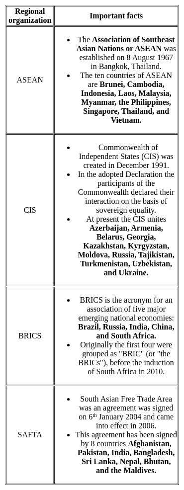
Match List-I with List-II and select the correct combination


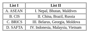
Choose the correct answer from the options given below:

Detailed Solution for Kerala SET Paper 2 Mock Test - 2 (Geography) - Question 13
Key Points 


Hence, the correct matching is A - IV, B - III, C - II, D - I

Kerala SET Paper 2 Mock Test - 2 (Geography) - Question 14
which factor has arguably diminished the strategic importance of the "Heartland" in recent times?
Detailed Solution for Kerala SET Paper 2 Mock Test - 2 (Geography) - Question 14

Answer: Option 2) Development of long-range missiles and nuclear weapons.

The Heartland Theory, once a cornerstone of geopolitical strategy, posited that control over the central Eurasian landmass could grant a nation unparalleled power and influence. However, the evolution of military technology, particularly in the post-World War II era, has challenged the theory's relevance. Among the developments that have altered the strategic landscape, the advent of long-range missiles and nuclear weapons stands out as particularly transformative.
Key Points
Development of long-range missiles and nuclear weapons:
  • The advent of long-range missiles and the proliferation of nuclear weapons have fundamentally changed the nature of military strategy and deterrence.
  • These technologies allow states to project power and exert influence far beyond their immediate geographic regions, reducing the strategic centrality of the Heartland.
  • Physical control over landmasses, while still significant, is less critical when intercontinental ballistic missiles (ICBMs) can traverse the globe.
  • Nuclear weapons, moreover, have introduced the concept of mutual assured destruction (MAD), which makes the conventional military control of vast territories less relevant to global dominance.
Additional Information
Increased global trade and economic interdependence:
  • While increased global trade and economic interdependence have indeed reshaped international relations, making economies more interconnected and reducing the likelihood of conflict among major powers, this factor has not directly diminished the Heartland's strategic importance.
  • Instead, it has contributed to a more integrated world where geopolitical strategy also considers economic leverage and trade routes.
Growing importance of access to natural resources:
  • The growing importance of access to natural resources has, in fact, potentially increased the significance of regions rich in resources, including parts of the Heartland.
  • However, resource access is a factor that enhances rather than diminishes a region's strategic value.
  • Therefore, it does not directly lead to a decrease in the Heartland's strategic importance but rather shifts the focus within geopolitical considerations.
Rise of regional powers with independent ambitions:
  • The rise of regional powers and their independent ambitions has indeed diversified the geopolitical landscape, challenging the unipolar or bipolar models that dominated Cold War-era thinking.
  • While this development has made global politics more multipolar and complex, it does not directly diminish the Heartland's strategic importance as conceptualized by Mackinder.
  • Instead, it introduces more actors with varying interests, complicating the strategic calculus.
Important Points
  • The evolution of military technology, particularly nuclear weapons and long-range missiles, exemplifies how advancements can shift the parameters of geopolitical strategy.
  • These developments have prompted strategists to reconsider traditional notions of power and control, illustrating the dynamic nature of international relations.
  • While geography remains a critical element in geopolitics, the means by which it influences global dynamics continue to evolve, reflecting broader changes in technology, politics, and society.
Kerala SET Paper 2 Mock Test - 2 (Geography) - Question 15

Given below are the two statements, one labelled as Assertion (A) and the other labelled as Reason (R). Select your answer from the code given below :

Assertion (A) : According, to Lee’s migration model, metropolitan areas are centers for immigration.

Reason (R) : The metropolitan areas have pull factors.

Code :

Detailed Solution for Kerala SET Paper 2 Mock Test - 2 (Geography) - Question 15

The metropolitan areas have forces which attract people who want to migrate. These forces include better lifestyle, employment opportunities, educational facilities, etc. These forces were termed as pull factors by Lee. Thus, metropolitan areas have pull factors and have high rates of immigration. Thus, (A) and (R) are true and (R) is the correct explanation of (A).

Kerala SET Paper 2 Mock Test - 2 (Geography) - Question 16

Census data released on july 15,2011 reflects that 13.48 percent urban population lives in

Detailed Solution for Kerala SET Paper 2 Mock Test - 2 (Geography) - Question 16

As per census 2011, Maharashtra has 13.48% of urban population. About 70% of population of India lives in rural areas. Goa & Mizoram are 1st in terms of being urban whereas Himachal Pradesh has 90% rural population, the most in India.

Kerala SET Paper 2 Mock Test - 2 (Geography) - Question 17

According to the cycle of erosion theory, what process leads to the formation of peneplains?

Detailed Solution for Kerala SET Paper 2 Mock Test - 2 (Geography) - Question 17

​​​​Answer: Option 4) Extensive erosion. 

Key Points

  •  The cycle of erosion theory, proposed by William Morris Davis, outlines the sequence of processes that shape landscapes over time.
  • Understanding the formation of specific landforms, such as peneplains, is integral to comprehending this theory.
  • Extensive erosion is characterized by the widespread removal of material over large areas, is the process that directly leads to the formation of peneplains.
  • Over time, extensive erosion gradually wears down elevated landmasses, resulting in the formation of nearly level surfaces with low relief.

Important Points

  •  Peneplains are nearly level surfaces eroded to a uniform low elevation. They typically form in regions where extensive erosion has occurred over long periods, resulting in the removal of significant amounts of material and the smoothing of once-elevated terrain.
  • Peneplains may undergo further modification through ongoing erosion processes, contributing to the dynamic nature of landscape evolution.

Additional Information

  • Tectonic uplift: Tectonic uplift contributes to changes in land elevation but does not directly lead to the formation of peneplains. Instead, it sets the stage for erosion by raising landmasses to higher elevations.
  •  Mechanical weathering: Mechanical weathering involves physical processes that break down rocks into smaller fragments but does not directly lead to the formation of peneplains. Instead, it contributes to the breakdown of rock material, making it more susceptible to erosion.
  • Glacial erosion: Glacial erosion, a process where glaciers carve and sculpt the landscape as they advance and retreat, can lead to the formation of various landforms, including U-shaped valleys. However, it does not directly lead to the formation of peneplains.
Kerala SET Paper 2 Mock Test - 2 (Geography) - Question 18
What is known as doldrums?
Detailed Solution for Kerala SET Paper 2 Mock Test - 2 (Geography) - Question 18

The correct answer is Equilateral low-pressure Belts.

Important Points

  • Doldrums, also called equatorial low-pressure belts are equatorial regions of light ocean currents and winds within the intertropical convergence zone (ITCZ), a belt of converging winds and rising air encircling Earth near the Equator. Hence, option 1 is the correct answer.
  • The northeast and southeast trade winds meet there; this meeting causes air uplift and often produces clusters of convective thunderstorms. They occur along the Equator in the Indian and western Pacific oceans and slightly north of the Equator off the African and Central American west coasts. The crews of sailing ships dreaded the doldrums because their ships were often becalmed there; the designation for the resultant state of depression was apparently thus extended to these geographic regions themselves.
Kerala SET Paper 2 Mock Test - 2 (Geography) - Question 19

Consider the following statements regarding temperature inversion:

1. Long winter nights with clear skies and still air is an ideal condition.

2. It is common throughout the year in the polar areas.

3. In hills and mountains, inversion is the result of air drainage.

Which of the above statements is/are correct?
Detailed Solution for Kerala SET Paper 2 Mock Test - 2 (Geography) - Question 19
  • Normally, temperature decreases with increase in elevation. It is called normal lapse rate.
  • At times, the situation is reversed and the normal lapse rate is inverted. It is called Inversion of temperature.
  • Inversion is usually of short duration but quite common nonetheless.
  • A long winter night with clear skies and still air is an ideal situation for inversion.
  • The heat of the day is radiated off during the night and by early morning hours, the earth is cooler than the air above.
  • Over polar areas, temperature inversion is normal throughout the year.
  • Surface inversion promotes stability in the lower layers of the atmosphere. Smoke and dust particles get collected beneath the inversion layer and spread horizontally to fill the lower strata of the atmosphere.
  • Dense fogs in the mornings are common occurrences especially during winter. This inversion commonly lasts for a few hours until the sun comes up and begins to warm the earth.
  • The inversion takes place in hills and mountains due to air drainage.
  • Cold air at the hills and mountains, produced during night, flows under the influence of gravity.
  • Being heavy and dense, the cold air acts almost like water and moves down the slope to pile up deeply in pockets and valley bottoms with warm air above. This is called air drainage.
  • It protects plants from frost damages.
Kerala SET Paper 2 Mock Test - 2 (Geography) - Question 20
Who says 'geography is the science which deals with the art of map-making'?
Detailed Solution for Kerala SET Paper 2 Mock Test - 2 (Geography) - Question 20

Key Points Contributions of Ptolemy:

  • Planetary hypothesis
  • Text on classical astronomy entitled ‘Almagest’ ( the mathematical treatise)
  • The Geography/ The Guide to Geography
  • The optics and The Tetrabiblos
  • Astrology
  • Explore the Terra-Incognita (the unknown land)
  • A detailed topographical description of places and their history called ‘chorography’
  • He said 'geography is the science which deals with the art of map-making.'

Hence, Ptolemy is the correct answer.

Additional Information

Kerala SET Paper 2 Mock Test - 2 (Geography) - Question 21

With reference to Nuclear Energy, consider the following statements:

1. It is obtained by altering the structure of atoms.

2. Uranium ore in India is found only in Rajasthan and Himachal Pradesh.

3. Nuclear energy contributes less than 1% of total power generation in India.

How many of the above statements are correct?

Detailed Solution for Kerala SET Paper 2 Mock Test - 2 (Geography) - Question 21

The correct answer is Only one​.Key PointsNuclear Energy Resources

  • It is obtained by altering the structure of atoms. Hence, Statement 1 is correct.
  • When such an alteration is made, much energy is released in the form of heat and this is used to generate electric power.
  • The Monazite sands of Kerala are also rich in Thorium.
  • Important minerals used for the generation of nuclear energy are uranium and thorium. Uranium deposits occur in the Dharwar rocks.
  • Geographically, uranium ores are known to occur in several locations along the Singhbhum Copper belt.
  • It is also found in the:
    • Udaipur, Alwar and Jhunjhunu districts of Rajasthan,
    • Durg district of Chhattisgarh,
    • Bhandara district of Maharashtra
    • Kullu district of Himachal Pradesh. Hence, Statement 2 is not correct.
  • Thorium is mainly obtained from monazite and ilmenite in the beach sands along the coast of Kerala and Tamil Nadu.
  • The world’s richest monazite deposits occur in the Palakkad and Kollam districts of Kerala.
  • The important nuclear power projects are Tarapur (Maharashtra), Rawatbhata near Kota (Rajasthan), Kalpakkam (Tamil Nadu), Narora (Uttar Pradesh), Kaiga (Karnataka) and Kakarapara (Gujarat).
  • Nuclear power is the fifth-largest source of electricity in India after coal, gas, hydroelectricity and wind power.
  • Nuclear power contributes 3.11% of total power generation in India. Hence, Statement 3 is not correct.
Kerala SET Paper 2 Mock Test - 2 (Geography) - Question 22
Which country ranks first in ICT Development Index in 2017?
Detailed Solution for Kerala SET Paper 2 Mock Test - 2 (Geography) - Question 22

The ICT Development Index (IDI) is an index published by the United Nations International Telecommunication Union based on internationally agreed information and communication technologies (ICT) indicators. Iceland ranks first in 2017 ICT Development Index.

Thus, the Correct answer is C.

Kerala SET Paper 2 Mock Test - 2 (Geography) - Question 23
Read the following statements. Which of them are true? Select your answer from the code given below:

(a) The khaddar soils are found in the low areas of valley bottom of the North Indian plains.

(b) The black regur soils are found in the Deccan plateau.

(c) The tarai region is area in the Deccan plateau.

(d) The foothills of Sahyadris have bhabar soils.

Detailed Solution for Kerala SET Paper 2 Mock Test - 2 (Geography) - Question 23

 The khaddar soils are pale brown, sandy clays and loams. They are found in the lower areas of valley bottoms of North Indian plains. Black regur soils made of the basaltic rock are found in the Deccan plateau. The tarai region is the area swampy lowland of the north Indian plain, just below the Himalayas is called tarai tract. The foothills of Shiwaliks have the bhabar soils.

Kerala SET Paper 2 Mock Test - 2 (Geography) - Question 24

Match the List-I with List-II

Choose the correct option:

Detailed Solution for Kerala SET Paper 2 Mock Test - 2 (Geography) - Question 24

The sex ratio of India, as per the census of India of 2011 is 940 females per thousand males.

  • Haryana is the state with lowest sex ratio of 879.
  • Maharashtra ranks 22nd in the whole country with sex ratio of 929
  • Bihar ranks 25th and has sex ratio of 918
  • Uttar Pradesh has sex ratio of 912 and ranks 26th in India.

Thus, the correct answer is A.

Kerala SET Paper 2 Mock Test - 2 (Geography) - Question 25
Given below are two statements. One is labelled as Assertion (A) and the other is labelled as Reason (R):

Assertion (A): Investment in SOC increases investment in Direct Productive Activities, providing cheap energy and power supply.

Reason (R) : Albert Hirschmann suggests investment in Social Overhead Capital(SOC).

Select the correct answer from options given below:

Detailed Solution for Kerala SET Paper 2 Mock Test - 2 (Geography) - Question 25

In his Theory of Unbalanced Growth Albert O. Hirschmann explains that profits and losses are symptoms of disequilibrium or imbalances in economy. He suggests that investment should be made in Social Overhead Capital (SOC) to create these imbalances. It has activities that support primary, secondary activities like education, transport and communication, drainage, etc. Investment in these leads to encouragement for investment in Direct Productive Activities (DPA). This provides cheap facilities for industries and agriculture like electricity and power supply.

Thus, the correct answer is A.

Kerala SET Paper 2 Mock Test - 2 (Geography) - Question 26
Which one of the following is the largest linguistic group of India?
Detailed Solution for Kerala SET Paper 2 Mock Test - 2 (Geography) - Question 26

The correct answer is Indo-Aryan.

Key Points

  • As per the Linguistic survey report of the 2011 census,
  • Hence. option 3 is correct.
Kerala SET Paper 2 Mock Test - 2 (Geography) - Question 27
Which of the following weathering changes the molecular structure of rocks and soil?
Detailed Solution for Kerala SET Paper 2 Mock Test - 2 (Geography) - Question 27

The correct answer is Chemical.

Key Points

  • Chemical Weathering
    • Chemical Weathering changes the molecular structure of rocks and soil. Hence, Option 2 is correct.
    • It involves multiple modes like Solution, Carbonation, Oxidation, Reduction, etc.
    • Sometimes, It dissolves large portions of limestone or other rock on the surface of the Earth to form a landscape called karst.
    • One of the world’s best examples of karst is the Stone Forest, near Kunming, China.

Additional Information

  • Mechanical Weathering
    • It is also called physical weathering. It causes rocks to crumble.
    • The change in temperature can also contribute to mechanical weathering in a process called thermal stress.
    • Change in temperature causes the rock to expand with heat and contract with cold. As this happens, again and again, the structure of the rock weakens and after some time, it breaks.
  • Biological Weathering
    • The weakening and subsequent disintegration of rock by plants, animals, and microbes are known as biological weathering.
    • Plant roots that are growing can put stress or pressure on the rock.
    • Despite the fact that the process is physical, the pressure is applied by a biological process (i.e., growing roots).
    • Chemical weathering can also be caused by biological processes, such as the production of organic acids by plant roots or microorganisms, which aid in the dissolution of minerals.
  • Leaching
    • It is the loss of water from water-soluble plant nutrients from the soil, due to rain and irrigation.
    • Water performs a number of important functions in the soil.
    • It is an effective solvent, dissolving essential soil nutrients and making them available to plant roots.
    • These dissolved nutrients are carried downward in solution, to be partly redeposited at lower levels.
    • This process, called leaching, tends to deplete the topsoil of soluble nutrients. Water is also required for many of the chemical reactions of clay and for the actions of the microorganisms that produce humus.
    • In addition, it can have considerable influence on the physical characteristics of soil by moving particles.
Kerala SET Paper 2 Mock Test - 2 (Geography) - Question 28
Who among the following has proposed model of development based on principle linear development?
Detailed Solution for Kerala SET Paper 2 Mock Test - 2 (Geography) - Question 28

Correct Answer: ​Rostow.

Key Points

  • The most popular linear stage models are Rostow’s Stages of Growth Model and the Harrod-Domar Growth Model.
  • One of the first growth theories was that proposed by American economic historian Walt Rostow in the early 1960s. Rostow’s Stages of Growth Model.
  • This approach was formulated by American Economist Walt Whitman Rostow (1916-2003). He argued in his model that the transition into development occurs in a series of stages. Each stage can only be reached through the completion of the previous stage. He asserts that all developed countries have gone through these stages and developing countries are in one of these stages. These stages are as follows:
  • Traditional society is dominated by agriculture and barter exchange, and where science and technology are not understood or exploited.
  • Pre-take-off stage, with the development of education and an understating of science, the application of science to technology and transport, and the emergence of entrepreneurs and a simple banking system, and hence rising savings.
  • Take-off, with positive growth rates in particular sectors and where organized systems of production and reward replace traditional methods and norms.
  • The drive to maturity in this stage takes place after a long period of time. The population involved in agriculture declines while industry becomes more diverse. The overall income per capita increases. The rate of savings and investments is such that it can automatically sustain economic growth.
  • Stage of Mass Consumption at this stage a country’s demand shifts from food, clothing, and other basic necessities to demand luxuries. To satisfy these needs new industries involve their selves in mass production to match consumption.
  • Rostow’s work, like many other accounts of growth, points to the significance of the accumulation of savings to achieve take-off – in this case as a necessary condition for the movement from traditional to developed societies.

Additional Information

  • Rostow's Stages of Growth model is one of the most influential development theories of the 20th century. It was, however, also grounded in the historical and political context in which he wrote. "Stages of Economic Growth" was published in 1960, at the height of the Cold War, and with the subtitle "A Non-Communist Manifesto," it was overtly political. Rostow was fiercely anti-communist and right-wing; he modeled his theory after western capitalist countries, which had industrialized and urbanized. As a staff member in President John F. Kennedy's administration, Rostow promoted his development model as part of U.S. foreign policy. Rostow's model illustrates a desire not only to assist lower-income countries in the development process but also to assert the United States' influence over that of communist Russia.
  • The theories of Rostow, Harrod Domar, and others consider savings to be a sufficient condition for growth and development. In other words, if an economy saves, it will grow, and if it grows, it must develop. Aggregate savings are largely determined by national income, so if income is low, savings will not be accumulated. According to Rostow’s theory, saving between 15% and 20% of income (a savings ratio of 0.15 – 0.2) would be enough to provide the basis for growth. If this level of saving is maintained, growth would also be sustained.

Major criticisms of this approach include:

  • Although saving is regarded as highly significant, modern growth theory takes into account a broad set of growth factors.
  • Other criticisms of the stage theory point to general weakness in terms of the unrealistic assumptions of these models, such as perfect knowledge, stable exchange rates, and constant terms of trade.
  • Most analyses were based on the reconstruction of Europe after World War II, but most developing countries do not have Europe’s institutions, attitudes, financial markets, levels of education, and desire to succeed as found in Europe.
  • Modern theory tends to see savings as a necessary but not sufficient condition for growth.
Kerala SET Paper 2 Mock Test - 2 (Geography) - Question 29

Given below are two statements. One is labelled as Assertion (A) and the other is labelled as Reason (R).

Assertion (A): Growth Centers may have a population ranging from 50000 to 500000.

Reason (R): Growth Poles would generally be the capital cities of the states.

Select the correct answer from options given below:

Detailed Solution for Kerala SET Paper 2 Mock Test - 2 (Geography) - Question 29

RP Mishra conceived in his theory of growth foci that central villages, service centers, growth point, growth centers and growth poles, ascending order in terms of their size, are all parts of the system of growth foci. According to this theory, growth poles would be the capital cities and therefore cater to the services of large number of people in the state. And next in size would be growth centers, with a population size from 50000 to 500000, which would be district headquarters.

Kerala SET Paper 2 Mock Test - 2 (Geography) - Question 30

After which one of the following tribes of India has a supercontinent of ancient geological history of the world been named?

Detailed Solution for Kerala SET Paper 2 Mock Test - 2 (Geography) - Question 30

After Gonds tribes of India has a supercontinent of ancient geological history of the world been named. The Gond people are Adivasi (indigenous people) of India that speak Dravidian languages and are listed as a Scheduled Tribe for the purpose of India's system of positive discrimination. The name "Gondwana" was proposed in 1872 by Medlicott from the ancient kingdom of the Gonds, one of the principal aboriginal tribes believed to have inhabited a large part of central India.

View more questions
30 tests
Information about Kerala SET Paper 2 Mock Test - 2 (Geography) Page
In this test you can find the Exam questions for Kerala SET Paper 2 Mock Test - 2 (Geography) solved & explained in the simplest way possible. Besides giving Questions and answers for Kerala SET Paper 2 Mock Test - 2 (Geography), EduRev gives you an ample number of Online tests for practice
Download as PDF