Geography: CUET Mock Test - 3 - CUET MCQ
30 Questions MCQ Test CUET UG Mock Test Series 2026 - Geography: CUET Mock Test - 3

Assertion (A): The rapid urbanization in India is creating a need for massive investment in urban infrastructure.
Reason (R): To accommodate the increasing urban population, which is projected to almost double in the next two decades, there is a pressing need to expand and upgrade infrastructure such as water supply, sanitation, urban transport, and urban drainage systems to ensure sustained growth and improve the quality of living
Reason (R): To accommodate the increasing urban population, which is projected to almost double in the next two decades, there is a pressing need to expand and upgrade infrastructure such as water supply, sanitation, urban transport, and urban drainage systems to ensure sustained growth and improve the quality of living
What is the estimated population increase in India's towns and cities over the next two decades?

What percentage of India's economic output is contributed by its urban areas, according to the passage?
What is the significance of the International Date Line (IDL) in the context of urbanization?
According to the passage, what is the primary challenge posed by the rapid urban transformation in India?
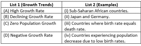
Match List-I with List-II :
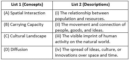
Choose the correct answer from the options given below :
Match List-I with List-II :
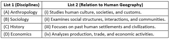
Choose the correct answer from the options given below :
Match List-I with List-II :
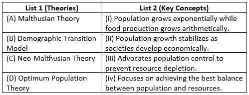
Choose the correct answer from the options given below :
Match List-I with List-II :
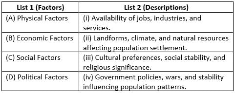
Choose the correct answer from the options given below :
Match List-I with List-II :
Choose the correct answer from the options given below :
Read the case study given below and answer the questions that follow:
“…. Buses merely skirt the periphery. Auto rickshaws cannot go there, Dharavi is part of central Mumbai where three wheelers are banned. Only one main road traverses the slum, the miscalled ‘ninety-foot road’, which has been reduced to less than half of that for most of its length. Some of the side alleys and lanes are so narrow that not even a bicycle can pass. The whole neighbourhood consists of temporary buildings, two or three storeyed high with rusty iron stairways to the upper part, where a single room is rented by a whole family, sometimes accommodating twelve or more people; it is a kind of tropical version of the industrial dwelling of Victorian London’s East End. But Dharavi is a keeper of more sombre secrets than the revulsion it inspires in the rich; a revulsion, moreover, that is, in direct proportion to the role it serves in the creation of the wealth of Bombay. In this place of shadowless, treeless sunlight, uncollected garbage, stagnant pools of foul water, where the only non- human creatures are the shining black crows and long grey rats, some of the most beautiful, valuable and useful articles in India are made. From Dharavi come delicate ceramics and pottery, exquisite embroidery and zari work, sophisticated leather goods, high-fashion garments, finely-wrought metalwork, delicate jewellery settings, wood carvings and furniture that would find its way into the richest houses, both in India and abroad. Dharavi was an arm of the sea that was filled by waste, largely produced by the people who have come to live there: Scheduled Castes and poor Muslims. It comprises rambling buildings of corrugated metal, 20 metres high in places, used for the treatment of hides and tanning. There are pleasant parts, but rotting garbage is everywhere…”
Q. Which of these are not made in Dharavi?
Read the case study given below and answer the questions that follow:
“…. Buses merely skirt the periphery. Auto rickshaws cannot go there, Dharavi is part of central Mumbai where three wheelers are banned. Only one main road traverses the slum, the miscalled ‘ninety-foot road’, which has been reduced to less than half of that for most of its length. Some of the side alleys and lanes are so narrow that not even a bicycle can pass. The whole neighbourhood consists of temporary buildings, two or three storeyed high with rusty iron stairways to the upper part, where a single room is rented by a whole family, sometimes accommodating twelve or more people; it is a kind of tropical version of the industrial dwelling of Victorian London’s East End. But Dharavi is a keeper of more sombre secrets than the revulsion it inspires in the rich; a revulsion, moreover, that is, in direct proportion to the role it serves in the creation of the wealth of Bombay. In this place of shadowless, treeless sunlight, uncollected garbage, stagnant pools of foul water, where the only non- human creatures are the shining black crows and long grey rats, some of the most beautiful, valuable and useful articles in India are made. From Dharavi come delicate ceramics and pottery, exquisite embroidery and zari work, sophisticated leather goods, high-fashion garments, finely-wrought metalwork, delicate jewellery settings, wood carvings and furniture that would find its way into the richest houses, both in India and abroad. Dharavi was an arm of the sea that was filled by waste, largely produced by the people who have come to live there: Scheduled Castes and poor Muslims. It comprises rambling buildings of corrugated metal, 20 metres high in places, used for the treatment of hides and tanning. There are pleasant parts, but rotting garbage is everywhere…”
Q. In which state is Dharavi located?
Read the case study given below and answer the questions that follow:
“…. Buses merely skirt the periphery. Auto rickshaws cannot go there, Dharavi is part of central Mumbai where three wheelers are banned. Only one main road traverses the slum, the miscalled ‘ninety-foot road’, which has been reduced to less than half of that for most of its length. Some of the side alleys and lanes are so narrow that not even a bicycle can pass. The whole neighbourhood consists of temporary buildings, two or three storeyed high with rusty iron stairways to the upper part, where a single room is rented by a whole family, sometimes accommodating twelve or more people; it is a kind of tropical version of the industrial dwelling of Victorian London’s East End. But Dharavi is a keeper of more sombre secrets than the revulsion it inspires in the rich; a revulsion, moreover, that is, in direct proportion to the role it serves in the creation of the wealth of Bombay. In this place of shadowless, treeless sunlight, uncollected garbage, stagnant pools of foul water, where the only non- human creatures are the shining black crows and long grey rats, some of the most beautiful, valuable and useful articles in India are made. From Dharavi come delicate ceramics and pottery, exquisite embroidery and zari work, sophisticated leather goods, high-fashion garments, finely-wrought metalwork, delicate jewellery settings, wood carvings and furniture that would find its way into the richest houses, both in India and abroad. Dharavi was an arm of the sea that was filled by waste, largely produced by the people who have come to live there: Scheduled Castes and poor Muslims. It comprises rambling buildings of corrugated metal, 20 metres high in places, used for the treatment of hides and tanning. There are pleasant parts, but rotting garbage is everywhere…”
Q. According to the passage, earlier Dharavi was a/an _________ of the sea?
Read the case study given below and answer the questions that follow:
“…. Buses merely skirt the periphery. Auto rickshaws cannot go there, Dharavi is part of central Mumbai where three wheelers are banned. Only one main road traverses the slum, the miscalled ‘ninety-foot road’, which has been reduced to less than half of that for most of its length. Some of the side alleys and lanes are so narrow that not even a bicycle can pass. The whole neighbourhood consists of temporary buildings, two or three storeyed high with rusty iron stairways to the upper part, where a single room is rented by a whole family, sometimes accommodating twelve or more people; it is a kind of tropical version of the industrial dwelling of Victorian London’s East End. But Dharavi is a keeper of more sombre secrets than the revulsion it inspires in the rich; a revulsion, moreover, that is, in direct proportion to the role it serves in the creation of the wealth of Bombay. In this place of shadowless, treeless sunlight, uncollected garbage, stagnant pools of foul water, where the only non- human creatures are the shining black crows and long grey rats, some of the most beautiful, valuable and useful articles in India are made. From Dharavi come delicate ceramics and pottery, exquisite embroidery and zari work, sophisticated leather goods, high-fashion garments, finely-wrought metalwork, delicate jewellery settings, wood carvings and furniture that would find its way into the richest houses, both in India and abroad. Dharavi was an arm of the sea that was filled by waste, largely produced by the people who have come to live there: Scheduled Castes and poor Muslims. It comprises rambling buildings of corrugated metal, 20 metres high in places, used for the treatment of hides and tanning. There are pleasant parts, but rotting garbage is everywhere…”
Q. To which place has Dharavi been compared to?
Read the case study given below and answer the questions that follow:
“…. Buses merely skirt the periphery. Auto rickshaws cannot go there, Dharavi is part of central Mumbai where three wheelers are banned. Only one main road traverses the slum, the miscalled ‘ninety-foot road’, which has been reduced to less than half of that for most of its length. Some of the side alleys and lanes are so narrow that not even a bicycle can pass. The whole neighbourhood consists of temporary buildings, two or three storeyed high with rusty iron stairways to the upper part, where a single room is rented by a whole family, sometimes accommodating twelve or more people; it is a kind of tropical version of the industrial dwelling of Victorian London’s East End. But Dharavi is a keeper of more sombre secrets than the revulsion it inspires in the rich; a revulsion, moreover, that is, in direct proportion to the role it serves in the creation of the wealth of Bombay. In this place of shadowless, treeless sunlight, uncollected garbage, stagnant pools of foul water, where the only non- human creatures are the shining black crows and long grey rats, some of the most beautiful, valuable and useful articles in India are made. From Dharavi come delicate ceramics and pottery, exquisite embroidery and zari work, sophisticated leather goods, high-fashion garments, finely-wrought metalwork, delicate jewellery settings, wood carvings and furniture that would find its way into the richest houses, both in India and abroad. Dharavi was an arm of the sea that was filled by waste, largely produced by the people who have come to live there: Scheduled Castes and poor Muslims. It comprises rambling buildings of corrugated metal, 20 metres high in places, used for the treatment of hides and tanning. There are pleasant parts, but rotting garbage is everywhere…”
Q. Why auto rickshaws cannot go in Dharavi?
The major factor responsible for water pollution is
'Railways' Integral Coach Factory (ICF) is located at which of the following places?
Which of the following ‘passes’ is located in Sikkim?
Indian Railways earn the maximum revenue from _________.
Given below are two statements:
Statement I: Railways are more economical for transporting large volumes over long distances.
Statement II: Air transport is generally preferred for moving heavy cargo due to cost efficiency.
Given below are two statements:
Statement I: The Trans-Siberian Railway is the longest transcontinental railway in the world.
Statement II: The Trans-Siberian Railway connects Vancouver with St. John’s City in Canada.
____ has officially proclaimed the Gross National Happiness Index as the measure of the country's progress.
Jobs that involve high degrees and level of innovations are known as:
Which of the following is correct about the economic activities?
Consider the following statements regarding the tertiary sector:
1. Trade, transport and communication facilities are grouped under the “exchange” part of the tertiary sector.
2. Tertiary activities are directly involved in the processing of physical raw materials.
3. Tertiary activities rely more on the production techniques, machinery and factory processes.
Which of the above statements is/are incorrect?In which sector is India's maximum population employed, according to the Census of 2011?
|
39 docs|145 tests
|
Important Questions for Geography: CUET Mock Test - 3
Geography: CUET Mock Test - 3 MCQs with Answers
Online Tests for Geography: CUET Mock Test - 3 CUET UG Mock Test Series 2026
|
© EduRev
|
Education Revolution
|


|


