Air Force Group Y Mock Test - 8 - Airforce X Y / Indian Navy SSR MCQ
30 Questions MCQ Test - Air Force Group Y Mock Test - 8

Find out the Synonym of the following word:
RECKLESS

The stuents were / awating for / the arrival of the chief guest / No error.
Find the word most appropriate for Blank no. 20
The (11)____ citizen who has to get everyday jobs done by various municipal and government departments is (12)____ driven up a tree, first (13)____ them, second explaining to them what is (14)____ and lastly, getting the job done.
If this week I (15)____ some personal experience in this column, it is because I can document them. It is not to ask for any special (16)____ or voice personal (17)____ but to bring into public view the experience of hundreds, if not thousands of citizens everyday of the year and express the collective (18)____ of all of them. Because one’s usual experience is that when such complaints are (19)____ in such columns, the departments rush to (20)____
Find the word most appropriate for Blank no. 29
Our study about women’s place in Indian society is mainly based on urban, professional and educated Indian women. Deep in the rural heartland of the country, the rapidly changing world has not even touched the (29)____ of the life of a women. Most men of orthodox families take (30)____ in revealing that their (31)____ folk stay in ‘purdah’, a shield that (32)____ a woman of the joys of free nature. Still more alarming are the (33)____ of atrocities of women (34)____ incidents at Bantala, Singur and Birati are (35)____
DIRECTIONS: The following question contains an idiom and its usage in a sentence, followed by four possible meanings labelled A, B, C, and D. Pick out the right meaning of the idiom in question and mark your answer accordingly.
Q.
Elbow grease.
He has reached this high stature through "elbow grease".
Although the initial setup of generators and a power grid by Edison and JP Morganwas rather costly, the electrification of lighting in lower Manhattan doubled work efficiency when the energy costs were cut in half.
Because the economic cycle in the United States changes little during its 20-yearinterval between recessing, it is fairly easy for analysts to predict analogous trendsin the stock market.
Directions: In the given statements, a blank has been given. This needs to be filled up using the correct combination of words from the three options mentioned, so that the resulting statement is grammatically and contextually correct.
In the ancient times, remaining alone was dangerous as _______________ animals could easily attack its solitary prey.
I. domesticated
II. wild
III. herbivorous
Which one best expresses the given sentence in Passive/Active Voice?
Has someone made all the necessary arrangements?
Direction: The sentences given in the question, when properly sequenced, form a coherent paragraph. Each sentence is labeled with a letter. Choose the most logical order of sentences from the given choices to construct a coherent paragraph.
A. As people turned to farming, they began to live in fixed settlements, which became small towns.
B. Their labors bore fruit; surplus food freed some of the population from farming.
C. In about 5000 BC, farmers moved down into the fertile river valleys of Mesopotamia, and built dykes and ditches to irrigate the arid land.
D. The cultivation of plants, such as wheat and barley, and the domestication of animals, such as sheep, goats and cattle, began in the Near East in about 8500 BC.
Direction: The sentences given in the question, when properly sequenced, form a coherent paragraph. Each sentence is labeled with a letter. Choose the most logical order of sentences from the given choices to construct a coherent paragraph.
A. Not long after their victory, the Greeks began to think that they would never stack up to the glories of the past.
B. Throughout antiquity, those warriors, especially the Marathonomachai, who fought and defeated the Persian troops in the 490 BCE Battle of Marathon, would be revered as Athens’ Greatest Generation.
C. Even in the mid-fifth century BCE, Athenians were already looking back with longing.
D. A few decades earlier, Athenian citizen-soldiers had helped to rout the Persian invaders of Greece.
Directions: Read the following passage carefully and answer the questions given beside.
Remote sensing and GIS are promising tools for handling spatial and temporal data and help in integrating them for successful planning of natural resources. It is the science of measuring the earth using sensors mounted on high-flying aircrafts or satellites. These sensors collect data in the form of images and provide insights for manipulating, analysing and visualising those images. Since natural resources are not uniformly distributed and are spatially varied, it is challenging to capture the correct picture. Management of natural resources calls for scientific tools for timely and accurate dissemination of information. In natural resource management, remote sensing and GIS are mainly used in the mapping process. These techniques are useful in management of land, soil, coastal, watershed, urban and many more.
In India, the agriculture sector alone sustains the livelihood of around 50 percent of the population. Therefore, an increase in crop productivity has been a major concern. Since, the scope for increasing area under agriculture is limited, advanced crop production forecasting is required for better policymaking. Indian Space Research Agency (ISRO) and Indian Council of Agricultural Research (ICAR) successful experiment-Agricultural Resource Inventory and Survey Experiment (ARISE) used aerial colour photographs to estimate crop acreage in many states of India. Other Important uses of remote sensing include crop identification, stress detection, and crop yield modelling, drought monitoring, land degradation mapping and more. Urbanisation is important and inevitable for development, but its proper planning and management is crucial for sustenance. One of the important features of GIS is multilayered mapping. This kind of mapping helps municipal corporations, town planning boards to build cities that are better organised. The information systems with socio-economic data overlaid upon satellite data makes urban planning cost-effective and accurate.
Coastal ecosystems have high ecological significance. GIS and remote sensing data are used to study coastal ecosystems and marine living resources which include habitats like mangroves, coral reefs and more. Apart from this, suspended shoreline dynamics can be studied and climatic changes leading to cyclones and sea level rise may be of special interest too. Geospatial data is effective in the analysis and determination of factors that affect the utilisation of these resources. The technologies provide a platform through which we can generate information that can be used to make sound decisions for sustainable development of the natural resources of India.
Q. How effective are remote sensing and GIS in managing urban growth?
I. GIS and remote sensing are helpful in building cities that are better organized.
II. The system makes urban planning cost-effective and accurate.
III. They help the government disseminate people living in extremely densed areas to less populated ones.
Directions: Read the following passage carefully and answer the questions given beside.
Remote sensing and GIS are promising tools for handling spatial and temporal data and help in integrating them for successful planning of natural resources. It is the science of measuring the earth using sensors mounted on high-flying aircrafts or satellites. These sensors collect data in the form of images and provide insights for manipulating, analysing and visualising those images. Since natural resources are not uniformly distributed and are spatially varied, it is challenging to capture the correct picture. Management of natural resources calls for scientific tools for timely and accurate dissemination of information. In natural resource management, remote sensing and GIS are mainly used in the mapping process. These techniques are useful in management of land, soil, coastal, watershed, urban and many more.
In India, the agriculture sector alone sustains the livelihood of around 50 percent of the population. Therefore, an increase in crop productivity has been a major concern. Since, the scope for increasing area under agriculture is limited, advanced crop production forecasting is required for better policymaking. Indian Space Research Agency (ISRO) and Indian Council of Agricultural Research (ICAR) successful experiment-Agricultural Resource Inventory and Survey Experiment (ARISE) used aerial colour photographs to estimate crop acreage in many states of India. Other Important uses of remote sensing include crop identification, stress detection, and crop yield modelling, drought monitoring, land degradation mapping and more. Urbanisation is important and inevitable for development, but its proper planning and management is crucial for sustenance. One of the important features of GIS is multilayered mapping. This kind of mapping helps municipal corporations, town planning boards to build cities that are better organised. The information systems with socio-economic data overlaid upon satellite data makes urban planning cost-effective and accurate.
Coastal ecosystems have high ecological significance. GIS and remote sensing data are used to study coastal ecosystems and marine living resources which include habitats like mangroves, coral reefs and more. Apart from this, suspended shoreline dynamics can be studied and climatic changes leading to cyclones and sea level rise may be of special interest too. Geospatial data is effective in the analysis and determination of factors that affect the utilisation of these resources. The technologies provide a platform through which we can generate information that can be used to make sound decisions for sustainable development of the natural resources of India.
Q. Why, according to the passage, are GIS and remote sensing considered as promising tools?
I. They collect data in the form of graphs.
II. They provide scope for manipulating, analyzing and visualizing the images.
III. They disseminate data’s more accurately.
Directions: Read the following passage carefully and answer the questions given beside.
Remote sensing and GIS are promising tools for handling spatial and temporal data and help in integrating them for successful planning of natural resources. It is the science of measuring the earth using sensors mounted on high-flying aircrafts or satellites. These sensors collect data in the form of images and provide insights for manipulating, analysing and visualising those images. Since natural resources are not uniformly distributed and are spatially varied, it is challenging to capture the correct picture. Management of natural resources calls for scientific tools for timely and accurate dissemination of information. In natural resource management, remote sensing and GIS are mainly used in the mapping process. These techniques are useful in management of land, soil, coastal, watershed, urban and many more.
In India, the agriculture sector alone sustains the livelihood of around 50 percent of the population. Therefore, an increase in crop productivity has been a major concern. Since, the scope for increasing area under agriculture is limited, advanced crop production forecasting is required for better policymaking. Indian Space Research Agency (ISRO) and Indian Council of Agricultural Research (ICAR) successful experiment-Agricultural Resource Inventory and Survey Experiment (ARISE) used aerial colour photographs to estimate crop acreage in many states of India. Other Important uses of remote sensing include crop identification, stress detection, and crop yield modelling, drought monitoring, land degradation mapping and more. Urbanisation is important and inevitable for development, but its proper planning and management is crucial for sustenance. One of the important features of GIS is multilayered mapping. This kind of mapping helps municipal corporations, town planning boards to build cities that are better organised. The information systems with socio-economic data overlaid upon satellite data makes urban planning cost-effective and accurate.
Coastal ecosystems have high ecological significance. GIS and remote sensing data are used to study coastal ecosystems and marine living resources which include habitats like mangroves, coral reefs and more. Apart from this, suspended shoreline dynamics can be studied and climatic changes leading to cyclones and sea level rise may be of special interest too. Geospatial data is effective in the analysis and determination of factors that affect the utilisation of these resources. The technologies provide a platform through which we can generate information that can be used to make sound decisions for sustainable development of the natural resources of India.
Q. What is the tone of the author?
Directions: Out of the given alternatives, choose the one which can be substituted for the given words/sentence.
A person learning a trade under someone
What name is the elected representative who are not the members of the ruling party
In the context of the Indian freedom struggle, 16th October 1905 is well known for which one of the following reasons?
What is the rate of simple interest for the first 4 years if the sum of Rs. 360 becomes Rs. 540 in 9 years and the rate of interest for the last 5 years is 6%?
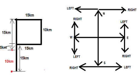
Nishu starting from a fixed point goes 15 km towards North and then after turning to his right he goes 15 km. Then he goes 10, 15 and 15 Km after turning to his left each time. How far is he from his starting point?
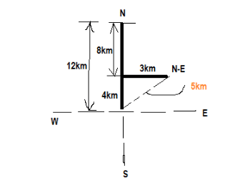
Anjali goes 12 km towards North from a fixed point and then she goes 8 km towards South from there. In the end she goes 3 km towards east. How far and in what direction is she from her starting point?
Find the last number which when divided by 6, 8, 15 and 30 leaves remainder 2, 4, 11 and 26 respectively?
Directions to Solve
In each of the following questions find out the alternative which will replace the question mark.
Question -
PASS : QBTT :: FAIL : ?

Directions to Solve
In each of the following questions two statements are given and these statements are followed by two conclusions numbered (1) and (2). You have to take the given two statements to be true even if they seem to be at variance from commonly known facts. Read the conclusions and then decide which of the given conclusions logically follows from the two given statements, disregarding commonly known facts.
Question -
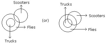
Statements: All the trucks are flies. Some scooters are flies.
Conclusions:
- All the trucks are scooters.
- Some scooters are trucks.
Sensation of sound persists in our brain for about -
What was the purpose of the Maritime Partnership Exercise (MPX) conducted by India and France in the Bay of Bengal?
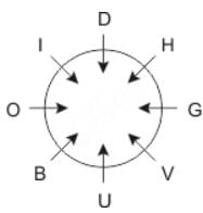
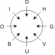
Directions: Study the following information carefully and answer the question given below.
Eight people O, H, U, V, I, D, B and G are sitting around a circular table facing the centre.
O is sitting second to the left of U and third to right of H. D and I are immediate neighbors of each other and one of them is an immediate neighbor of O. V is sitting second to the right of B. G is sitting second to the left of D.
Q. Which of the following persons sitting between H and V?
Important Questions for Air Force Group Y Mock Test - 8
Air Force Group Y Mock Test - 8 MCQs with Answers
Online Tests for Air Force Group Y Mock Test - 8
|
© EduRev
|
Education Revolution
|


|


