UGC NET Exam  >  UGC NET Tests  >  UGC NET Mock Test Series 2025  >  UGC NET Paper 2 Geography Mock Test - 3 - UGC NET MCQ

UGC NET Paper 2 Geography Mock Test - 3 - UGC NET MCQ


Test Description

30 Questions MCQ Test UGC NET Mock Test Series 2025 - UGC NET Paper 2 Geography Mock Test - 3

UGC NET Paper 2 Geography Mock Test - 3 for UGC NET 2025 is part of UGC NET Mock Test Series 2025 preparation. The UGC NET Paper 2 Geography Mock Test - 3 questions and answers have been prepared according to the UGC NET exam syllabus.The UGC NET Paper 2 Geography Mock Test - 3 MCQs are made for UGC NET 2025 Exam. Find important definitions, questions, notes, meanings, examples, exercises, MCQs and online tests for UGC NET Paper 2 Geography Mock Test - 3 below.
Solutions of UGC NET Paper 2 Geography Mock Test - 3 questions in English are available as part of our UGC NET Mock Test Series 2025 for UGC NET & UGC NET Paper 2 Geography Mock Test - 3 solutions in Hindi for UGC NET Mock Test Series 2025 course. Download more important topics, notes, lectures and mock test series for UGC NET Exam by signing up for free. Attempt UGC NET Paper 2 Geography Mock Test - 3 | 100 questions in 120 minutes | Mock test for UGC NET preparation | Free important questions MCQ to study UGC NET Mock Test Series 2025 for UGC NET Exam | Download free PDF with solutions
UGC NET Paper 2 Geography Mock Test - 3 - Question 1

Western disturbances are extratropical storms that bring sudden winter rain to the northern parts of India. They originate in ______.

Detailed Solution for UGC NET Paper 2 Geography Mock Test - 3 - Question 1

The correct answer is the Mediterranean Sea.

Key PointsWestern disturbances are extratropical storms that bring sudden winter rain to the northern parts of India. They originate in the Mediterranean Sea

Western Disturbances

  • Western Disturbances form in the mid-latitude area, situated north of the Tropic of Cancer. This is why they are referred to as mid-latitude storms or extra-tropical storms
  • Western Disturbances are low-pressure systems, embedded in western winds (westerlies)  that flow from west to east.

Arrival in India

  • Western Disturbances begin is a low-pressure system that originates in the Mid-latitude region near the Atlantic Ocean and Europe.
  • The low pressure typically forms over the Mediterranean Sea and travels over Iran, Iraq,  Afghanistan, and Pakistan before entering India loaded with moisture.
  • These moisture-laden western disturbances eventually come up against the Himalayas and get blocked, as a consequence, the moisture gets trapped and precipitation is shared in the form of snow and rain over Northwest India and other parts of North India. 
  • An average of 4-5 western disturbances form during the winter season and the rainfall distribution and amount varies with every western disturbance.
  • The word 'Western' refers to the direction from which they originate in India.
  • The word 'disturbance' is used because the air within the low-pressure systems tends to be unstable or disturbed.
  • When western disturbances become more intense in the Indian Region, they can extend even up to 15 degrees north, resulting in rainfall up to north Maharashtra,  Gujarat, and the entire Madhya Pradesh to the south.

Impact

  • Western Disturbances are the cause of most winter and pre-monsoon season rainfall across North-West India.
  • This phenomenon is usually associated with a cloudy sky, higher night temperatures, and unusual rain.
  • It is estimated that India gets close to 5-10% of its total annual rainfall from western disturbances.
  • In winter, western winds bring moderate to heavy rain in low-lying areas and heavy snow to mountainous areas of the Indian subcontinent. 
  • India is a rain-dependent country and while the southwest monsoon covers most of India, parts of North India don’t get much rain from it.
  • These regions depend upon snow and rain from western disturbances during the winter season from November to March.
  • Precipitation during the winter season has great importance in agriculture particularly for rabi crops including wheat, which is one of the most important Indian crops.
  • They start declining after winter.
  • During the summer months of April and May, they move across North India and at times help in the activation of monsoon in certain parts of northwest India.
  • During the monsoon season, western disturbances may occasionally cause dense clouding and heavy precipitation.
  • Weak western disturbances are associated with crop failure and water problems across north India.
  • Strong western disturbances can help residents, farmers and governments avoid many of  the problems associated with water scarcity.

Additional Information

  • The Mediterranean Sea is located between Eurasia and Africa, mostly surrounded by land.
  • It shares borders with 21 countries: Albania, Algeria, Bosnia and Herzegovina, Croatia, Cyprus, Egypt, France, Greece, Israel, Italy, Lebanon, Libya, Malta, Monaco, Montenegro, Morocco, Slovenia, Spain, Syria, Tunisia, and Turkey.
  • To the west, it connects to the Atlantic Ocean via the Strait of Gibraltar.
  • To the east, it is linked to the Black Sea through the Dardanelles Straits.
  • To the south, it is connected to the Red Sea through the Suez Canal.
  • The Nile River in Africa drains into the Mediterranean Sea.

UGC NET Paper 2 Geography Mock Test - 3 - Question 2

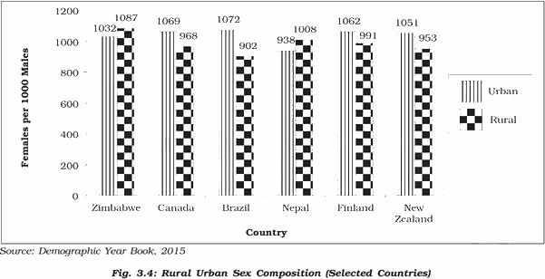
Consider the following statements with reference to most of the western countries:

1. Males outnumber females in rural areas.

2. Females outnumber the males in urban areas.

Which of the above statement(s) is/are correct?

Detailed Solution for UGC NET Paper 2 Geography Mock Test - 3 - Question 2

Rural Urban Composition

Source - NCERT

  • The rural and urban differences in sex ratio in Canada and West European countries like Finland are just the opposite of those in African and Asian countries like Zimbabwe and Nepal respectively. 
  • In Western countries, males outnumber females in rural areas and females outnumber the males in urban areas
  • In countries like Nepal, Pakistan and India the case is reversed
  • The excess of females in urban areas of U.S.A., Canada and Europe is the result of influx of females from rural areas to avail of the vast job opportunities. 
  • Farming in these developed countries is also highly mechanised and remains largely a male occupation. 
  • By contrast the sex ratio in Asian urban areas remains male dominated due to the predominance of male migration
  • Also, in countries like India, female participation in farming activity in rural areas is fairly high

Shortage of housing, high cost of living, paucity of job opportunities and lack of security in cities, discourage women from migrating from rural to urban areas.

UGC NET Paper 2 Geography Mock Test - 3 - Question 3

The following item consists of two statements, statement I and statement II. Examine these two statements carefully and select the correct answer from the code given below.

Statement I:

Summer is the favourable season for lumbering activity.

Statement II:

The Siberian region has a thriving lumbering industry.

Detailed Solution for UGC NET Paper 2 Geography Mock Test - 3 - Question 3

The Correct Answer is Option 4.

Important Points

  • Lumbering is defined as the felling of economic trees in the forest, which can be used for domestic, industrial, or commercial purposes.
  • Factors that favour lumbering :
    • Limited species forests such as coniferous forests.
    • Lumbering is normally carried out in the winter when the sap ceases to flow. This makes felling much simpler. Hence, statement I is incorrect.
  • The snow-covered ground makes logging and haulage [commercial transport of goods] a relatively easy job.
  • The logs are dragged to the rivers and float to the saw-mills downstream when the rivers thaw [unfreeze] in spring. This has greatly assisted the lumbering industry in eastern Canada and Sweden.
  • Cheap hydroelectricity for driving the saw-mills is harnessed in the mountainous uplands of North America and Europe and have greatly assisted the lumbering industry.
  • Factors hindering Lumbering :
    • High species diversity as seen in Equatorial and Tropical forests.
    • The heaviness of the tropical hardwoods makes them unable to float in rivers, thus requiring the development of various modes of transport in the forests. 
  • It is the most important occupation of the Siberian type of climate. Hence, statement II is correct.
UGC NET Paper 2 Geography Mock Test - 3 - Question 4

What is the name of the national portal developed and hosted by ISRO that provides remote sensing and GIS services?

Detailed Solution for UGC NET Paper 2 Geography Mock Test - 3 - Question 4
  • ISRO stands for Indian Space Research Organisation.
  • It operates under the Department of Space (DOS) which is directly overseen by the Prime Minister of India.
  • The chairman of ISRO acts as the executive of DOS as well.
  • ISRO is the primary agency in India to perform tasks related to space-based applications, space exploration, and the development of related technologies.
  • It is one of six government space agencies in the world that possess full launch capabilities, deploy cryogenic engines, launch extraterrestrial missions and operate large fleets of artificial satellites.

Key-Points

Bhuvan:

  • Bhuvan, is an Indian web-based utility.
  • It allows users to explore a set of map-based content prepared by the Indian Space Research Organisation.
  • The content which the utility serves is mostly restricted to Indian boundaries and is offered in 4 regional languages.
  • The content includes thematic maps related to disasters, agriculture, water resources, land cover and also processed satellite data of ISRO.
  • Bhuvan is known for its association with various sections of the Government of India to enable the use of Geospatial technology.
  • ISRO launched the beta version of Bhuvan, on August 12, 2009. 


Thus, Bhuvan is the name of the national portal developed and hosted by ISRO that provides remote sensing and GIS services.
Additional Information

GeoWeb:

  • The Environmental Geoweb Service (GeoWeb) is a service that locates, indexes, and presents geographically-referenced scientific data.
  • The Geoweb Service has been designed and developed within the EPA (Environment Protection Agency).
  • It is used by EPA scientists to perform cross-disciplinary searches for data of relevance to their work.

Edusat:

  • It is a communication satellite, launched by the Indian Space Research Organisation, to serve the educational sector. 
  • It is a man-made satellite.
  • It is the first Indian satellite built solely for serving the educational sector.
  • EDUSAT is primarily meant for providing connectivity to school, college and higher levels of education for better academic outcomes.
  • Launched successfully by GSLV-F01 on 20-9-2004 from Satish Dhawan Space Centre (SDSC), Sriharikota.
  • This satellite is meant for distant classroom education from the school level to higher education.
UGC NET Paper 2 Geography Mock Test - 3 - Question 5

Which of the following is NOT a theme that influenced Ratzel's work?

Detailed Solution for UGC NET Paper 2 Geography Mock Test - 3 - Question 5

Answer: 2) Cultural Diffusion.

Friedrich Ratzel was a German geographer, ethnologist, and anthropologist who is considered to be the father of political geography. He was influenced by various themes and ideas during his lifetime, some of which had a significant impact on his work.

Key Points

  •  Among the options provided, cultural diffusion is the theme that did NOT influence Ratzel's work.
  • Cultural diffusion refers to the spread of cultural traits, such as ideas, beliefs, and practices, from one group of people to another.
  • While Ratzel was interested in the relationship between culture and geography, his primary focus was on the role of physical factors, such as climate and topography, in shaping human societies.

Additional Information 

  • The other three options, association and organization, struggle and natural selection, and historical development, were all themes that influenced Ratzel's work.
  • Ratzel believed that human societies were organized and functioned in a similar way to biological organisms, and he used Darwin's theory of evolution to explain the development of human societies.
  • He also emphasized the importance of historical factors in shaping the present-day distribution of human populations and cultures.

Therefore, the correct answer is option 2) Cultural diffusion. Ratzel's work was primarily influenced by themes such as association and organization, struggle and natural selection, and historical development, rather than cultural diffusion.

UGC NET Paper 2 Geography Mock Test - 3 - Question 6
Given below are two statements. One is labelled as Assertion (A) and the other is labelled as Reason (R).

Assertion- Richard Hartshorne attempts to capture difference between systematic geography and regional geography.

Reasoning- Regional geography is study of any two-dimensional area of interest.

Select the correct answer from options given below :

Detailed Solution for UGC NET Paper 2 Geography Mock Test - 3 - Question 6

Richard Hartshorne was two persistent in noting a distinction within the fields between what he termed “systematic geography” and “regional geography”. Regional geography of Hartshorne is the study of all the feature of a given region, any two-dimensional area of interest.

Thus, the Correct answer is A.

UGC NET Paper 2 Geography Mock Test - 3 - Question 7
Given below are two statements- one is labelled as Assertion (A) and the other is labelled as Reason (R):

Assertion(A)- Exogenous processes are responsible for gradation.

Reason(R)- Weathering and erosion is often described as the essential phase in the denudation process of landscapes.

Choose the correct option:

Detailed Solution for UGC NET Paper 2 Geography Mock Test - 3 - Question 7

Gradation is nothing but the erosion of a rugged landscape into a level land. The gradation is achieved because of Degradation and Aggradation. Weathering and erosion have the capability to convert hard massive rocks into finer material. Hence for this, Weathering is often known as the first essential phase in the denudation or gradation of landscapes as it prepares the rock materials for transportation, depositional processes as well as provides for the degradation of landscapes.

UGC NET Paper 2 Geography Mock Test - 3 - Question 8
The statistical methods for the study of distribution and pattern of settlement is known as:
Detailed Solution for UGC NET Paper 2 Geography Mock Test - 3 - Question 8

Nearest neighbor analysis is the method used to study the distance between the nearest two points. It helps in studying the pattern of distribution of a settlement that is clustered, random or regular. Nearest neighbor analysis will produce a result between 0 and 2.5.

Thus, the Correct answer is C.

UGC NET Paper 2 Geography Mock Test - 3 - Question 9
What is known as doldrums?
Detailed Solution for UGC NET Paper 2 Geography Mock Test - 3 - Question 9

The correct answer is Equilateral low-pressure Belts.

Important Points

  • Doldrums, also called equatorial low-pressure belts are equatorial regions of light ocean currents and winds within the intertropical convergence zone (ITCZ), a belt of converging winds and rising air encircling Earth near the Equator. Hence, option 1 is the correct answer.
  • The northeast and southeast trade winds meet there; this meeting causes air uplift and often produces clusters of convective thunderstorms. They occur along the Equator in the Indian and western Pacific oceans and slightly north of the Equator off the African and Central American west coasts. The crews of sailing ships dreaded the doldrums because their ships were often becalmed there; the designation for the resultant state of depression was apparently thus extended to these geographic regions themselves.
UGC NET Paper 2 Geography Mock Test - 3 - Question 10

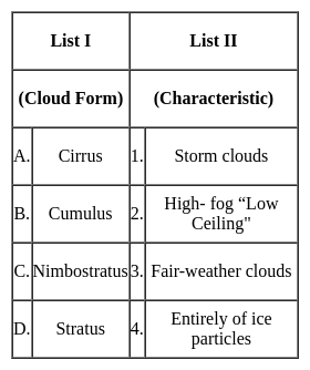
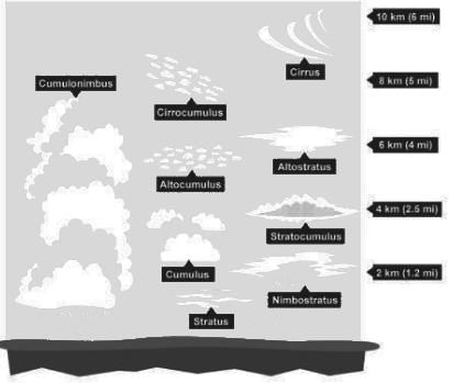
Match List I with List II and select the correct answer using the code given below the Lists :

Detailed Solution for UGC NET Paper 2 Geography Mock Test - 3 - Question 10

The correct answer is option 3.

Key Points

  • Cirrus clouds
    • Formed at high altitudes (8,000 - 12,000m). 
    • They are thin and detached clouds having a feathery appearance.
    • They are always white in color.
    • Cirrus clouds are delicate, feathery clouds that are made mostly of ice crystals.
    • Their wispy shape comes from wind currents which twist and spread the ice crystals into strands.
  • Cumulus
    • ​Formed at a height of 4,000 - 7,000 m.
    • They can appear as low as 300ft above the ground.
    • They exist in patches and can be seen scattered here and there.
    • These clouds look like fluffy, white cotton balls in the sky. They have a flat base
  • Nimbostratus
    • Nimbus is known as a rainstorm within the Latin language.
    • Low-level Clouds, resulting from thickening Altostratus.
    • These are dark, gray clouds that seem to fade into falling rain or snow.
    • They are so thick that they often blot out the sunlight.
  • Stratus
    • These are low Clouds (less than 6,500 feet).
    • These are layered clouds covering large portions of the sky. 
    • Stratus clouds often look like thin, white sheets covering the whole sky. Since they are so thin, they seldom produce much rain or snow.
    • Sometimes, in the mountains or hills, these clouds appear to be fog.

​​Hence, the correct answer is option 3.

UGC NET Paper 2 Geography Mock Test - 3 - Question 11

Consider the following -

1. Methane

2. Nitrous Oxide

3. Halons

Which of the above is/are responsible for depletion of stratospheric ozone?

Detailed Solution for UGC NET Paper 2 Geography Mock Test - 3 - Question 11

The correct answer is 1, 2 and 3.

Key Points

  • Ozone layer depletion the reduction of the amount of ozone in the stratosphere.
    • It occurs when chlorine and bromine atoms come into contact with ozone in the stratosphere, they destroy ozone molecules.
    • Ozone-depleting substances (ODS), which include chlorofluorocarbons (CFCs) and hydrofluorocarbons (HCFCs), were once used widely in refrigerants, insulating foams, solvents, and other applications.
    • Other chemicals that damage the ozone layer include methyl bromide (used as a pesticide), halons (used in fire extinguishers), and methyl chloroform (used as a solvent in industrial processes). 
  • Methane can react with other gases to form water vapor, which then breaks down into other chemicals that destroy ozone.
  •  Nitrous Oxide affect Ozone depletion.
    • The compound reacts with high-energy oxygen atoms to produce a deadlier compound, nitric oxide (NO). This then goes on to destroy ozone, a molecule made up of three oxygen atoms.
  • Halons are ozone depleting substances whose production and consumption is controlled under the Montreal Protocol.
    • All halons contain bromine which is 40-100 times more effective at destroying ozone than chlorine.

Additional Information

  • Stratosphere
    •  It is the second layer of the atmosphere found above the troposphere.
    • It extends up to 50 km of height.
    • This layer provides some advantages for flight because it is above stormy weather and has steady, strong, horizontal winds.
    • The ozone layer is found in this layer. The ozone layer absorbs UV rays and safeguards the Earth from harmful radiation.
    • Stratopause separates stratosphere and mesosphere.​ 
UGC NET Paper 2 Geography Mock Test - 3 - Question 12
Who emphasized the need for unbalanced growth in the field of development economics?
Detailed Solution for UGC NET Paper 2 Geography Mock Test - 3 - Question 12

There are two theories concerning the strategy of economic development:

  1. Theory of Balanced Growth: According to Rodan, Nurkse, and Lewis, these economies should make simultaneous investments in all sectors to achieve balanced growth.
  2. Theory of Unbalanced Growth: According to Hirschman, Singer, Fleming, these economies should create a situation of unbalance by making a large investment in any one sector.

Key Points

Hirschman’s View:

  • Albert Hirschman, an American Economic Professor, explained the economic growth process in terms strikingly similar to those of Myrdal.
  • Hirschman felt that “ Interregional inequality of growth is an inevitable concomitant and condition of growth itself”.
  • Hirschman explained his concept with the help of two terms i.e.,” Trickling-down effect” and Polarization effect”.
    • Trickling down effect (analogous to Myrdal’s Spread effect)
    • Polarization effect (analogous to backwash effect).
  • Some economists criticized Hirschman’s theory of “economic transmission” - for having created terminological confusion for the terms already accepted in the scientific language

Hence, A. Hirschman emphasized the need for unbalanced growth in the field of development economics.

UGC NET Paper 2 Geography Mock Test - 3 - Question 13
Which type of data defines location, size, shape and orientation of objects using line?
Detailed Solution for UGC NET Paper 2 Geography Mock Test - 3 - Question 13

Explanation:

There are two types of Data that can be used in GIS – Spatial and Attribute data

Geospatial data

  • It is time-based data that is related to a specific location on the Earth's surface.
  • It can provide insights into relationships between variables and reveal patterns and trends.
  • It uses discrete points, lines, and/or areas corresponding to discrete objects

Attribute Data:

  • Attribute data are the information linked to the geographic features (spatial data) that describe features.
  • It gives graphic information associated with a point, line, or area element in a GIS.
  • It is used to describe the feature that we want to map.
UGC NET Paper 2 Geography Mock Test - 3 - Question 14
The Pass, which is situated at the highest elevation among the given options is - 
Detailed Solution for UGC NET Paper 2 Geography Mock Test - 3 - Question 14

The correct answer is 'Nathu La pass'.

The heights of given passes is as follows-

  • Nathu La Pass - 4310 m
  • Rohtang Pass - 3978 m
  • Zoji La Pass - 3528 m
  • Khyber Pass - 1070 m

Important Points

Some important passes of India are as follows-

  •  Nathu La Pass - connects Sikkim to China
  • Shipki La Pass - connects Himachal and Tibet
  • Jelep La Pass- connects Sikkim to Lhasa
  • Khardung La Pass- connects Leh and Siachen Glacier
  • Aghil Pass - connects Ladhak with Xinjiang province of China
  • Lanak La- connects Ladhak and Lhasa
UGC NET Paper 2 Geography Mock Test - 3 - Question 15
Visibility is reduced due to the presence of high levels of pollutants, especially in cold weather when water from the air also condenses. It is known as _____
Detailed Solution for UGC NET Paper 2 Geography Mock Test - 3 - Question 15

The correct answer is Fog.

Key Points

  • The suspended particles can be undispersed carbon particles or substances called hydrocarbons.
    • The presence of high levels of all these pollutants leads to reduced visibility, especially in cold weather when water also condenses from the air.
    • This is known as smog and is a clear sign of air pollution.

Additional Information

  • Mist is a phenomenon caused by tiny droplets of water suspended in cold air, usually by condensation. Physically, this is an example of dispersion.
  • Smoke is a collection of airborne particles and gases that are emitted when a material undergoes combustion or pyrolysis, together with amounts of air that have entered or otherwise mixed into the mass.
  • Frost is a thin layer of ice on a solid surface formed by the contact of water vapor in the cold atmosphere above a solid surface with a temperature below the freezing point, and the resulting conversion of water vapor to ice as water.
UGC NET Paper 2 Geography Mock Test - 3 - Question 16

Match the following correctly:

Detailed Solution for UGC NET Paper 2 Geography Mock Test - 3 - Question 16

The correct answer is (a) - (iii), (b) - (iv), (c) - (ii), (d) - (i).
Key Points

UGC NET Paper 2 Geography Mock Test - 3 - Question 17

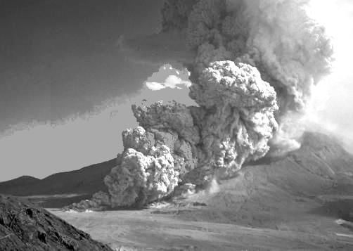
The dust and ash material hurled from the volcanoes are termed as:

Detailed Solution for UGC NET Paper 2 Geography Mock Test - 3 - Question 17

The correct answer is Pyroclastic.

Key Points

  • Pyroclastic flows contain a high-density mix of hot lava blocks, pumice, ash, and volcanic gas. They move at very high speed down volcanic slopes, typically following valleys.
  • Pelean and Plinian eruptions are the most dangerous and explosive of the eruption types.
  • Pelean eruptions are named for the catastrophic eruption on the island of Martinique in the Caribbean Sea in 1902. The eruption and the pyroclastic flow that followed killed 29,000 people almost instantly.

Additional Information

  • Volcanoes:
    • A volcano is a vent or fissure in Earth’s crust through which lava, ash, rocks, and gases erupt.
  • The other types of volcanoes are Shield Volcanoes and Composite Volcanoes.
  • Shield volcanoes:
    • These are the largest of all the volcanoes on the earth.
    • These volcanoes are made up of basalt.
    • Eg: Hawaiian shield volcanoes.
  • Flood Basalt volcanoes:
    • These volcanoes discharge highly fluid lava that flows for long distances.
    • Most parts of the world are covered by thick basalt lava flows.
UGC NET Paper 2 Geography Mock Test - 3 - Question 18

The temperature-depth profile of the ocean is an interesting topic of study. Which of the following statements is/are incorrect regarding this?

1. About 90 per cent of the total volume of water is found below the thermocline in the deep ocean.

2. The thermocline layer is characterised by a rapid decrease in temperature with increasing depth.

3. The highest temperature of the ocean waters is recorded at the equator.

Identify the correct answer from the codes given below.
Detailed Solution for UGC NET Paper 2 Geography Mock Test - 3 - Question 18
  • The temperature-depth profile shows a boundary region between the surface waters of the ocean and the deeper layers. This boundary region, from where there is a rapid decrease of temperature, is called the thermocline.
  • About 90 per cent of the total volume of water is found below the thermocline in the deep ocean. Hence Statement 1 is correct.
  • The thermocline layer is 500 to 1000m thick and is characterised by rapid decrease in temperature with increasing depth. Hence Statement 2 is correct.
  • The rate of decrease of temperature with increasing latitude is generally 0.5°C per latitude.
  • The oceans in the northern hemisphere record relatively higher temperatures than in the southern hemisphere. The highest temperature is not recorded at the equator but slightly towards north of it. Hence Statement 3 is incorrect.
UGC NET Paper 2 Geography Mock Test - 3 - Question 19

Which of the following is true about Tropical Rain forest?

(A) These forest are called evergreen forests.

(B) The trees in these forests shed their leaves at different times of the year.

(C) Sal, Teak and Shisham are important trees of these forests.

(D) These forests are called monsoon forests.

Choose the correct option

Detailed Solution for UGC NET Paper 2 Geography Mock Test - 3 - Question 19

The correct answer for the given question is option 1, which includes options (A) and (B).

Key Points

  • Tropical rainforests are called evergreen forests because they have high annual rainfall and consistent temperature, which allows the trees to retain their leaves throughout the year.
  • The trees in tropical rainforests do not shed their leaves at the same time, but rather at different times of the year, which is known as deciduousness.
  • Sal, Teak, and Shisham are not important trees in tropical rainforests. These trees are commonly found in dry deciduous forests and savannas.
  • Tropical rainforests are not called monsoon forests. Monsoon forests are a type of tropical seasonal forest that experiences a distinct wet and dry season.

Additional Information

Additional information about the other options mentioned in the question are: - Option 2, which includes options (A) and (C), is incorrect because Sal, Teak, and Shisham are not important trees in tropical rainforests. - Option 3, which includes options (B) and (D), is incorrect because tropical rainforests are not called monsoon forests. - Option 4, which includes options (C) and (D), is incorrect because Sal, Teak, and Shisham are not important trees in tropical rainforests and tropical rainforests are not called monsoon forests. Key points for the correct options are: - Tropical rainforests are called evergreen forests because they have high annual rainfall and consistent temperature. - The trees in tropical rainforests do not shed their leaves at the same time, but rather at different times of the year. - Tropical rainforests are characterized by high biodiversity and complex ecosystems. - Tropical rainforests are vital for regulating the global climate and providing ecosystem services such as carbon storage, water cycling, and habitat for wildlife.

UGC NET Paper 2 Geography Mock Test - 3 - Question 20
Concentric zone theory was propounded by whom ?
Detailed Solution for UGC NET Paper 2 Geography Mock Test - 3 - Question 20

Concentric zone theory was propounded by Ernest Burgess (Chicago School of Sociology) during early 20th century.

Key Points

  • Concentric Zone Theory
    • Put forth by Ernest Burgess in 1925 based on his observation of many American cities, especially Chicago.
    • Showed a correlation between the geography, urban land use patterns and distribution of social groups.
    • Identified following zones: Central Business District, Zone of Transition, Working Class zone, Residential zone and Commuter zone.

Additional Information

  • Ernest Burgess
    • Associated with Chicago school of Urban Sociology.
    • Co-authored textbook "Introduction to the Science of Sociology" with Robert E. Park.
      • also known as 'Bible of Sociology' for it was quite comprehensive.
      • Presented the observation and reflection of thinkers who viewed society from their distinct vantage point.
    • In "The City", he along with Robert Park and Mckenzie, conceptualised city as concentric zones.
  • Robert Park
    • ​was instrumental in formation of Chicago school of Urban Sociology.
    • coined the phrase 'Human Ecology'.
    • Applied concepts from Biology to Urban Sociology.
    • Propunded Urban Ecological perspective to understand urban life.​
  • Kingsley Davis
    • was a demographer and sociologist of international repute.
    • Coined the terms 'overurbanization', 'population explosion' and 'zero population growth'.
    • Along with Wilbert E. Moore he wrote an article titled "Some Principles of Stratification".
    • His emphasised on 'functional pre-requisites', 'role allocation and performance'.
  • William F. Whyte
    • pioneered ethnographic study and participant observation method in urban sociology.
    • famous for his study of street gang culture of Boston.
    • Later he published a book on this titled "Street Corner Society" (1993).
    • Another important work by him is "Participant Observer: An Autobiography" (1994).
UGC NET Paper 2 Geography Mock Test - 3 - Question 21
Federalism does not involve which of the following?
Detailed Solution for UGC NET Paper 2 Geography Mock Test - 3 - Question 21

The correct answer is the Centralization of power.Important Points

  • Federalism is a system of government in which the same territory is controlled by two levels of government. Generally, an overarching national government is responsible for the broader governance of larger territorial areas, while the smaller subdivisions, states, and cities govern the issues of local concern. Both the national government and the smaller political subdivisions have the power to make laws and both have a certain level of autonomy from each other.

Key Points

  • Federalism the political system itself must reflect the constitution by actually diffusing power among several substantially self-sustaining centers. Such a diffusion of power may be termed noncentralization.
  • Noncentralization is a way of ensuring in practice that the authority to participate in exercising political power cannot be taken away from the general or the state governments without common consent.
  • The constituent polities in a federal system must be fairly equal in population and wealth or else balanced geographically or numerically in their inequalities.
  • Federalism is a combined or compound mode of government that combines a general government (the central or "federal" government) with regional governments (provincial, state, cantonal, territorial, or other sub-unit governments) in a single political system, dividing the powers between the two.
  • Federalism in the modern era was first adopted in the unions of states during the Old Swiss Confederacy.
  • Federalism differs from confederalism, in which the general level of government is subordinate to the regional level, and from devolution within a unitary state, in which the regional level of government is subordinate to the general level. It represents the central form in the pathway of regional integration or separation, bounded on the less integrated side by confederalism and on the more integrated side by devolution within a unitary state.
  • Examples of a federation or federal province or state include Argentina, Australia, Belgium, Bosnia & Herzegovina, Brazil, Canada, Germany, India, Iraq, Malaysia, Mexico, Micronesia, Nepal, Nigeria, Pakistan, Russia, Switzerland, the United Arab Emirates, and the United States.
UGC NET Paper 2 Geography Mock Test - 3 - Question 22

Which of the following statement is correct related to the rocks?

1. Rocks formed out of solidification of magma and lava and are known as igneous rocks.

2. Acidic rocks does not constitute the sial portion of the crust.

Detailed Solution for UGC NET Paper 2 Geography Mock Test - 3 - Question 22

The correct answer is 1 only.

Key Points

Igneous Rocks or Primary Rocks

  • The solidification of magma formed the first rocks on earth.
  • Rocks formed out of solidification of magma (molten rock below the surface) and lava (molten rock above the surface) and are known as igneous or primary rocks. Hence, Statement 1 is correct.
  • Having their origin under conditions of high temperatures the igneous rocks are unfossiliferous.
  • Granite, gabbro, and basalt are some examples of igneous rocks.
  • There are three types of igneous rocks based on the place and time taken in cooling of the molten matter, plutonic rocks, volcanic rocks and intermediate rocks.
  • There are two types of rocks based on the presence of acid-forming radicals, silicon, acidic rocks and basic rocks.

Acidic Rocks

  • Acidic rocks are characterised by a high content of silica (quartz and feldspar) — up to 80 per cent.
  • The rest is divided among aluminium, alkalis, magnesium, iron oxide, lime etc.
  • These rocks have a lesser content of heavier minerals like iron and magnesium. Hence, they are less dense and are lighter in colour than basic rocks.
  • These rocks constitute the sial portion of the crust. Hence, Statement 2 is not correct.
  • Due to the excess of silicon, acidic magma cools fast, and it does not flow and spread far away.
  • High mountains are formed of this type of rock.
  • Add rocks are hard, compact, massive and resistant to weathering.
  • Granite, quartz and feldspar are typical examples.

Additional Information

Sedimentary rocks

  • It is formed by lithification ― consolidation and compaction of sediments.
  • Hence, they are layered or stratified of varying thicknesses. Example: sandstone, shale etc.
  • Sediments are a result of denudation (weathering and erosion) of all types of rocks.
  • These types of rocks cover 75 per cent of the earth’s crust but volumetrically occupy only 5 per cent (because they are available only in the upper part of the crust).
  • Ice deposited sedimentary rocks are called till or tillite. Wind-deposited sediments are called loess.
UGC NET Paper 2 Geography Mock Test - 3 - Question 23

Which of the following statements about minerals are correct?

(A) Minerals are created by natural processes without any human interference

(B) Mica and chromite are nonferrous minerals

(C) Minerals lying at shallow depths are taken out through open cast mining

(D) Minerals are a non-renewable resource

Detailed Solution for UGC NET Paper 2 Geography Mock Test - 3 - Question 23

A naturally occurring substance that has a definite chemical composition is a mineral.Important Points

  • Minerals are formed in different types of geological environments, under varying conditions
  • They are created by natural processes without any human interference.
  • They can be identified on the basis of their physical properties such as colour, density, hardness and chemical property such as solubility.
  • on the basis of composition, minerals are classified mainly as metallic and non-metallic minerals.
  • Metallic minerals contain metal in raw form. Metals are hard substances that conduct heat and electricity and have a characteristic lustre or shine. Iron ore, bauxite, manganese ore
    • Metallic minerals may be ferrous or non-ferrous.
    • Ferrous minerals like iron ore, manganese and chromite contain iron
    • A non-ferrous mineral does not contain iron but may contain some other metal such as gold, silver, copper or lead.
  • Non-metallic minerals do not contain metals. Limestone, mica and gypsum are examples of such minerals. The mineral fuels like coal and petroleum are also non-metallic minerals.
  • Minerals can be extracted by mining, drilling or quarrying.
  • Minerals are considered nonrenewable because they take a very long time to form (millions of years). This implies that once they are used up, they cannot get back within a short period.
  • The process of taking out minerals from rocks buried under the earth’s surface is called mining. Minerals that lie at shallow depths are taken out by removing the surface layer; this is known as open-cast mining.
  • Minerals occur in different types of rocks. Some are found in igneous rocks, some in metamorphic rocks while others occur in sedimentary rocks.

So, the above points shows that A, C, and D satisfy the minerals.

UGC NET Paper 2 Geography Mock Test - 3 - Question 24
The spread of cultural traits from one region to other is called:
Detailed Solution for UGC NET Paper 2 Geography Mock Test - 3 - Question 24

The correct answer is Diffusion.

Key Points

  • The spread of cultural traits from one region to another is called cultural diffusion.
  • Cultural diffusion often occurs when people move from one place to another.
  • It is the geographical and social spread of the different aspects of one more culture to different ethnicities, religions, nationalities, regions, etc.

Additional Information

UGC NET Paper 2 Geography Mock Test - 3 - Question 25
Consider the following statements about ecological factors:-

i. Light and temperature are direct ecological factors.

ii. Indirect factors include soil structure, altitude, wind and slope.

iii. Edaphic factors and biotic factors can be included in physical factors.

Choose the correct option from below:

Detailed Solution for UGC NET Paper 2 Geography Mock Test - 3 - Question 25

 The environment is an amalgamation of various features called factors. These are the product of forces and process of nature and are universal and inherent all over the earth. These factors are classified into two groups direct factors and indirect factors. The direct factors are light, temperature, soil air, water etc. and indirect factors include soil structure, soil organisms, altitude, wind, slope, etc.

Thus, the correct answer is D.

UGC NET Paper 2 Geography Mock Test - 3 - Question 26

Deltas are formed where the shores are free of

Detailed Solution for UGC NET Paper 2 Geography Mock Test - 3 - Question 26

Deltas are formed where the shores are free of hard rocks. When a river reaches a lake or the sea the water slows down and loses the power to carry sediment . The sediment is dropped at the mouth of the river. Some rivers drop so much sediment that waves and tides can't carry it all away. It builds up in layers forming a delta.

UGC NET Paper 2 Geography Mock Test - 3 - Question 27
A city which has direct effect on global affairs in social, economic, political and cultural terms is
Detailed Solution for UGC NET Paper 2 Geography Mock Test - 3 - Question 27

The word global city was first used by Saskia Sassen in the paper ‘The Global City’ for the cities of London, New York and Tokyo. The global cities have a tangible and direct impact on the cultural, socio-economic and political scenario of the world. Emerging cities like Sydney, Mexico City, Frankfurt are looking to emerge as global cities.

UGC NET Paper 2 Geography Mock Test - 3 - Question 28

Given below are two statements. One is labelled as Assertion (A) and the other is labelled as Reason (R).

Assertion (A): Development in ICT has led to increase in technical field of education in India.

Reason (R) : There has been increase in investment in ICT sector in India.

Select the correct answer from options given below:

Detailed Solution for UGC NET Paper 2 Geography Mock Test - 3 - Question 28

The Information and communication is a sector developing at a stupendous rate globally. The Foreign Direct Investment in India has been done most in the ICT sector. Thus, investment in the area has increased considerably. This has led to requirement of skilled workforce for ICT. So, there has been progress in technical education in India, specifically ICT sector due to enormous employment opportunities. Thus, (R) is the correct explanation of (A).

UGC NET Paper 2 Geography Mock Test - 3 - Question 29

For the first time, over 3000 years ago the _____ prepared feasible maps, showing particularly boundaries with a view of making proper assessment of revenue.

Detailed Solution for UGC NET Paper 2 Geography Mock Test - 3 - Question 29

For the first time, over 3000 years ago the Indians prepared feasible maps, showing particularly boundaries with a view of making proper assessment of revenue.

UGC NET Paper 2 Geography Mock Test - 3 - Question 30

How the Himalayas are formed?

Detailed Solution for UGC NET Paper 2 Geography Mock Test - 3 - Question 30

The Himalayan mountain range and Tibetan plateau have formed as a result of the collision between the Indian Plate and Eurasian Plate which began 50 million years ago and continues today. 225 million years ago (Ma) India was a large island situated off the Australian coast and separated from Asia by the Tethys Ocean.

View more questions
92 docs|125 tests
Information about UGC NET Paper 2 Geography Mock Test - 3 Page
In this test you can find the Exam questions for UGC NET Paper 2 Geography Mock Test - 3 solved & explained in the simplest way possible. Besides giving Questions and answers for UGC NET Paper 2 Geography Mock Test - 3, EduRev gives you an ample number of Online tests for practice
Download as PDF