KTET Exam  >  KTET Tests  >  Kerala SET Mock Test Series 2025  >  Kerala SET Paper 2 Mock Test - 4 (Geography) - KTET MCQ

Kerala SET Paper 2 Mock Test - 4 (Geography) - KTET MCQ


Test Description

30 Questions MCQ Test Kerala SET Mock Test Series 2025 - Kerala SET Paper 2 Mock Test - 4 (Geography)

Kerala SET Paper 2 Mock Test - 4 (Geography) for KTET 2025 is part of Kerala SET Mock Test Series 2025 preparation. The Kerala SET Paper 2 Mock Test - 4 (Geography) questions and answers have been prepared according to the KTET exam syllabus.The Kerala SET Paper 2 Mock Test - 4 (Geography) MCQs are made for KTET 2025 Exam. Find important definitions, questions, notes, meanings, examples, exercises, MCQs and online tests for Kerala SET Paper 2 Mock Test - 4 (Geography) below.
Solutions of Kerala SET Paper 2 Mock Test - 4 (Geography) questions in English are available as part of our Kerala SET Mock Test Series 2025 for KTET & Kerala SET Paper 2 Mock Test - 4 (Geography) solutions in Hindi for Kerala SET Mock Test Series 2025 course. Download more important topics, notes, lectures and mock test series for KTET Exam by signing up for free. Attempt Kerala SET Paper 2 Mock Test - 4 (Geography) | 120 questions in 120 minutes | Mock test for KTET preparation | Free important questions MCQ to study Kerala SET Mock Test Series 2025 for KTET Exam | Download free PDF with solutions
Kerala SET Paper 2 Mock Test - 4 (Geography) - Question 1

Consider the following States:

1. Karnataka

2. Andhra Pradesh

3. Goa

4. Rajasthan 

Which of the above are the major maize-producing states?

Detailed Solution for Kerala SET Paper 2 Mock Test - 4 (Geography) - Question 1

The correct answer is Option 4.

  • In India, maize is grown in Karnataka, Madhya Pradesh, Maharashtra, Telangana, Rajasthan, Tamil Nadu, Bihar, Uttar Pradesh, and Gujarat.​

Key PointsMaize

  • In India, maize is the third most important food crop after rice and wheat.
  • Maize in India contributes nearly 9% of the national food basket.
  • In addition to staple food for human beings and quality feed for animals,
  • It serves as a basic raw material ingredient in industrial products, including-
    • starch, oil, protein, alcoholic beverages, food sweeteners, pharmaceutical, cosmetic, film, textile, gum, package and paper industries, etc.
  • The predominant maize-growing states that contribute more than 80 % of the total maize production are:
    •  Andhra Pradesh (20.9 %), Karnataka (16.5 %), Rajasthan (9.9 %), Maharashtra (9.1 %), Bihar (8.9 %), Uttar Pradesh (6.1 %), Madhya Pradesh (5.7 %), Himachal Pradesh (4.4 %).
  •  Apart from these states, maize is also grown in Jammu and Kashmir, and North-Eastern states.
  • Hence, maize has emerged as an essential crop in non-traditional regions.
  • State like Andhra Pradesh which ranks 5th in the area (0.79 m ha) has recorded the highest production (4.14 mt) and productivity (5.26 t/ha ) in the country.

Additional InformationRequirement for maize production:

  • It is a Kharif crop.
  • Irrigation facilities, usage of fertilizers, and usage of High Yielding Variety (HYV) seed contributed to the massive increase in maize production in India.
  • Maize grows well in temperatures ranging from 21°C to 27°C.
  • It grows well in old alluvial soil.
  • maize is a warm-weather crop
  • it cannot survive freezing
  • Therefore, the best soils for maize growth should have a sufficient ability to hold water and efficient drainage.
Kerala SET Paper 2 Mock Test - 4 (Geography) - Question 2

Who in 1905 clearly expressed the logical arguments concerning the place of the Earth’s body in the field of Geography?

Detailed Solution for Kerala SET Paper 2 Mock Test - 4 (Geography) - Question 2

Hettner in 1905 clearly expressed the logical arguments concerning the place of the Earth’s body in the field of Geography.

Key Points

Alfred Hettner (August 6, 1859 – August 31, 1941):

  • Alfred Hettner was a German geographer.
  • He is known for his concept of chorology, the study of places and regions, a concept that influenced both Carl O. Sauer and Richard Hartshorne.
  • Apart from Europe, his fieldwork concentrated mainly on Colombia, Chile, and Russia.
  • Alfred Hettner, who obtained his PhD from the University of Strasbourg, was also a pupil of Ferdinand von Richthofen and Friedrich Ratzel in Leipzig—where he obtained his habilitation.
  • His book Europe was published in 1907.
  • According to him, geography is a chorological science or it is a study of regions.
  • In his view, geography was fundamentally chorology, or the study of geographic distributions over the Earth’s surface. It was concerned with human interconnection and interaction with the natural environment, but it should also take into account the arrangement, by area, of the Earth’s physical phenomena. The study of local differences in phenomena over the Earth’s surface was the keynote of this concept.
  • Hettner rejected the view that geography could be either general or regional. Geography, like other fields of learning, must deal in both unique things (regional geography) and with the universal (general geography), but the study of regions — especially in the form of his Länderkunde approach — is the main field of geography.
  • For more than 40 years Hettner’s principal medium for disseminating his ideas on the scope and methodology of geography was the influential Geographische Zeitung (“Geographical Journal”), first published in 1899.
  • The first volume of his Grundzüge der Länderkunde (1907; “Foundations of Regional Geography”) dealt with Europe, but its companion volume, on other regions, did not appear until 1924.
  • He also wrote Vergleichende Länderkunde, 4 vol. (1933–35; “Comparative Regional Geography”).
  • One of the major works of geographic literature, the 11-volume Handbuch der Geographischen Wissenschaft (“Handbook of Geographical Science”), completed in 1940, was his conception.
  • Hettner supervised, among others, the PhDs of Oskar Schmieder, Friedrich Metz, and Heinrich Schmitthenner.
Kerala SET Paper 2 Mock Test - 4 (Geography) - Question 3

Biosphere reserves are:

i) area comprising terrestrial, marine and coastal ecosystems.

ii) monitored by national governments.

iii) areas where threatened animals and plants are kept in their habitat.

iv) wildlife sanctuaries.

Choose the correct statements from the options given below:

Detailed Solution for Kerala SET Paper 2 Mock Test - 4 (Geography) - Question 3

Biosphere reserves are ‘learning places for sustainable development’.

  • They are sites for testing interdisciplinary approaches to understanding and managing changes and interactions between social and ecological systems, including conflict prevention and management of biodiversity.
  • They are places that provide local solutions to global challenges.
  • Biosphere reserves include terrestrial, marine, and coastal ecosystems. Each site promotes solutions reconciling the conservation of biodiversity with its sustainable use.
  • Biosphere reserves are nominated by national governments and remain under the sovereign jurisdiction of the states where they are located.
  • Biosphere Reserves are designated under the intergovernmental MAB Programme by the Director-General of UNESCO following the decisions of the MAB International Coordinating Council (MAB ICC). 
  • Their status is internationally recognized. Member States can submit sites through the designation process.

Biosphere Reserves involve local communities and all interested stakeholders in planning and management. They integrate three main "functions":

  1. Conservation of biodiversity and cultural diversity
  2. Economic development that is socio-culturally and environmentally sustainable
  3. Logistic support, underpinning development through research, monitoring, education, and training

These three functions are pursued through the Biosphere Reserves' three main zones: Core area, Buffer zones, and Transition area.

Hence, Biosphere reserves are areas comprising terrestrial, marine and coastal ecosystems and monitored by national governments.

Kerala SET Paper 2 Mock Test - 4 (Geography) - Question 4
When was the Integrated Rural Development Programme launched?
Detailed Solution for Kerala SET Paper 2 Mock Test - 4 (Geography) - Question 4

The Integrated Rural Development Program (IRDP) was launched by the Government of India during the financial year of 1978 and implemented during 1980. The main motto of the program was to provide employment opportunities to the poor community as well as opportunities to develop their skill sets so as to improve their living conditions.

Kerala SET Paper 2 Mock Test - 4 (Geography) - Question 5
______ is an equatorial belt of low atmospheric pressure where the trade winds converge.
Detailed Solution for Kerala SET Paper 2 Mock Test - 4 (Geography) - Question 5

The correct answer is Doldrums.

  • Doldrums is an equatorial belt of low atmospheric pressure where the trade winds converge.

Key Points

Moraine

  • Moraines are distinct ridges or mounds of debris that are directly laid down by a moving glacier. This material is usually soil and rock.
  • Moraines only show up in places that have, or used to have glaciers.
  • Glaciers are extremely large, moving rivers of ice.
  • Glaciers shape the landscape in a process called glaciation.
  • Glaciation can affect the land, rocks, and water in an area for thousands of years. That is why moraines are often very old.

La Nina

  • La Nina is a climate pattern that describes the cooling of surface ocean waters along the tropical west coast of South America.
  • La Nina is the counterpart of El Nino.
  • La Lina means Little Girl in Spanish.
  • La Lina occurs at irregular intervals of about two to seven years.
  • La Niña is caused by a build-up of cooler-than-normal waters in the tropical Pacific, the area of the Pacific Ocean between the Tropic of Cancer and the Tropic of Capricorn.
  • Unusually strong, eastward-moving trade winds and ocean currents bring this cold water to the surface, a process known as upwelling.

El Nino

  • El Nino is a climate pattern that describes the unusual warming of surface waters in the eastern tropical Pacific Ocean.
  • El Nino means Christ child or Littel Boy in Spanish
  • During the time of El Nino, the trade winds weaken and warm water pushed back east towards the coast of Latin American countries.
  • El Nino can affect our weather significantly and trade winds.
  • El Nino has a strong effect on marine life off the Pacific coast.

Additional Information

  • Atmospheric Pressure belts are seasonally identical horizontal pressure variations created in the earth's atmosphere just above the earth's surface due to seasonal and spatial variation of energy received by the earth at different places.
  • There are seven pressure belts on the earth's surface. They are the Equatorial Low, the two Subtropical highs, the two Subpolar lows, and the two Polar highs. Except for the Equatorial low, the others form matching pairs in the Northern and Southern Hemispheres.

Equatorial Low-Pressure Belts

  • It is located on either side of the North and South of the Equator in a zone extending from 0o to 5o.
  • It is thermally induced because of the intense heating of the ground by the vertical rays of the sun.
  • It represents the zone convergence of North-East and South-East trade winds. This convergence zone is characterized by light and feeble winds and because of the frequent calm conditions, this belt is also called a belt of calm or doldrums.

Subtropical High-Pressure Belts

  • It extends between 30o to 35o both the hemisphere
  • It is not thermally induced but dynamically induced as it owes its origin to the rotation of the earth and sinking and settling down of winds.
  • Here the zone convergence of winds at a higher altitude above this zone results in the subsidence of air from higher altitudes and this wind results in high pressure. This zone of high pressure is also called the Horse latitude.
  • The permanent winds blowing from the Sub-Polar High-Pressure to Sub-Polar Low-Pressure in both the hemisphere are called Westerlies.

Sub-Polar Low-Pressure Belts

  • It extends between 60o and 65o in both the hemisphere.
  • The low-pressure belt does not thermally induce because there is low temperature throughout the year and as such there should have been a high-pressure belt instead of low pressure.
  • Pressure gradient, rotation of the earth and Coriolis force, centrifugal action of wind are the factor that controls the air motion.
  • This region is marked by violent storms in winter.

Polar High-Pressure Belts

  • Polar high pressure is very small in area and extends between 70o to 90oin both the hemisphere.
  • The temperatures are always extremely low.
  • The Polar regions experience very cold climatic conditions due to the rays of the sun is extremely slanting.
  • These regions of Polar high-pressure belts are known as the Polar Highs.
  • These regions are characterized by permanent IceCaps.

Kerala SET Paper 2 Mock Test - 4 (Geography) - Question 6
Which of the following are not correct about Neo-Determinism?
Detailed Solution for Kerala SET Paper 2 Mock Test - 4 (Geography) - Question 6
Neo-Determinism
  • Australian geographer Griffith Taylor, in 1920 argued that the limit of agricultural settlements in Australia has been set by factors of the physical environment such as a distribution of rainfall. He further said that the best economic programme for a country to follow has in large part been determined by nature, and it is the geographer’s duty to interpret this programme.
  • Man is able to accelerate, slow, or stop the progress of a country’s regional development. But he should not, if he is wise, depart from directions as indicated by natural environment. He is like the traffic controller in a large city who alters the rate but not the direction of progress.
  • This theory is also called ‘’stop and go determinism’’.
  • It says that man follows nature’s plan only if he is wise, presuming he can act foolishly, which admits the possible contention that within broad limits set by the environment, man can choose at the very least. But wisdom and folly are human concepts. Nature knows nothing about them.
  • This theory says that in no environment are the possibilities limitless and for every choice a price must be paid. Man makes his choice and man himself judges its relative wisdom or folly by reference to goals he himself has established.
Kerala SET Paper 2 Mock Test - 4 (Geography) - Question 7

Which of the following Railway zones and their Headquarters is not correct?

Detailed Solution for Kerala SET Paper 2 Mock Test - 4 (Geography) - Question 7

South-Central-Hyderabad Railway zones and their Headquarters is not correct. Secunderabad Division was split into two Divisions viz. Secunderabad and Hyderabad on 17-Feb-1978. Following re-organisation of zones and Divisions with effect from 01-04-2003, two new Divisions viz., Guntur and Nanded were operationalised duly transferring Hubli Division to newly formed South Western Railway.

Kerala SET Paper 2 Mock Test - 4 (Geography) - Question 8
Read the following statements and select the correct answer from the code given below:

a) The land in the rural urban fringe is cheaper than the land in the central city.

b) Urbanization at a rapid rate takes place in the rural urban fringe as compared to the city.

c) The traffic in the rural urban fringe is high and dense in comparison to the central city.

d) There is ample space for development in the rural urban fringe.

Code:

Detailed Solution for Kerala SET Paper 2 Mock Test - 4 (Geography) - Question 8

The rural urban fringe area that lies on the boundary, just outside the city area. It is where the urban and rural environments mix. The rural urban fringe has characteristics like cheap availability of land, lesser traffic with respect to city and space for development. The area develops due to suburbanization, but the rate of urbanization is clearly higher in the city.

Thus, the correct answer is D.

Kerala SET Paper 2 Mock Test - 4 (Geography) - Question 9
Western disturbances are extratropical storms that bring sudden winter rain to the northern parts of India. They originate in ______.
Detailed Solution for Kerala SET Paper 2 Mock Test - 4 (Geography) - Question 9

The correct answer is the Mediterranean Sea.

Key PointsWestern disturbances are extratropical storms that bring sudden winter rain to the northern parts of India. They originate in the Mediterranean Sea

Western Disturbances

  • Western Disturbances form in the mid-latitude area, situated north of the Tropic of Cancer. This is why they are referred to as mid-latitude storms or extra-tropical storms
  • Western Disturbances are low-pressure systems, embedded in western winds (westerlies)  that flow from west to east.

Arrival in India

  • Western Disturbances begin is a low-pressure system that originates in the Mid-latitude region near the Atlantic Ocean and Europe.
  • The low pressure typically forms over the Mediterranean Sea and travels over Iran, Iraq,  Afghanistan, and Pakistan before entering India loaded with moisture.
  • These moisture-laden western disturbances eventually come up against the Himalayas and get blocked, as a consequence, the moisture gets trapped and precipitation is shared in the form of snow and rain over Northwest India and other parts of North India. 
  • An average of 4-5 western disturbances form during the winter season and the rainfall distribution and amount varies with every western disturbance.
  • The word 'Western' refers to the direction from which they originate in India.
  • The word 'disturbance' is used because the air within the low-pressure systems tends to be unstable or disturbed.
  • When western disturbances become more intense in the Indian Region, they can extend even up to 15 degrees north, resulting in rainfall up to north Maharashtra,  Gujarat, and the entire Madhya Pradesh to the south.

Impact

  • Western Disturbances are the cause of most winter and pre-monsoon season rainfall across North-West India.
  • This phenomenon is usually associated with a cloudy sky, higher night temperatures, and unusual rain.
  • It is estimated that India gets close to 5-10% of its total annual rainfall from western disturbances.
  • In winter, western winds bring moderate to heavy rain in low-lying areas and heavy snow to mountainous areas of the Indian subcontinent. 
  • India is a rain-dependent country and while the southwest monsoon covers most of India, parts of North India don’t get much rain from it.
  • These regions depend upon snow and rain from western disturbances during the winter season from November to March.
  • Precipitation during the winter season has great importance in agriculture particularly for rabi crops including wheat, which is one of the most important Indian crops.
  • They start declining after winter.
  • During the summer months of April and May, they move across North India and at times help in the activation of monsoon in certain parts of northwest India.
  • During the monsoon season, western disturbances may occasionally cause dense clouding and heavy precipitation.
  • Weak western disturbances are associated with crop failure and water problems across north India.
  • Strong western disturbances can help residents, farmers and governments avoid many of  the problems associated with water scarcity.

Additional Information

  • The Mediterranean Sea is located between Eurasia and Africa, mostly surrounded by land.
  • It shares borders with 21 countries: Albania, Algeria, Bosnia and Herzegovina, Croatia, Cyprus, Egypt, France, Greece, Israel, Italy, Lebanon, Libya, Malta, Monaco, Montenegro, Morocco, Slovenia, Spain, Syria, Tunisia, and Turkey.
  • To the west, it connects to the Atlantic Ocean via the Strait of Gibraltar.
  • To the east, it is linked to the Black Sea through the Dardanelles Straits.
  • To the south, it is connected to the Red Sea through the Suez Canal.
  • The Nile River in Africa drains into the Mediterranean Sea.

Kerala SET Paper 2 Mock Test - 4 (Geography) - Question 10

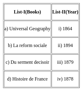
Match List-I with List-II and select the correct answer from the codes given below :

Choose the correct options from the following:

Detailed Solution for Kerala SET Paper 2 Mock Test - 4 (Geography) - Question 10

Universal Geography is the work of Elisee Recule published in the year 1894

La reform Sociale is the work by Le play published in the year 1864

Du serment decisoir is the work by Paul de Rousiers published in the year 1878

Histoire de France is the work of Edmond demolins published in the year 1879

Kerala SET Paper 2 Mock Test - 4 (Geography) - Question 11
Pairs of world species and their habitats are presented. Tell the wrong pair
Detailed Solution for Kerala SET Paper 2 Mock Test - 4 (Geography) - Question 11

The Correct Answer is Sakai - Siberia

Key Points

  • Pygmy - Congo Basin
    • The African Pygmies (or Congo Pygmies, variously also Central African foragers, "African rainforest hunter-gatherers" (RHG) or "Forest People of Central Africa") are a group of ethnicities native to Central Africa, mostly the Congo Basin style traditionally subsisting on a forager and hunter-gatherer lifestyle.
  • Badu-Saudi Arab.
    • With General, the Bedouin were no longer seen as an archaic race towering over a linear hierarchy of Arab races, but as stylea foreign race style whose presence in Palestine represented a sad chapter of racial assimilation in the unfolding history of conquests.
  • Eskimo
    • Eskimo is an exonym used to refer to two closely related Indigenous peoples: the Inuit and the Yupik of eastern Siberia and Alaska.
    • A related third group, the Aleut, which inhabit the Aleutian Islands, are generally excluded from the definition of Eskimo.

Additional Information

The Major Divisions of the Human Race

  • Most anthropologists recognize 3 or 4 basic races of man in existence today
    • The ethnographic division into races from Meyers Konversationslexikon of 1885-90 is listed: Caucasian races (Aryans, Hamites, Semites) Mongolian races (northern Mongolian, Chinese and Indo-Chinese, Japanese and Korean, Tibetan, Malayan, Polynesian, Maori, Micronesian, Eskimo, American Indian),
    • Negroid races (African, Hottentots, Melanesians/Papua,
    • “Negrito”, Australian Aborigine, Dravidians, Sinhalese).
Kerala SET Paper 2 Mock Test - 4 (Geography) - Question 12

When does most of the rainfall occur over a large part of the Indian region? 

Detailed Solution for Kerala SET Paper 2 Mock Test - 4 (Geography) - Question 12

Answer: Option 3) June-September

Key Points

INDIAN MONSOON:

The Indian region experiences a wide range of climatic conditions, including tropical, subtropical, and temperate climates. The monsoonal climate is one of the most significant features of India's climate, and it is characterized by distinct wet and dry seasons.

  • Option 1: October–November

This option is incorrect. While some parts of India do receive rainfall during October and November, most of the rainfall over a large part of the Indian region occurs during the summer monsoon season.

  • Option 2: December–February

This option is incorrect. The winter months (December-February) are generally dry in most parts of India.

  • Option 3: June–September

This option is correct. Most of the rainfall over a large part of the Indian region occurs during the summer monsoon season, which typically lasts from June to September. Monsoon or rainy season, lasting from June to September. The season is dominated by the humid southwest summer monsoon, which slowly sweeps across the country beginning in late May or early June. Monsoon rains begin to recede from North India at the beginning of October. South India typically receives more rainfall.

  • Option 4: March–May

This option is incorrect. The pre-monsoon season (March-May) is generally characterized by dry and hot weather in most parts of India.

Hence,

The correct answer is Option 3: June–September.

Kerala SET Paper 2 Mock Test - 4 (Geography) - Question 13
Which one of the following instrument is used for determination of degree of stability or instability of an air parcel?
Detailed Solution for Kerala SET Paper 2 Mock Test - 4 (Geography) - Question 13

 Radiosondes are balloons which fly at different levels to sense different weather phenomena, like stability and unstability of weather. Thus, radiosondes with help of radio waves measure the various weather formations.

Thus, the Correct answer is B.

Kerala SET Paper 2 Mock Test - 4 (Geography) - Question 14

Which of the following states is sole producer of agate, chalk, and perlite in India?

Detailed Solution for Kerala SET Paper 2 Mock Test - 4 (Geography) - Question 14

Gujarat is the sole producer of agate, chalk, and perlite and is leading producer of fluorite (concentrate), fireclay, silica sand, lignite, laterite, petroleum and natural gas and bauxite in the country. State is the sole holder of country’s resources of perlite, 66% of fluorite, 28% of diatomite, 18% of bentonite and 12% of wollastonite. [Ministry of Mines]

So, the correct option is C.

Kerala SET Paper 2 Mock Test - 4 (Geography) - Question 15
Match List I with List II

Detailed Solution for Kerala SET Paper 2 Mock Test - 4 (Geography) - Question 15

Infant mortality rate refers to the death rate among infants and is calculated for connoting mortality among the children of less than one year of age. IMR is the ratio of the number of deaths among children under one year of age to the number of live births.

Life expectancy at birth is a health indicator which indicates the number of years a person, whether a male or female would live after birth. Due to improvement in the medical field, the life expectancy has increased.

Crude death rate is the simplest measure of mortality indicating the number of deaths in a particular year per 1000 of population.

Total Fertility rate is known as the number of children born to a woman during her entire reproductive age and the TFR has decreased in India from 6 to 3 in 2003.

Kerala SET Paper 2 Mock Test - 4 (Geography) - Question 16

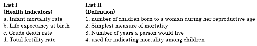
Match the list one with list two.

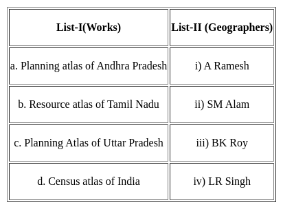
Choose the correct option from below:

Detailed Solution for Kerala SET Paper 2 Mock Test - 4 (Geography) - Question 16


There has been good progress in the field of cartography in India with Years. Biggest contributors for the same were Survey of India and NATMO.

Planning Atlas of Andhra Pradesh was the work of SM Alam.

Resource atlas of Tamil Nadu is the work of A Ramesh

Planning atlas of Uttar Pradesh is the work of LR Singh

Census atlas of India is the work of BK Roy.

Thus, the Correct answer is B.


Kerala SET Paper 2 Mock Test - 4 (Geography) - Question 17
Which of the following method is related with Human geography?
Detailed Solution for Kerala SET Paper 2 Mock Test - 4 (Geography) - Question 17

The correct answer is Both 1 and 2.

Key PointsHuman Geography

  • Human geography uses the full sweep of quantitative and qualitative methods from across the social sciences and humanities, mindful of using them to provide a thorough geographic analysis.
  • It also places emphasis on fieldwork and mapping, and has made a number of contributions to developing new methods and techniques, notably in the areas of spatial analysis, spatial statistics, and GIScience.
  • Quantitative Methods in Geography will be composed of lectures, discussions and exercises and is designed as an undergraduate level introduction to spatial analysis and the application of statistical methods in a spatial context.
  • Qualitative method is the collection of information about human behaviour and perception. It is about focusing in depth to find out why and how certain activities and events occur.
Kerala SET Paper 2 Mock Test - 4 (Geography) - Question 18

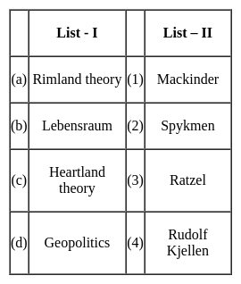
Match the concepts (List - I) with their proponents (List - II) selecting correct answer from the codes given below :

Detailed Solution for Kerala SET Paper 2 Mock Test - 4 (Geography) - Question 18

The correct answer is (a) - (2), (b) - (3), (c) - (1), (d) - (4)

Key Points

  • Heartland theory was given by British political geographer H J Mackinder in the year 1904. "The Geographical Pivot of History" is an article submitted by Halford John Mackinder in 1904 to the Royal Geographical Society that advances his heartland theory. In this article, Mackinder extended the scope of geopolitical analysis to encompass the entire globe.
  • Heartland theory believed that whoever controls the heartland( Siberia and part of central Asia) will control the world islands whereas rimland theory believed that whoever controls the rimland (Inner marginal crescent) comprised Europe, North Africa, West Asia, India, South East Asia, and part of China will control the world islands
  • Spykeman propounded the Rimland theory in opposition to the Heartland theory of Mackinder. Spykman proposed a theory that countered Mackinder's Heartland Theory. According to his rimland theory, the coastal areas or littorals of Eurasia are key to controlling the World Island, not the Heartland. As per Spykman, landlocked states usually faced security challenges from their immediate neighbors.
  • The ideology of Nazism Party workers and also Adolf Hitler was Lebensraum which meant that the living space or territory area extended to enable the material resources and the power of the German Nation and also established the new territory for their people settlement.
  • The term Lebensraum was coined by the German geographer, Friedrich Ratzel (1844-1904). During the last two decades of the 19th century, Ratzel developed a theory according to which the development of all species, including humans, is primarily determined by their adaptation to geographic circumstances.
  • Geopolitics, analysis of the geographic influences on power relationships in international relations.
  • The word geopolitics was originally coined by the Swedish political scientist Rudolf Kjellén about the turn of the 20th century, and its use spread throughout Europe in the period between World Wars I and II (1918–39) and came into worldwide use during the latter.
Kerala SET Paper 2 Mock Test - 4 (Geography) - Question 19
Read the following statements and select the correct answer from the code given below.

(a) Ratzel applied organic theory to biogeography.

(b) Humboldt was of the opinion that life of people living in islands, plains and mountains was similar.

(c) Kant described the impact of environment in late 18th century.

(d) Darwin’s theory of origin of species is dependent on the idea that the nature changes with time.

Code:

Detailed Solution for Kerala SET Paper 2 Mock Test - 4 (Geography) - Question 19

Ratzel developed the concept of Lebensraum (living space). In that he applied the concepts of organic theory to Political Geography. Humboldt travelled extensively through the world and noted that the mode of life was different in different places, such as coastal plains differed from islands, river basins or mountainous regions. Immanuel Kant, in 18th century concluded from his research that environment had a huge impact on human lifestyle. Charles Darwin, in his book Origin of species claimed that things in nature change with time.

Thus, the correct answer is D.

Kerala SET Paper 2 Mock Test - 4 (Geography) - Question 20
The mean of five numbers is 18. If one number is removed the mean is 16. The number removed is
Detailed Solution for Kerala SET Paper 2 Mock Test - 4 (Geography) - Question 20

Concept use:

Mean = Sum of Observation/Total Number of Observation

Calculations:

The mean of five numbers is 18

∴ Sum of Observation = 5 × 18 = 90

If one number is removed the mean is 16.

∴ Total number of Observation = 4

∴ Sum of new Observation = 4 × 16 = 64

Sum of new Observation - Sum of Observation = 90 - 64 = 26 (The Number removed from the data)

Hence, The Correct Answer is 26.

Kerala SET Paper 2 Mock Test - 4 (Geography) - Question 21
Given below are two statements, one labelled as assertion(A) and other labelled as reason(R).

Assertion(A)- Principal component analysis identifies duplicate data over several datasets.

Reasoning(R)-It aggregates only essential information .

Detailed Solution for Kerala SET Paper 2 Mock Test - 4 (Geography) - Question 21

Sometimes, variables are highly correlated in such a way that it would be duplicate information found in another variable. Principal component analysis identifies duplicate data over several datasets. It creates a new dataset with only the essential information.

Thus, the correct answer is A.

Kerala SET Paper 2 Mock Test - 4 (Geography) - Question 22
Who propounded the concept of paradigm?
Detailed Solution for Kerala SET Paper 2 Mock Test - 4 (Geography) - Question 22

There have been various evolutionary phases in geography. It passed from descriptive and teleological phase to the quantitative radical and dialectical materialism stage. There was a shift of approaches that were conventionally used to a set of new ways of approaches. This was called paradigm which was for the first time propounded by Thomas Kuhn in 1962.

Kerala SET Paper 2 Mock Test - 4 (Geography) - Question 23
Read the following statements and choose the correct answer from the code given below:

(a) Altimetric frequency histograms and curves are two basic techniques to study high lands of geomorphological significance.

(b) Baulig suggested use of grid method to remove deficiencies in altimetric analysis.

(c) The accuracy of altimetric analysis depends upon the benchmarks.

(d) The grid method is used in altimetric analysis when there is deficiency in density of spot heights.

Code:

Detailed Solution for Kerala SET Paper 2 Mock Test - 4 (Geography) - Question 23

Altimetric analysis is the use of altimetric frequency histograms and curves for study of geomorphological significance. The accuracy of altimetric analysis depends on the density of spot-heights in an area. The grid method was suggested by Baulig to remove the deficiencies in density of spot-height. It is common to use grid method when there is deficiency in density of spot-heights.

Kerala SET Paper 2 Mock Test - 4 (Geography) - Question 24
Which of the following is not a component of human-made environment?
Detailed Solution for Kerala SET Paper 2 Mock Test - 4 (Geography) - Question 24

The environment is the air, water, and land in or on which people, animals, and plants live. Environment is our basic life support system. It provides the air we breathe, the water we drink, the food we eat and the land where we live. 

  • It is a combination of natural and human-made phenomena. While the natural environment refers to both biotic and abiotic conditions existing on the earth.
  • Land, water, air, plants and animals comprise the natural environment.
  • The term built environment, or built world, refers to the human-made surroundings that provide the setting for human activity, ranging in scale from buildings to parks.
  • It has been defined as "the human-made space in which people live, work, and recreate on a day-to-day basis." Settlement, agriculture, and transport are human-made environments but the land is not.

Hence, it is clear that land is not a component of a human-made environment.

Kerala SET Paper 2 Mock Test - 4 (Geography) - Question 25

Read the following statements and state which of them are true?

Spykman's Rimland Theory was a variant of Mackinder's Heartland Model. Both the models emphasised on

Detailed Solution for Kerala SET Paper 2 Mock Test - 4 (Geography) - Question 25

The correct answer is the Role of the value of location in determining the political destiny of the world.

Key Points

  • Mackinder’s theory is a spatial analysis of the geopolitics in terms of its location, accessibility, and natural resource base. His theory has laid down the principle of geographical causation of history which means that the pulsations in human history have been caused by geographical conditions.
  • Mackinder interpreted history as essentially a struggle between Land & Sea Power and presented his paper “The Geographical Pivot of History” to elucidate his formula of Geographical Causation in World History.
  • For him, whoever could gain control of ‘World Island’ would be in an almost unstoppable position to dominate the entire globe. In his opinion, the heartland having Agricultural resources could conquer Europe, the Middle East & Far East.
  • The world power seemed to be centralized around the Heartland which he said had all the resources and natural defense by the physiographic factors. It is invincible and represents the supremacy of Land Power which political destiny of the world.
  • According to Mackinder -“Who rules East Europe commands the Heartland?” “Who rules Heartland commands the World-Island?” “Who rules the World-Island commands the World?”.
  • In 1944, Spykman as the point of critic or antithetic to the Heartland Theory presented his work titled “The Rimland Theory” in his book – “The Geography of Peace”. He gave a different interpretation of the relative importance of Heartland (Land Power) vis-a-vis the surrounding Inner and Outer Crescent
  • According to Spykman Sea Power has faster movement, and greater accessibility while Land can be inaccessible due to hills, rivers, deserts, etc. Sea Powers has more than 2/3rd the population of the world and is thus full of human & technological resources. Most of the population is located in Coastal areas.
  • Spykman considered geographical features as important determinants in foreign policy because of their emphasis on spatial variations.
  • In medieval human history and the pre-modern era, Naval Power had supremacy over Land power as they had Navigation Technology, Ships, etc. e.g. British, French, Germany, Portuguese, Spanish, and Italy were all sea powers and the whole world became a colonial house of these countries.
Kerala SET Paper 2 Mock Test - 4 (Geography) - Question 26
Rain shadow effect is associated with
Detailed Solution for Kerala SET Paper 2 Mock Test - 4 (Geography) - Question 26

The correct option is 2 i.e. Orographic rainfall.

  • Rainshadow effect is associated with mountains and this kind of rainfall involving geological structures are known as Orographic rainfalls.
  • Orographic rain is formed wherever moist air is forced to ascend a mountain barriers it is best developed on the windward slope.
  • It is also known as relief rain.
  • The leeward side gets less precipitation and hence remain dry. Ex- Vidarbha region of Maharashtra which is on the leeward side of Western Ghats.
  • Cyclonic rainfall is associated with cyclonic activity in temperate regions or in tropical regions. It is caused due to the convergence of two different air masses with different temperatures.
  • It is also known as frontal rain.
  • Conventional rain is caused by convection currents.
  • When the earth's surface is heated by conduction moisture-laden vapours rises because of heated air expands and becomes lighter this vapour condenses into cumulonimbus clouds. It is mostly associated with cumulonimbus clouds and thunderstorms.
Kerala SET Paper 2 Mock Test - 4 (Geography) - Question 27

Which of the following is not correctly matched:

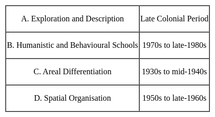
Approaches - Periods

Detailed Solution for Kerala SET Paper 2 Mock Test - 4 (Geography) - Question 27

With this, new approaches can cross like welfare or humanistic school of thought, radical school of thought and behavioural school of thought.

Kerala SET Paper 2 Mock Test - 4 (Geography) - Question 28

Process of chemical weathering is represented by-

Detailed Solution for Kerala SET Paper 2 Mock Test - 4 (Geography) - Question 28

Chemical weathering is the weakening and subsequent disintegration of rock by chemical reactions. These reactions include oxidation, hydrolysis, and carbonation. These processes either form or destroy minerals, thus altering the nature of the rock's mineral composition

Kerala SET Paper 2 Mock Test - 4 (Geography) - Question 29

The Indian state with lowest sex ratio is

Detailed Solution for Kerala SET Paper 2 Mock Test - 4 (Geography) - Question 29

According to census 2011 the sex ratio in Haryana is 879. Although government has claimed touch 950 mark.

Kerala SET Paper 2 Mock Test - 4 (Geography) - Question 30

The largest number of Tiger Reserves are located in

Detailed Solution for Kerala SET Paper 2 Mock Test - 4 (Geography) - Question 30

Pench Tiger Reserve in Maharastra is minimum in area. As per website of NTCA, Sunderbans in West Bengal has the largest number of Tigers. In 2002-03, Madhya Pradesh was home to maximum number of Tigers.

View more questions
30 tests
Information about Kerala SET Paper 2 Mock Test - 4 (Geography) Page
In this test you can find the Exam questions for Kerala SET Paper 2 Mock Test - 4 (Geography) solved & explained in the simplest way possible. Besides giving Questions and answers for Kerala SET Paper 2 Mock Test - 4 (Geography), EduRev gives you an ample number of Online tests for practice
Download as PDF