KTET Exam  >  KTET Tests  >  Kerala SET Mock Test Series 2025  >  Kerala SET Paper 2 Mock Test - 3 (Geography) - KTET MCQ

Kerala SET Paper 2 Mock Test - 3 (Geography) - KTET MCQ


Test Description

30 Questions MCQ Test Kerala SET Mock Test Series 2025 - Kerala SET Paper 2 Mock Test - 3 (Geography)

Kerala SET Paper 2 Mock Test - 3 (Geography) for KTET 2025 is part of Kerala SET Mock Test Series 2025 preparation. The Kerala SET Paper 2 Mock Test - 3 (Geography) questions and answers have been prepared according to the KTET exam syllabus.The Kerala SET Paper 2 Mock Test - 3 (Geography) MCQs are made for KTET 2025 Exam. Find important definitions, questions, notes, meanings, examples, exercises, MCQs and online tests for Kerala SET Paper 2 Mock Test - 3 (Geography) below.
Solutions of Kerala SET Paper 2 Mock Test - 3 (Geography) questions in English are available as part of our Kerala SET Mock Test Series 2025 for KTET & Kerala SET Paper 2 Mock Test - 3 (Geography) solutions in Hindi for Kerala SET Mock Test Series 2025 course. Download more important topics, notes, lectures and mock test series for KTET Exam by signing up for free. Attempt Kerala SET Paper 2 Mock Test - 3 (Geography) | 120 questions in 120 minutes | Mock test for KTET preparation | Free important questions MCQ to study Kerala SET Mock Test Series 2025 for KTET Exam | Download free PDF with solutions
Kerala SET Paper 2 Mock Test - 3 (Geography) - Question 1

Given below are two statements. One is labelled as Assertion (A) and the other is labelled as Reason (R).

Assertion (A): The hilly topography of Jammu and Kashmir is most favorable for development of ground water resources.

Reason (R) : Groundwater level is falling rapidly all over the country.

Select the correct answer from options given below:

Detailed Solution for Kerala SET Paper 2 Mock Test - 3 (Geography) - Question 1

 The groundwater level in the country is falling at an alarming rate in country due to over exploitation of the same. In some districts of Haryana and Punjab, the level is decreasing at over 1 meter per year. The Hilly terrains of Jammu and Kashmir make it very hard to develop the groundwater resources in the area. Thus, (R) is true and (A) is false.

Thus, the correct answer is D.

Kerala SET Paper 2 Mock Test - 3 (Geography) - Question 2

Which of the following statements about inversion of temperature is/are correct?

1. Temperature increases with increasing altitude.

2. A long winter night with clear skies is an ideal situation.

3. It is a short term phenomenon and is common all over the globe except at the poles.

Select the correct answer using the code given below :

Detailed Solution for Kerala SET Paper 2 Mock Test - 3 (Geography) - Question 2

The correct answer is 1 and 2 only.

Key Points

Inversion of temperature:

  • Under normal conditions, temperature usually decreases with increase in altitude in the troposphere at a rate of 1 degree for every 165 metres. This is called normal lapse rate.
  • But on some occasions, the situations get reversed and the temperature starts increasing with height rather than decreasing. This is called temperature inversion. Hence, statement 1 is correct.
  • It is a reversal of the normal behavior of temperature in the troposphere. Under this meteorological phenomenon a layer of warm air lies over the cold air layer.
  • It is caused in stac atmospheric conditions while some times, it occurs due to horizontal or vertical movement of air.
  • Temperature inversion is usually of short duration but quite common nonetheless.

​​​Favourable Conditions for Temperature Inversion:

  • Long winter nights
    • Loss of heat by terrestrial radiation from the ground surface during night may exceed the amount of incoming solar radiation.
  • Cloudless and clear sky.
    • Loss of heat through terrestrial radiation proceeds more rapidly without any obstruction. Hence, statement 2 is correct.
  • Dry air near the ground surface
  • Slow movement of air
  • Snow covered ground surface
    • It results in maximum loss of heat through reflection of incoming solar radiation.
    • This regular temperature inversion in the high Arctic is caused by the lack of surface heating by the Sun, which stays below the horizon during the winter (the Polar Night), and the continuous loss of heat from the surface (through emission of infrared radiation). 
    • Hence, temperature inversion is common phenomenon at the poles. Hence, statement 3 is not correct.
Kerala SET Paper 2 Mock Test - 3 (Geography) - Question 3

Conglomerate is an example of:

Detailed Solution for Kerala SET Paper 2 Mock Test - 3 (Geography) - Question 3

Important Points

  • The conglomerate and Breccia both are two sedimentary structures.
  • They commonly form as rock-fall and debris flow deposits along cliffs, and underground along faults or where caves collapse.
  • They are both clastic sedimentary rocks composed of particles larger than two millimeters in diameter.
  • The main difference between them are as follows,

Key Points

Conglomerate:

  • A conglomerate has rounded clasts
  • The water transport rapidly rounds large clasts
  • The particle shape reveals a difference in how far the particles were transported.
  • Near the outcrop where the fragments were produced by mechanical weathering, the shape is angular.

Thus, Conglomerate is an example of a Mechanically formed sedimentary rock.

Kerala SET Paper 2 Mock Test - 3 (Geography) - Question 4
Eskimos" are associated with which geographical region?
Detailed Solution for Kerala SET Paper 2 Mock Test - 3 (Geography) - Question 4

The correct answer is Polar Region.

Key Points

  • Eskimos are the indigenous circumpolar people who have traditionally inhabited the northern circumpolar region from eastern Siberia (Russia) to Alaska (United States), Canada, and Greenland (Denmark).
  • Polar Region
    • The part of the Earth's surface forms a cap over a pole; characterized by a frigid climate.
    • There are two main polar regions in the world, which are the Arctic and the Antarctic.
    • The Arctic Circle and Arctic Tundra are found at the North Pole, and it covers nearly 5 million square miles of the
    • top of the Northern Hemisphere.

Additional Information

  • Arid Region
    • An arid region, also known as a desert, is defined by a severe lack of available water, to the extent of hindering or preventing the growth and development of plant and animal life.
    • This harsh environment is typically characterized by extremely low rainfall, high temperatures, and high evaporation rates.
    • Due to the scarcity of water, the biodiversity in arid regions is lower compared to other ecosystems.
  • Savanna Grassland
    • Savanna grasslands in Brazil are called Campos.
    • These grasslands lie between 24°S and 35°S, which includes Uruguay and parts of Paraguay, Brazil, and Argentina.
    • These are rich in plant species and are more diverse than forest ecosystems.
    • The climate here is subtropical humid and the rainfall is distributed regularly all over the year.
    • A grassland is an area that mostly comprises grasses.
  • Tropical Rainforest Region
    • The tropical rainforest is a forest with tall trees in a region of year-round high temperatures where an average of 50 to 260 inches of rain falls yearly.
    • The tropical rainforests are confined to areas of heavy rainfall.
    • Such areas are in the Western Ghats, upper parts of Assam, Tamil Nadu coast, and the island groups of Lakshadweep and Andaman & Nicobar.
    • Areas that receive more than 200 cm of rainfall and have a short dry season are the best area for the tropical rainforest.
Kerala SET Paper 2 Mock Test - 3 (Geography) - Question 5

Deutsche mark is the currency of

Detailed Solution for Kerala SET Paper 2 Mock Test - 3 (Geography) - Question 5

D-Mark (Deutsche Mark) was the official currency of the Federal Republic of Germany until 2002. First issued in 1948, it was the official currency of West Germany, and later, the unified German state until the final adoption of the euro (EUR) in 2002. The official currency code is DEM.

Kerala SET Paper 2 Mock Test - 3 (Geography) - Question 6
The spreading and merging of places from different cultures including food, clothing, and even languages that people love and enjoy every day is known as -
Detailed Solution for Kerala SET Paper 2 Mock Test - 3 (Geography) - Question 6

Correct Answer: Cultural diffusion.

Key Points 

Cultural diffusion:

  • Cultural diffusion is the spreading out and merging of pieces from different cultures.
  • These different cultures all have many diverse types of food, clothing, and even languages that people love and enjoy every day. 
  • The definition of cultural diffusion is the spread of the beliefs and social activities of one culture to different ethnicities, religions, nationalities, etc.
  • An example of cultural diffusion is the tradition of the German Christmas pickle becoming popular in the United States.

Additional Information 

Convergence culture:

  • Convergence culture is a theory that recognizes changing relationships and experiences with new media. Henry Jenkins is accepted by media academics to be the father of the term with his book Convergence Culture: Where Old and new media collide.

Cultural ecology:

  • Cultural ecology is the study of the adaptation of a culture to a specific environment and how changes in that environment lead to changes in that specific culture.
  • Cultural ecology is the study of human adaptations to social and physical environments.
  • Human adaptation refers to both biological and cultural processes that enable a population to survive and reproduce within a given or changing environment.
  • This may be carried out diachronically, or synchronically.​​

Culture Hearths:

  • Culture Hearths are the centers of origin of ancient civilizations which continue to inspire and influence modern societies of the world today. ​
Kerala SET Paper 2 Mock Test - 3 (Geography) - Question 7
In July, Inter Tropical Convergence Zone (ITCZ) is located around
Detailed Solution for Kerala SET Paper 2 Mock Test - 3 (Geography) - Question 7

The correct answer is 20° N to 25° N latitudes.

Key Points

  • The Inter-Tropical Convergence Zone, or ITCZ, is the region that orbits Earth, near the equator, where the northern and southern hemisphere trade winds converge.
  • In January the ITCZ ​​is located at approximately 15°S.
  • In July it is situated at 20°N to 25°N.

Important Points

  • The Intertropical Convergence Zone (ITCZ) is a low-pressure area located on the equator.
  • Trade winds are found in this region.
  • So the air starts rising in this area.
  • I.T.C.Z in the month of July. 20° to 25°N.
  • It is situated in the Gangetic plain around the latitudes.
  • Sometimes called a monsoon trough, this monsoon trough encourages the development of thermal low air pressure over north and north-west India.
  • Due to the northward movement of ITCZ, the trade winds of the southern hemisphere cross the equator between 40° and 60° East longitude.
  • Under the influence of the Coriolis force, the direction of these trade winds crossing the equator becomes from southwest to northeast.
Kerala SET Paper 2 Mock Test - 3 (Geography) - Question 8
Area-Cost Curve Theory for industrial location was given by
Detailed Solution for Kerala SET Paper 2 Mock Test - 3 (Geography) - Question 8

D. M. Smith gave theory of industrial location which was a combination of Weber’s and Losch’s Model. This theory is called as Area-Cost Curve theory. The theory has simplified world conditions. It states that the despite of lower revenue, entrepreneur is likely to choose a location which cost less.

Kerala SET Paper 2 Mock Test - 3 (Geography) - Question 9
In which layer of the atmosphere is Ozone gas concentrated?
Detailed Solution for Kerala SET Paper 2 Mock Test - 3 (Geography) - Question 9

The correct answer is Stratosphere.

Key Points

  • The atmosphere has 5 layers.
  • These are:
    • Troposphere
    • Stratosphere
    • Mesosphere
    • Thermosphere 
    • Exosphere
  • The troposphere is the lowest layer of Earth's atmosphere 
  • Its average height is 13 km.
  • The stratosphere lies above the Troposphere and extends up to a height of 50 km.
  • The stratosphere contains a layer of ozone gas.
  • The mesosphere lies above the Stratosphere and extends up to 80 km.
  • The ionosphere is a part of the Thermosphere.
  • It helps in radio transmission.
  • The exosphere is the upper layer of the atmosphere and has very thin air.

 Thus, we can say that Stratosphere is Ozone gas concentrated.

Kerala SET Paper 2 Mock Test - 3 (Geography) - Question 10

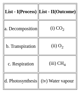
Match the List - I with List - II and select the correct answer from the code given below:

Detailed Solution for Kerala SET Paper 2 Mock Test - 3 (Geography) - Question 10

iii. Decomposition releases CH4 or methane.
iv. Transpiration releases Water vapour.
i. Respiration releases CO2 or carbon dioxide
ii. Photosynthesis releases O2 or oxygen.

Thus, the Correct answer is C.

Kerala SET Paper 2 Mock Test - 3 (Geography) - Question 11
Given below are two statements- one is labelled as Assertion (A) and the other is labelled as Reason (R):

Assertion(A)- Exogenous processes are responsible for gradation.

Reason(R)- Weathering and erosion is often described as the essential phase in the denudation process of landscapes.

Choose the correct option:

Detailed Solution for Kerala SET Paper 2 Mock Test - 3 (Geography) - Question 11

Gradation is nothing but the erosion of a rugged landscape into a level land. The gradation is achieved because of Degradation and Aggradation. Weathering and erosion have the capability to convert hard massive rocks into finer material. Hence for this, Weathering is often known as the first essential phase in the denudation or gradation of landscapes as it prepares the rock materials for transportation, depositional processes as well as provides for the degradation of landscapes.

Kerala SET Paper 2 Mock Test - 3 (Geography) - Question 12

After which period the political geography came into limelight?

Detailed Solution for Kerala SET Paper 2 Mock Test - 3 (Geography) - Question 12

Political Geography started to prosper during the 1980s. Two research areas dominated this field. Firstly, the urban conflicts and the location of 'goods' and 'bads'; secondly, the application of the concepts of electoral geography. These were identified during the 1970s and slowly this sub discipline grew because of its remarkable resurgence.

Kerala SET Paper 2 Mock Test - 3 (Geography) - Question 13
The spread of cultural traits from one region to other is called:
Detailed Solution for Kerala SET Paper 2 Mock Test - 3 (Geography) - Question 13

The correct answer is Diffusion.

Key Points

  • The spread of cultural traits from one region to another is called cultural diffusion.
  • Cultural diffusion often occurs when people move from one place to another.
  • It is the geographical and social spread of the different aspects of one more culture to different ethnicities, religions, nationalities, regions, etc.

Additional Information

Kerala SET Paper 2 Mock Test - 3 (Geography) - Question 14
If the median of 1, 2, x, 4, 5 is 3 then its mean is
Detailed Solution for Kerala SET Paper 2 Mock Test - 3 (Geography) - Question 14

Concept use:

Median of odd number of terms is middle terms

Mean = Sum of Observation/Total Number of Observation

Explanation:

If the median of 1, 2, x, 4, 5 is 3

⇒ x = 3

Mean = 1 + 2 + 3 + 4 + 5/ 5 = 15/5 = 3

Hence, The Correct Answer is 3.

Kerala SET Paper 2 Mock Test - 3 (Geography) - Question 15
Which of the following option is correct in the case of fronts and frontogenesis?
Detailed Solution for Kerala SET Paper 2 Mock Test - 3 (Geography) - Question 15

The term Frontogenesis was first used by Tor Bergeron for the creation of new fronts. Later, it was extended to include the process of regeneration of old and decaying fronts. The term is a Latin derived term. Frontogenesis occurs when the wind blows in such a way that the isotherms become packed along the leading edge of the intruding air mass.

Generally, the isobars in an air mass are smooth curves and there are no sharp bends in them. And frontal activity is always associated with cloudiness and precipitation. Since warm air moves up along the frontal surface, it cools adiabatically and thus results in cloudy condensation and precipitation.

The appearance of warm front is mostly observed by the presence of cirrus clouds.

Kerala SET Paper 2 Mock Test - 3 (Geography) - Question 16
Rainwater Harvesting is an effective technique to-
Detailed Solution for Kerala SET Paper 2 Mock Test - 3 (Geography) - Question 16

The Rainwater Harvesting involves the collection and storage of rainwater at surface or sub-surface aquifers and is a very useful method, particularly for developing countries like India. The above sentences are some of the needs and advantages of rainwater Harvesting and is necessary in areas where ground water levels are declining on regular basis and inadequate.

Kerala SET Paper 2 Mock Test - 3 (Geography) - Question 17

Consider the following statements

  1. Active remote sensing uses the sun as a source of electromagnetic energy.
  2. Passive remote sensing is significantly affected by adverse weather conditions.
  3. Active remote sensing can collect data at day and night hence having more working timeframe.
  4. Active remote sensing requires less amount of energy to generate adequate electromagnetic radiation for illumination.

Choose the incorrect statements.

Detailed Solution for Kerala SET Paper 2 Mock Test - 3 (Geography) - Question 17

Concept:

Remote sensing refers to the act of recording information about the earth’s surface by the use of sensors attached to satellites. Remote sensing plays a vital role in collecting information over large surface areas, characterizing natural features on the earth, observing and monitoring the earth and objects’ changes over time, and availing this information for processing and analysis. In remote sensing, The sun is the ultimate source of energy and is very useful for illumination. Satellites have imaging sensors used to monitor the earth through imagery collection.

Active and passive remote sensing

1. Source of Energy

Active remote sensing uses its energy source to illuminate electromagnetic radiation to the target and record the reflected radiation measurement. In contrast, passive remote sensing has to use naturally occurring energy that illuminates the target and reflects the electromagnetic radiation to the remote senor to record the electromagnetic radiation. The primary source of energy in passive remote sensing is sunlight.

2. Time of Recording

Passive remote sensing can only function when the natural energy source is available, i.e., in most cases, the sun is only present during the daytime, limiting the working timeframe. However, active remote sensing can measure radiation anytime despite what time of day, night, or season since they have their energy source, which emits their electromagnetic radiation to obtain a measurement, hence strong capabilities of collecting imagery day and night.

3. Weather Conditions

Active remote sensing is not affected by poor weather conditions since it emits its energy directly to the target with no interference by adverse weather. However, Passive remote sensing is significantly affected by adverse weather conditions like heavy clouds, which may block enough sunlight illuminating the target; hence, remote sensors cannot capture the correct reading of the electromagnetic radiation reflected.

4. Amount of Energy
Active remote sensing requires a large amount of energy to generate adequate electromagnetic radiation for illumination. However, passive remote sensing only requires sunlight to obtain reflection of electromagnetic radiation, to record measurements from the illuminated object.

5. Areas of Survey
Passive remote sensing focuses on land use, land cover analysis, and small-scale mapping requirements. On the other hand, active remote sensing targets areas like flooding, geological data, volcanic eruptions, earthquake disaster management, soil study, and mapping of mineral zones.

Kerala SET Paper 2 Mock Test - 3 (Geography) - Question 18
Who tried to combine the three branches of geography general, mathematical and physical, and, chorology in his book ‘Geographia Generalis’?
Detailed Solution for Kerala SET Paper 2 Mock Test - 3 (Geography) - Question 18

Correct Answer: Varenius.

Key Points

  • This was followed by another exclusive volume on the religions of Japan.
  • However, Varenius’ most significant contribution was his book, ‘Geographia Generalis’ (1650) which was one of the first attempts to combine three branches of geography—general (systematic), mathematical and physical—and, chorology (the science of space).
  • This book consisted of three parts:
    • The absolute or terrestrial part deals with the shape and size of the earth as well as the physical geography of continents, seas, and the atmosphere. 
    • The relative or the cosmic part describes the relation between the earth and other celestial bodies especially the sun and its effects on global climate. 
    • The comparative part focuses on the principles of navigation and the location of different places in relation to each other. 
  • In the preface of Geographia Generalis, Varenius advocated that the description of particular places should take into consideration the:
    • Celestial conditions—climate,
    • Terrestrial conditions—relief, soil, vegetation, and biotic life,
    • Human conditions—population, settlement, trade, forms of government. 

Important Points 

  • Geographia generalis (1650), Varenius’s best-known work, sought to lay down the general principles of geography on a wide scientific basis according to the knowledge of the day.
  • It not only was systematic geography on a scale not previously attempted but also contained a scheme for special, now known as regional, geography.
  • That major work was frequently revised, and the edition of 1672 had improvements by Sir Isaac Newton.
  • Varenius’ Geographia Generalis could have had a second volume but it could not be completed owing to his untimely and premature death in 1650. This book was translated into several editions in Latin.
Kerala SET Paper 2 Mock Test - 3 (Geography) - Question 19
Which factor is NOT a parameter for declaring an area as an urban area?
Detailed Solution for Kerala SET Paper 2 Mock Test - 3 (Geography) - Question 19

The correct answer is At least 60% of the population lie above poverty line.

Key Points

  • Urban areas:
    • These areas are defined as places that are extremely developed, have lots of options for employment and education, and have excellent infrastructure.
    • These areas have improved railroads, homes, businesses, bridges, and roadways.
    • There is typically a high population density in urban areas, such as cities and towns.
  • A person is said to be living in poverty if they fall below a certain level, known as the poverty line. Typically, the cost of essential necessities like food, housing, and clothing is used to determine the poverty line.
  • "At least 60% of the population lie above poverty line" is not a parameter for declaring an area as an urban area.

Additional Information

  • Since the state government does not have any objective standards for defining what constitutes a "urban settlement," the national government, acting through the Office of Registrar General and Census Commissioner of India, defines a "urban settlement" according to the following standards:
    • (a) if it has an urban local government (i.e., statutory towns notified by the state government)
    • (b) any place that satisfies the following three criteria:
      • (i) minimum population of 5,000
      • (ii) at least 75 percent of male working population engaged in non-agricultural activities
      • (iii) population density of at least 400 persons per sq. km (1,000 persons per sq. mile).
  • The term "population density" describes the amount of people residing in a specific area, typically expressed as "persons per square kilometre."
  • The process by which a community moves from rural to urban settings, or from one location to another, is known as urbanisation. High population densities, non-agricultural jobs, and advanced infrastructure and services are characteristics of urban regions.
  • The suburbs are located outside of cities and typically have a lower population. They go by the name of residential areas as well. Compared to the city, the suburbs have larger homes, more parks, and open areas. A large number of city dwellers relocate to the suburbs. We call this suburban migration.
  • The metropolitan region and the rural area are diametrically opposed. In comparison to metropolitan areas, rural areas have lower population densities and fewer options for employment and education. Agriculture is the main industry in rural areas.
Kerala SET Paper 2 Mock Test - 3 (Geography) - Question 20
National Clean Air Programme (NCAP) was launched in
Detailed Solution for Kerala SET Paper 2 Mock Test - 3 (Geography) - Question 20

 National Clean Air Programme (NCAP) was launched on 10th January 2019 by the Ministry of Environment, Forest and Climate Change. The tentative national level target of 20%–30% reduction of PM2.5 and PM10 concentration by 2024 is proposed under the NCAP taking 2017 as the base year for the comparison of concentration.

Kerala SET Paper 2 Mock Test - 3 (Geography) - Question 21

The use of microorganism metabolism to remove pollutants such as oil spills in the water bodies is known as :

Detailed Solution for Kerala SET Paper 2 Mock Test - 3 (Geography) - Question 21

Bioremediation is a process used to treat contaminated media, including water, soil and subsurface material, by altering environmental conditions to stimulate growth of microorganisms and degrade the target pollutants.

Kerala SET Paper 2 Mock Test - 3 (Geography) - Question 22
The East-West Corridor connects which of the following cities?
Detailed Solution for Kerala SET Paper 2 Mock Test - 3 (Geography) - Question 22

The East-West corridor has been built to connect the cities of Silcher in Assam and Porbandar in Gujrat. The length of roads in the corridor is 3300 km. The corridor is a part of North-South-East-West Corridor, the largest ongoing highway project in the country.

Thus, the correct answer is D.

Kerala SET Paper 2 Mock Test - 3 (Geography) - Question 23
Which famous philosopher is known for his theory of mind-body dualism?
Detailed Solution for Kerala SET Paper 2 Mock Test - 3 (Geography) - Question 23

The correct answer is René Descartes
Important Points

René Descartes, a French philosopher from the 17th century, is known for his theory of mind-body dualism, also known as Cartesian Dualism. According to his theory, the mind and the body are two fundamentally different natures.

  • The mind (or soul) is a non-physical and conscious subject of thought and value, while the body is the physical object located in space and time.
  • Despite their distinct natures, Descartes believed the two interact in the brain's pineal gland. This perspective has significantly influenced western philosophical thought on the mind-body problem.
  • Descartes proposed the theory of mind-body dualism in his Meditations on First Philosophy, which asserts that the mind and the body are two fundamentally different things.
  1. Mind: Descartes stated that the mind, also referred to as the 'thinking substance' or 'res cogitans', does not exist in space and is not subject to the laws of physics. It is self-aware and conscious, capable of feelings, thoughts, and other conscious experiences.

  2. Body: The body, or 'extended substance' ('res extensa'), is a physical entity. It exists in space, and it can move and be moved. It's subject to mechanical and physical laws and can be observed objectively.

  • This dualistic view is often termed 'interactionist dualism' as Descartes believed that the mind and body, despite their distinct natures, interact with each other in the pineal gland of the brain.

Descartes' dualism has had significant implications in philosophy and science. It has shaped discussions on the mind-body problem - the question of how the mind (mental) and body (physical) interact and influence each other. This has wide-ranging consequences in psychology, cognitive science, neurology, and artificial intelligence.

  • However, Cartesian Dualism has faced criticism and challenges. One such critique is the 'interaction problem' which questions how two completely different substances (the nonphysical mind and the physical body) could possibly interact.
  • Despite these criticisms, Cartesian Dualism continues to be a crucial philosophical concept, highlighting the perceived dichotomy between the mental and the physical - a foundational idea in Western thought.
Kerala SET Paper 2 Mock Test - 3 (Geography) - Question 24
Which curve is used to show the land elevations?
Detailed Solution for Kerala SET Paper 2 Mock Test - 3 (Geography) - Question 24

A hypsometric curve is a histogram or a cumulative distribution function of elevations in a geographic area. Differences in hypsometric curves between landscapes arise because the geomorphic process that shape the landscape may be different. Thus the differences in the shape show the differences in the elevation of the landscapes on the surface of the earth.

Thus, the correct answer is B.

Kerala SET Paper 2 Mock Test - 3 (Geography) - Question 25
Which one of the following is the cause of long-term sea-level change?
Detailed Solution for Kerala SET Paper 2 Mock Test - 3 (Geography) - Question 25

​The correct answer is the Melting of ice sheets.

Key Points

  • Sea-level change:
    • The sea level is currently rising at a rate of 0.13 inches per year.
    • It has risen 8.9 inches between 1880 and 2015, much faster than in the previous 2,700 years.
  • Factors responsible:
    • Climate change, especially global warming,
    • Thermal Expansion,
    • Melting Ice sheet and
    • Loss of Greenland and Antarctica’s ice sheets. Hence option 4 is correct.

Confusion Points

  • Melting of icebergs v/s Melting of ice sheets:
  • Icebergs:
    • ​They are ice that broke off from glaciers and are floating in open water.
    • Melting of icebergs or ablation release fresh water and reduce the salinity of the surrounding sea. This instance can lead to a sudden sea level rise but may not contribute significantly to long-term sea level change . Hence option 3 is incorrect. 
  • Ice sheets are huge and they create broad domes and spread out from their centres in all directions.
    • The melting of ice sheets is the cause of long-term sea-level change.

Additional Information

  • Atmospheric disturbances:
    • Atmospheric pressure changes can bring strong on-shore winds within a storm (hurricane/ cyclone/typhoon). But do not lead to long-term sea level changes. Hence option 1 is incorrect.
  • Change in marine water density:
    • It can happen due to Ocean warming which contributes to global mean sea level rise by reducing the density of seawater. However, it does not lead to long-term sea level changes. Hence option 2 is incorrect.
Kerala SET Paper 2 Mock Test - 3 (Geography) - Question 26

Consider the following statements-

1. These winds blow from the subtropical high-pressure belts towards the sub-polar low-pressure belts.

2. They are stronger in the southern hemisphere. 

3. These winds are best developed between 40° and 65°S latitudes.

Statements given-above are about which planetary wind?

Detailed Solution for Kerala SET Paper 2 Mock Test - 3 (Geography) - Question 26

The correct answer is Westerlies.

Key Points

  •  Westerlies:
    • The westerlies are the winds blowing from the subtropical high-pressure belts towards the subpolar low-pressure belts.
    • They blow from south­west to north-east in the northern hemisphere and north-west to south-east in the southern hemisphere.
    • The westerlies of the southern hemisphere are stronger and persistent due to the vast expanse of water, while those of the northern hemisphere are irregular because of uneven relief of vast land-masses.
    • The westerlies are best developed between 40° and 65°S latitudes.

Additional Information

  • Primary Winds or Prevailing Winds or Permanent Winds or Planetary Winds
    • These are the planetary winds which blow extensively over continents and oceans.
    • The two most well-understood and significant winds for climate and human activities are trade winds and westerly winds.
  • Trade Winds:
    • The trade winds are those blowing from the sub-tropical high-pressure areas towards the equatorial low-pressure belt
    • Therefore, these are confined to a region between 30°N and 30°S throughout the earth’s surface.
    • They flow as the north-eastern trades in the northern hemisphere and the south-eastern trades in the southern hemisphere.
    • Trade winds are descending and stable in areas of their origin (sub-tropical high-pressure belt), and as they reach the equator, they become humid and warmer after picking up moisture on their way.
    • The trade winds from two hemispheres meet at the equator, and due to convergence they rise and cause heavy rainfall.
  • Polar easterlies:
    • The Polar easterlies are dry, cold prevailing winds blowing from north-east to south-west direction in Northern Hemisphere and south-east to the north-west in Southern Hemisphere.
    • They blow from the polar high-pressure areas of the sub-polar lows
Kerala SET Paper 2 Mock Test - 3 (Geography) - Question 27
Who  emphasized the point that geography is not a dry gazetteer of names of places, rivers, mountains, and trade routes?
Detailed Solution for Kerala SET Paper 2 Mock Test - 3 (Geography) - Question 27

The correct answer is C. Ritter.
Key Points

  • German geographer Carl Ritter is commonly associated with Alexander von Humboldt as one of the founders of modern geography.
  • However, most acknowledge Ritter's contributions to the modern discipline to be somewhat less significant than those of von Humboldt, especially as Ritter's life work was based on the observations of others.
  • Ritter, in his class lectures, emphasized the point that geography is not a dry gazetteer of names of places, rivers, mountains, and trade routes.
  • It is a subject of great importance that deals with man and nature’s interrelationship. 
  • He developed the concept of “unity in diversity.” Ritter was chiefly concerned with studies of human geography.
  • He believed, as did Vidal de la Blache much later, that earth and its inhabitants stand in the closest reciprocal relations, and one cannot be truly presented in all its relationships without the other.
  • Hence history and geography must always remain inseparable.
  • Land affects the inhabitants and the inhabitants of the land. In simple words, every naturally bounded area is united in respect of climate, production, culture, population, and history.
Kerala SET Paper 2 Mock Test - 3 (Geography) - Question 28
Which of the following are cruciform settlements?
Detailed Solution for Kerala SET Paper 2 Mock Test - 3 (Geography) - Question 28

The correct answer is 1 and 2 Both options.

Key Points

Cruciform settlements

  • T-shaped and Y-shaped both are Cross-shaped or cruciform settlements.
  • T -shaped settlements develop at tri-junctions of the roads.
  • While Y-shaped settlements emerge as the places where two roads converge on the third one and houses are built along these roads.
  • Cruciform settlements develop on the cross-roads and houses extend in

​Y-shaped settlement

All the rural settlements:

Kerala SET Paper 2 Mock Test - 3 (Geography) - Question 29

Which among the following is / are common features of the drainage pattern of Ganges river system?

  1. Parallel Courses of rivers
  2. Tributaries meeting their master streams at acute angles
  3. Most rivers are of perennial nature
  4. Lower reaches of rivers with steep gradient suitable for hydropower generation

Choose the correct option from the codes given below:

Detailed Solution for Kerala SET Paper 2 Mock Test - 3 (Geography) - Question 29

The drainage of the Gangetic region is dendritic with parallel courses and acute angle functions of tributaries with their master stream s. Most of the rivers are perennial streams with well-defined courses and gentle gradient. While the upper reaches of the rivers are suitable for generating hydel power. the mainstreams in the plains provide water for canal irrigation and are also used for navigation purposes.

Kerala SET Paper 2 Mock Test - 3 (Geography) - Question 30

Geographers would most likely use the term shatter belt—an area of recurrent political division and fragmentation—to describe which of the following regions of Europe?

Detailed Solution for Kerala SET Paper 2 Mock Test - 3 (Geography) - Question 30

This question requires the examinee to demonstrate knowledge of the physical and human characteristics of different world regions.

The political and ethnic conflicts of the late twentieth century were only the last in a long series of struggles that have made the Balkan Peninsula a good example of what geographers mean when they use the term shatter belt, a region that tends toward fragmentation from the effect of powerful colliding cultural and political forces.

View more questions
30 tests
Information about Kerala SET Paper 2 Mock Test - 3 (Geography) Page
In this test you can find the Exam questions for Kerala SET Paper 2 Mock Test - 3 (Geography) solved & explained in the simplest way possible. Besides giving Questions and answers for Kerala SET Paper 2 Mock Test - 3 (Geography), EduRev gives you an ample number of Online tests for practice
Download as PDF